

This walk: 2017-7-25. Rees Jeffreys car park, Longford Leat, Grimstone & Sortridge Leat, Merrivale Quarry (=Tor Quarry), Little Staple Tor, rock pan, Middle Staple Tor, Quarrymen's Path, Great Staple Tor, Great Steeple Tor, PW boundary stone, Duke of Bedford stones and markers, Roos Tor, firing range flagpole, Great Mis Tor, Cox Tor, Cock's Tor, Fur Tor, quartz country rock, sett makers' bankers, "shaker".
Walk details below - Information about the route etc.
Previous walks in this area: 20th January 2010, 29th February 2012, 11th June 2014 and 7th August 2014
Google Satellite map + GPS track of the walk
The Rees Jeffreys car park at SX 539 750, on the north side of the B6657 road ....... this was a former "Gravel Pit" on the 1890s-1920s 25-inch OS map .....

Remember?!
A few cars turned up.
Plaque in the car park mentioning the Rees Jeffreys Road Fund - this links to their web site! See also William Rees Jeffreys, the man, who was responsible for roads being classified as "A" & "B" roads. Photograph taken from 3rd November 2010 because the plaque has been vandalised by hammering the raised lettering flat.

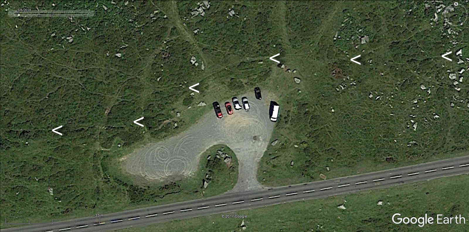
Image from Google Earth 2017, showing the dry channel of the Longford Leat passing just north of the car park, indicated by white markers. It is not very photogenic in this area. A few photographs were taken during the third reconnaissance for this walk that looked at an easterly route and can be found here:13th July 2017, but its not very photogenic there either.
A confusion of leats: A few paces above the car park runs a dry leat channel named as "Longford Leat" by Eric Hemery (1983), High Dartmoor, Robert Hale, London, pages 1011, 1015, 1041 & 1042. By the name, one would surmise that it runs to Longford; Higher Longford and Lower Longford are just west of Barn Hill, off the road to Tavistock, but this leat seems to run somewhere else (see below). Hemery (page 1011) reports that this dry channel on Barn Hill (above the running G & S Leat) once supplied Longford Mill and that the occupier of Higher Longford wrote over a hundred years ago to the Duchy Steward, complaining that miners were interfering with the water, i.e. pre-1883.
The main leat still running in this area is the Grimstone & Sortridge Leat. In describing the G & S head weir, Brown says that the higher, now dry leat channel, has its head weir some distance upstream from that of the G & S Leat. Here comes the first confusion: This higher leat was said to be cut to supply water for Wheal Fortune mine at Merrivale Bridge soon after the mine opened. This caused a lot of upset. Maristow Estate's Steward wrote an angry letter on behalf of Sir Ralph Lopes in April 1837 to his tenant at Longash. There was some stating of who owned which land, with the Duke of Bedford and the Courtenay family of Walreddon Estate both being involved. It transpired that as lord of the manor, Lopes owned the water rights, but the leat in question was not the mine leat but another lower down the slope (where ran the G & S Leat?) - this leat also caused acrimony. Source: Mike Brown (2001) Guide to Dartmoor, CD-ROM, Dartmoor Press, Grid Square 5560 7769. This separate head weir can be inferred from modern mapping by following the line of the dry leat back and then projecting its source.
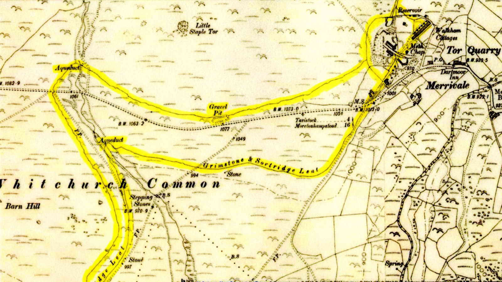
This OS 6-inch map 1888-1913 shows only one head weir, for the Grimstone & Sortidge Leat, with a possible splitting of the leat at Merrivale Quarry (the quarry opened in 1876), then two leats and two aqueducts running in parallel for some distance, one north and one south of the B3357 road. Here comes the second confusion: There then seems to be an "H" junction at Windy Post (Beckamoor Cross) where the labelled G&S leat joins with the higher contouring leat, beyond which one branch runs on to an old gravel pit and thence close to Oakley Cottage. The modern map shows this runs on and there are several bullseye stones along it that supply water to properties.. Another branch continues around Feather Tor and Heckwood Tor, past Pewtor Cottage and on to a reservoir south of Riland Plantation, just north of Grimstone:This branch also splits to a reservoir at Sortridge. these are both about a kilometre north of Horrabridge. This 1884 6-inch single sheet map also shows only one head weir, either the higher leat was overlooked or it was cut afterwards. As the main lengths of these two long leats seem to go to the same places, perhaps the original leat was re-cut for some reason?
A later explanation: Eric Hemery (1986), Walking the Dartmoor Waterways, David & Charles, Newton Abbot, pages 34-45 notes that the farms Grimstone and Sortridge have probably been receiving their water by this leat for possibly more than 500 years. Sortridge Manor was built in 1558. Grimstone received mains water in 1963 but Sortridge still receives leat water. The parallel dry channel was cut around 1876 when William Duke began to develop Tor Quarry, to avoid interference with the water. The lengthy diversion channel was opposed by the commoners and it was abandoned. However, it was used for a while because there is a link channel to the running leat, south of the main road. Also, there is a water-worn channel beyond the aqueduct that was north of the road, over Beckamoor Coombe. The channel that supplied the Wheal Fortune mine (mentioned in paragraph 1) was apparently a branch off the G & S Leat. The G & S Leat also supplied the Sortridge Consols copper mine that was west of Barn Hill, on the east side of the Horrabridge-Tavistock road, where its location is marked by undulating ground. Over 7,000 tons of copper ore was mined in the 1850s and at the turn of the century it was worked for tin. Source: Helen Harris (1968), Industrial Archaeology of Dartmoor, David & Charles, Newton Abbot, pages 60 & 199. During WW2, material from the Sortridge mine dumps was used to build some of the runways at RAF Harrowbeer at Yelverton. Source: Frank Booker (1971), Industrial Archaeology of The Tamar Valley, David & Charles, Newton Abbot, pages 136-137.
Youtube video: Grimstone and Sortridge Leat Take Off from the R Walkham - Dartmoor

Image from the OS 25-inch 1890s-1920s Series, with the leat cuttings highlighted. The dry channel is just north of the road and the Gravel Pit label. Reproduced with the permission of the National Library of Scotland.
Wind-shaped hawthorn tree north of the car park, on the lower slope of Little Staple Tor. Note the "feather and tare" split piece of granite, near centre, bottom edge.
Little Staple Tor, SX 538 753, elevation 380 metres (1246 feet) .....
Rock pan on Little Staple Tor.
Approaching Middle Staple Tor, with the two seemingly diminutive main columns, piles, spires or steeples of Great Staple Tor visible in the distance on the right .....
Middle Staple Tor, SX 540 756, elevation 431 metres (1414 feet) .....
Middle Staple Tor.
Great Staple Tor, SX 542 760, elevation 455 metres (1492 feet) .....
Great Staple Tor, as miss-named by the Ordnance Survey on hearing the Dartmoor dialect name of Great Steeple Tor.
Photograph taken at the location of the Quarrymen's Path on the map, that runs from Peter Tavy to Merrivale
Looking back at Middle Staple Tor.
Great Staple Tor .....
Great Staple Tor .....
Click the image to see a larger version.
Great Staple Tor .....
Great Staple Tor .....
Great Staple Tor .....
Great Staple Tor.
Roos Tor, SX 543 766, elevation 454 metres (1489 feet), with a PW boundary stone .....
Hemery, in High Dartmoor, page 1016, writes "Roos Tor, which the Ordnance surveyors playfully render Rolls Tor ....." Hemery had a certain opinion of the names rendered by the Ordnance surveyors in many instances, such as their naming the Steeple Tors as Staple Tors. On page 1015, he writes about their phonetic spellings of local Devon pronunciations resulting in meaningless transcriptions.
This side Whitchurch parish .....
This side, looking back at Great Staple Tor (with its steeples!), is Peter Tavy parish.
To the east of the Steeple Tors is Great Mis Tor, SX 563 769, elevation 538 metres (1765 feet).
Around Roos Tor are 14 "Duke of Bedford stones". These were set in place in 1880 to mark the limits inside which the stone workers were not allowed to take stone. They were to reinforce a ring of markers cut into earth-bound stones in 1847 that were not seen very clearly - you can't miss the pillars! Source: Stephen Woods (1988), Dartmoor Stone, Devon Books, Exeter, page 276. Thus, this is an early measure at preserving a landscape feature because elsewhere tors were being dismantled in the quest for good stone for building. A few metres away, a good loading bay for wagons was spotted by Ron Quilter, at SX SX 54311 76464.
Near the camera can be seen one of the inscribed marks - a bisected circle. The date of the markers on Roos Tor seems not to be easily found, however, there are similar protective markers on Pu Tor. The original markers there are 10-inch quartered circles put in place in 1847; the protection area was extended in 1896 with four 6-inch quartered circles, with blind holes drilled at the five intersections of the lines (photos at 17th March 2016)......
Closer view of the original marker.
Dukes of Bedford (their eldest sons are styled with the courtesy title the Marquess of Tavistock, their wives being styled as Marchioness of Tavistock) .....
7th Duke of Bedford (1788-1861), MP for Peterborough (1809 for three years) and then for Bedfordshire until 1832
8th Duke of Bedford (1809-1872), MP for Tavistock, 1832-1841
9th Duke of Bedford (1819-1891), MP for Bedfordshire, owned Woburn Abbey, 1847-1872
Their years of tenure of the title can be seen HERE (coloured red). The Roos Tor bisected circular markers are very similar to the Pew (Pu) Tor markers that were cut in the years 1847 & 1896, during the lifetimes of the 7th and 10th Dukes (if they had anything to do with the Pu Tor markers). I have not ascertained when the Bedford stones shown above were emplaced around the tor.
Roos Tor, with a Firing Range flagpole .....
Roos Tor .....
Rock pan at Roos Tor ..... is that a logan stone just beyond?
Don't touch!
Looking from Roos Tor back to Great Steeple Tor .....
Roos Tor.
View from Roos Tor to Fur Tor, main rock pile at SX 58747 83058, elevation 572 metres (1876 feet), 7.93 km (4.93 miles) distant on a bearing of 35� .....
Closer view.
Looking back at Roos Tor while returning to Great Steeple Tor .....
A view of the logan stone .....
Closer view.
There were 25 of us today.
View from Great Staple Tor to Cox Tor, another miss-named tor by OS, it was originally Cock's Tor. It is part of the metamorphic aureole i.e. the "country rock" that was present when the molten, igneous granite of the Dartmoor batholith intruded up from deep in the earth towards the surface. Note the pool in the saddle between the tors, Beckamoor Dip .....
Cock's Tor, SX 531 762, elevation 442 metres (1450 feet), zoomed view to the summit cairn, where there is a trig. pillar (just visible) .....
Pool at Beckamoor Dip - the name refers to the col between the two tors, Great Steeple and Cock's, to use their proper names!
Great Steeple Tor rock formation .....
Great Steeple Tor rock formation .....
Great Steeple Tor rock formation.
|
Dartmoor CAM movie. TIPS .....
A near-360� panorama from Great Staplle Tor, starting looking north to Roos Tor, turning right, zooming in towards Longash Common, out again as Middle Staple Tor is seen and stopping on the west flank of Roos Tor. |
|
Click the photo to download> |
During this section of the walk, an unidentified long trench, one of possibly several, was spotted by Bill Radcliffe, at SX 54111 75733.
The notch in Middle Steeple Tor where the sun sets on the midsummer solstice when viewed from near the Merrivale menhir. I looked but there was no scorching on the grass! The TV transmitter at North Hessary Tor is visible, below it is the Four Winds car park, further down the road, near the centre of the image, is the small Merrivale stone rows car park and in the centre just below the horizon is Yellowmead Farm.
Quartz rock. The area on the southern slope of Little Staple Tor and west to Cox Tor and beyond is "country" rock, the metamorphic aureole or area of non-granite rock that was modified by heat when the granite intrusions pushed upwards from deep in the earth.
Data from the British Geological Survey Geology of Britain Viewer describes this area as being metasandstone and metamudstone, formed about 318 to 359 million years ago in the Carboniferous Period. These were sedimentary rocks formed in watery environments. .
Granite / quartz formation - phenocryst = a conspicuous crystal formation, generally indicative of slow cooling in the magma that forms this igneous rock.
As previous photo. This also looks like a pegmatite quote: ... "a very coarse grained igneous rock that usually occurs in dikes (seams of rock that cut across the main country rock) or lenses (pods of coarse-grained igneous rock included in other rocks). Pegmatites can be from a few inches to hundreds of feet thick. What makes many people interested in pegmatites is the fact that many exotic and important minerals, including many gemstones, are found in them."
As previous photograph.
This is a "shaker" - a crude shelter built by the stone workers who worked on these slopes from about 1870, making granite setts for making roads in Plymouth and other places. The setts were 8" long, 4" wide and 5" deep. Source: John Robins (1984), Follow the Leat, Penwell Ltd, Callington, page 147.. The original contractor for this was the Duke family who soon afterwards became very involved in local quarries.
Merrivale Quarry opened as Tor Quarry in 1876, managed by William Duke who had been managing Royal Oak Quarry (i.e. Foggintor), this then passed to one of his sons and was managed by C.L. Duke & Co. Sources: (1) Crispin Gill (1970), Dartmoor - A New Study, In: Chap. 4 - Industry, by Frank Booker, David & Charles, Newton Abbot, page 132; and (2) William Crossing (1992), Crossing's Dartmoor Worker, Peninsula Press, Newton Abbot, page 74.
Sett-making then took place in the quarry sheds. Source: Helen Harris (1968, 1st edn), Industrial Archaeology of Dartmoor, David & Charles, Newton Abbot, page 75.
Internal view.
A pair of sett makers "bankers", where the men stood, crouched or knelt while dressing granite setts. The process is described by Helen Harris (1968, 1st edn), Industrial Archaeology of Dartmoor, David & Charles, Newton Abbot, pages 75-76.
A set of four bankers.
A single banker.
Not easy getting a group photograph - thank you, Bill.
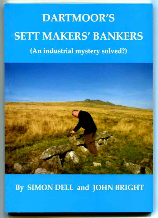
The story of sett makers and their bankers is told in this book .....

Book cover reproduced with permission.
The book that describes many aspects of granite working in this area.
Published by The Dartmoor Company, Okehampton. Tel. 01837 54727.
ISBN 978-0-9555150-1-9
The book has a list of the bankers and their locations on pages 73-77. My count from the book is that there are 77 locations on the slopes of the Staple or Steeple Tors and 112 actual bankers, counting the doubles, triples and quadruples.
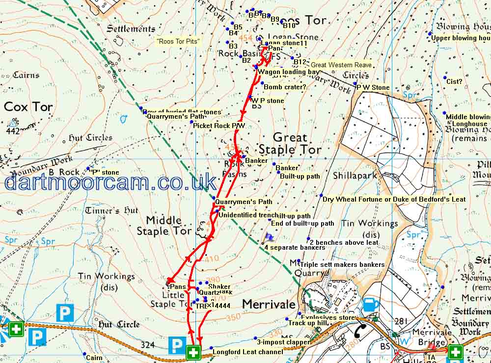
MAP: Red = GPS satellite track of the walk.

� Crown copyright 2016 Ordnance
Survey
Licence number 100047373
Also, Copyright � 2005, Memory-Map Europe, with permission.
This walk was easily reached via the road from Princetown to Tavistock road or the Tavistock-Moretonhampstead road (B3357). Parking was at the P symbol on the map with the white cross, just west of Merrivale.
Statistics
Distance - 4.11 km / 2.55 miles
All photographs on this web site are copyright © Keith Ryan.
All rights reserved - please email for permissions