

This walk: 2017-10-12. Fernworthy Forest, Grey Wethers stone circles, Sittaford Tor, Sittaford Circle, clapper bridge, Starkey Memorial Stone, Manga Farm, Marine Memorial Stone.
Walk details below - Information about the route etc.
Previous walks in this area: 14th December 2007, 5th August 2008, 7th October 2015 and 23rd March 2016
Google Satellite map + GPS track of the walk
Old maps
Ordnance Survey, Six-inch to the mile, 1842-1952 - showing
Teignhead Farm and Manga Farm to the north
Fernworthy Forest gate at SX 64395 83426, coffee stop after the walk from the car park.
View from the gate area to Sittaford Tor (at top right) and down to the paired Grey Wethers stone circles .....
Zoomed view.
Grey Wethers stone circles. Click the image for a larger view.
A section of one of the southern circle ..... it is noticeable how many of the stones are square-topped or angular .....
Section where the two circles almost touch .....
Looking back at Grey Wethers from the track that climbs up to Sittaford Tor .....
Zoomed view.
Sittaford Tor, SX 6331 8304, elevation 538 metres (1765 feet).
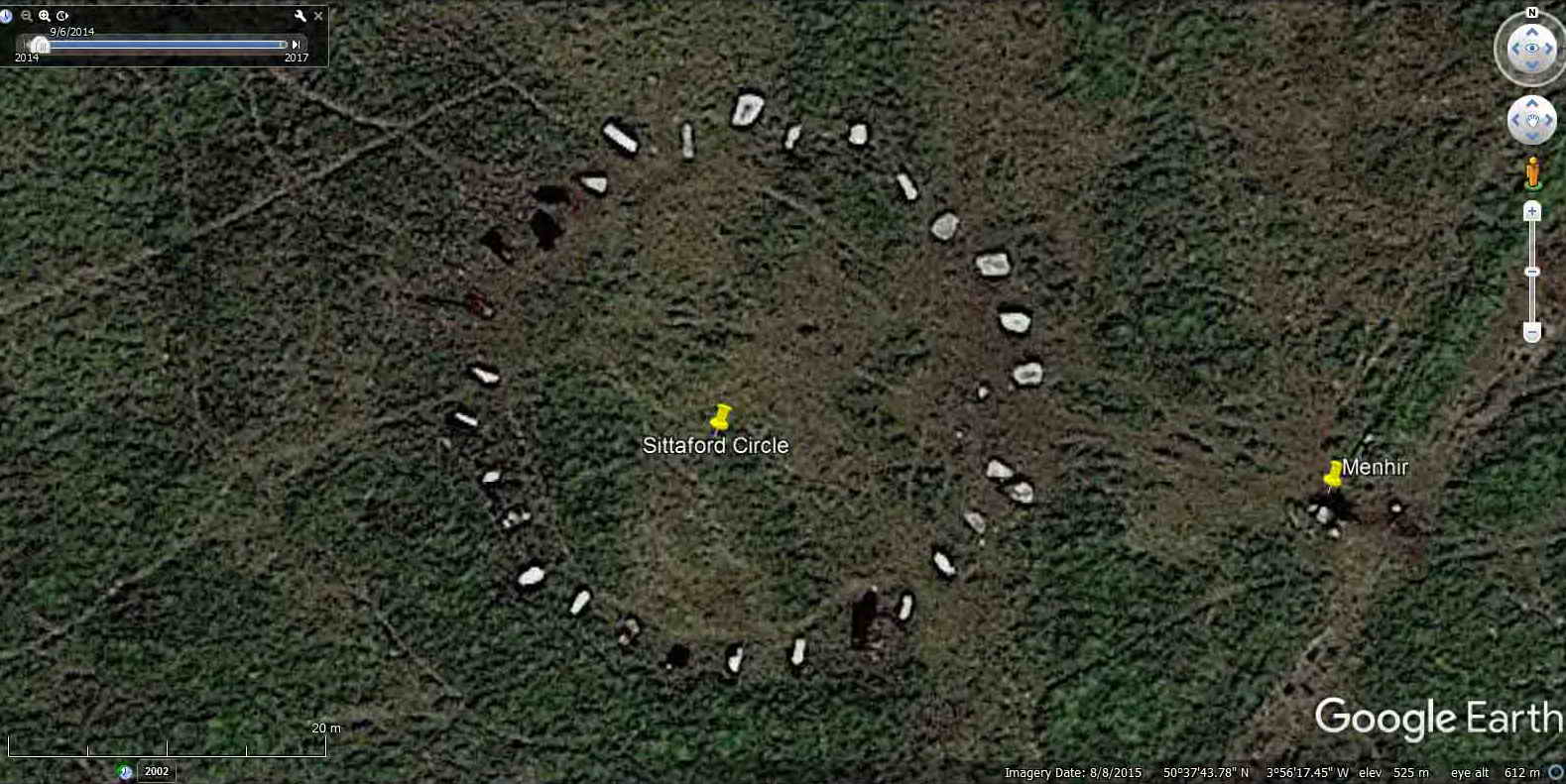
A leaning stone, or menhir, seen beside the recently-found Sittaford Circle .......
View from Sittaford Circle to the nearby menhir ..... the strange thing about this Bronze Age stone circle is that the stones, where present, are all toppled inwards towards the centre of the circle. The other point of interest is that, similar to grey Wethers, the stones seem to be quite angular .....
View to the menhir from the far side of the circle .....
View from Sittaford Circle to Sittaford Tor .....

Image from Google Earth (c) 2015. The Megalithic Portal link, Legendary Dartmoor link, Alan Endacott on Facebook (found the circle in 2007).
Sittaford Tor, there are three stiles around the tor, over the walls that butt onto it.
Distant view of Teignhead Farm.
Gateway near Teignhead farm .....
Zoomed view.

1840 Parish of Lydford (Forest of Dartmoor) Tithe Map showing Teignhead Farm, with Manga Farm (unmarked) to the north. The road running to the east is the road down to Fernworthy Farm, before the days of dam and forest. Permission: Devon County Council.
Clapper bridge at SX 64002 84640, with the Starkey Memorial Stone to the right, nearest the camera ..... Harry Starkey was a Dartmoor Guide and the stone is engraved "FHS 1912-1989" with an incised cross above. ..... 28 years of growth has all but obliterated the letters .....
There is another memorial to FS (Harry) Starkey on the reverse of the "new" Duke Stone on the boundary of Ilsington Manor at SX 7460 7730. This was done after Dartmoor Preservation Association asked Dave Brewer for a suggestion, remembering Harry as an Ilsington man. The original stone was believed washed away in floods in 1938; the new one was erected on 1th May 1993. The National Park recut the letters in 1998.
+
FHS
1912-1989
North Teign River, from the Starkey clapper bridge.
Approaching Manga Farm, at SX 63915 84856 ..... also known as Manga House or Mandles ..... this was a three-roomed house with a thatch roof. It was used as a squat in the 1980s, with tin roofing.
|
Dartmoor CAM movie. TIPS .....
A movie of Meldon Reservoir well and truly overflowing after the recently announced official drought! |
|
Click the photo to download |
Section of ruined wall .....
Water trough on the left as you reach the buildings .....
Fallen window lintel? There are two of these easily visible near where you first enter the site .....

Image from Google Earth (c) 2010.
The Marine's Memorial stone ...... in memory of a Royal Marine who died unexpectedly at or near this spot .....
RSM Perry was the Regimental Sergeant Major of the Commando Training Centre at Lympstone. At the end of a Royal Marine's commando training, the marine, as part of his unit, has to march for 30 miles with full equipment and the full unit has to complete the march in a set time. RSM Perry was overseeing one of these exercises when he had a heart attack and died. He was a very fit man and his death was unexpected. His family and friends placed the stone as a memorial to him at the spot where he died. The stone was originally upright but is now on its back.
Source: Moretonhampstead History Society Newsletter, April 2007.
See the following photographs for details .....
W.O.1. (RSM)
SL PERRY
ROYAL MARINES
12.11.49
20.10.92
IN MEMORY OF
WO1 (RSM) SL PERRY RM
12.11.49 - 20.10.92
The plaque is surmounted by the badge of the Royal Marines, with the motto Per Mare, Per Terram
The badge of the Royal Marines - somebody spent some time incising this .....
As previous photographs .....
Self-explanatory, from colleagues on HMS Minerva (F45), a Leander Class frigate that was decommissioned in 1992.
A separate plaque at the foot of the memorial .....
A final view.
The route from near the memorial stone back into the forest to reach a forest road. This was once cleared and appears as a track on the map, even with a small gate in the wall onto the open moor, but it has been replanted.
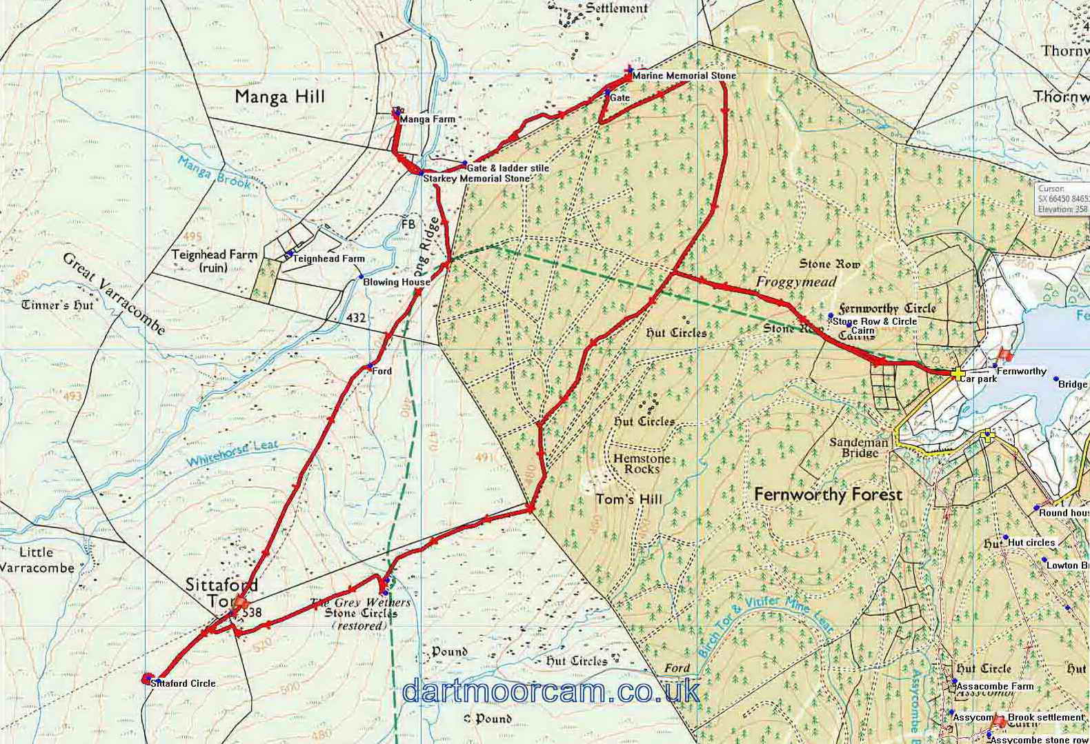
MAP: Red = GPS satellite track of the walk.

� Crown copyright 2016 Ordnance
Survey
Licence number 100047373
Also, Copyright � 2005, Memory-Map Europe, with permission.
This walk was reached by driving to the far end of the road around Fernworthy Reservoir., parking at the yellow cross.
Statistics
Distance - 10.9 km / 6.77 miles
All photographs on this web site are copyright © Keith Ryan.
All rights reserved - please email for permissions