|
F11 - Full screen F11 - Normal view Home & Contents |
|
"Alt" + � |
|||
This walk: 2013-5-30. Emsworthy Tin Mine, Emsworthy Lane, bluebells, granite posts, old sycamore tree, bracket fungi, sheep creep, Hound Tor, circular platform, semi-worked granite, granite tramway, Fitches' Holt, gymkhana, Holwell Lawn, Greator Rocks, Emsworthy West Quarry, Bagtor/Ilsington manorial bound stone, unfinished apple crusher.
Walk details below - Information about the route etc.
Link to Google Satellite view of the area - the car park is in the middle of the bottom edge of the image. Emsworthy Farm is a little to the "8 o'clock" position from the centre of the image.
This walk was a follow-up to the previous day's walk, on 29th May 2013.
A view of a filled-in pit by the road, part of the Emsworthy Tin Mine workings.
Emsworthy Lane, leading to Emsworthy .....
Carpet of bluebells, for which the area is well-known .....
Emsworthy Farm.
Granite posts that appear to run down the centre of a building? Note the notches in the post tops.
Old sycamore tree, measuring 4.36 metres (14 ft 3� ins) in girth about 1.25 metres off the ground, at SX 7458 7656.
Using the premise of 25 mm (1 inch) of increase in girth per annum in good growing conditions, this suggests an age of 172-174 years. If the tree is now "mature" and getting into old age, then it will not be growing so much, and in this case the tree could be older. Source: Paul Sterry (2007) Collins Complete Guide to British Tree, Harper Collins Publishers, page 24.
We have reported this tree to the Woodland Trust's Ancient Tree Hunt, the record can be seen by click on the following link .....
> You can view the details of your tree by navigating to http://www.ancient-tree-hunt.org.uk/recording/tree?tree=IQU5smjwpkaWmc9lswBD0Q.
Some other links .....
Another old tree was seen on one of our walks on 7 November 2012 near Drakeford Bridge.
Followers of this web site may be interested in the record of a recorded ancient tree in the car park at Postbridge: Tree 110530
An old window in the original longhouse.
Note the tree stump with bracket fungi and also the stump that is cut-off in the wall (at left) ......
Zoomed view of the stump in the ground.
Blocked sheep creep - the walls in this area are in very good condition.
A ground-level view of the as-yet-not-opened bluebells.
Hound Tor, with patches of bluebells.
The circular platform, at SX 74841 76988, described by Eric Hemery (1983), High Dartmoor, Robert Hale, London, page 735. This is the lower of two branches of the granite tramway that runs into the rock-field. There is also a tipping platform here, according to Hemery.
Another view of the platform, with a quarry area behind.
A collection of worked or semi-worked pieces of granite, including a section of tramway rail (at right).
Looking at both rails ot the Templer granite tramway .....
A section of tramway rail .....
The gauge seems to be 4 ft 3� ins.
A view along the tramway.
A small detached pile below the main summit, possibly this is the pile known as Fitches' Holt, 'fitch' being an old name for a polecat and 'holt' being their breeding place .....
Fitches' Holt, SX 74951 77070 .....
Fitches' Holt.
A view seen en route to Holwell Tor.
Zoomed view across the valley to a gymkhana, just above Holwell Lawn .....
Zoomed view to the bluebells of Holwell Lawn.
Greator Rocks, SX 747 786.
Looking down into Emsworthy West Quarry.
Bagtor / Ilsington manor boundary stone at SX 75169 76684.
xfs
Unfinished apple crusher at SX 74913 76436 (or very close to).
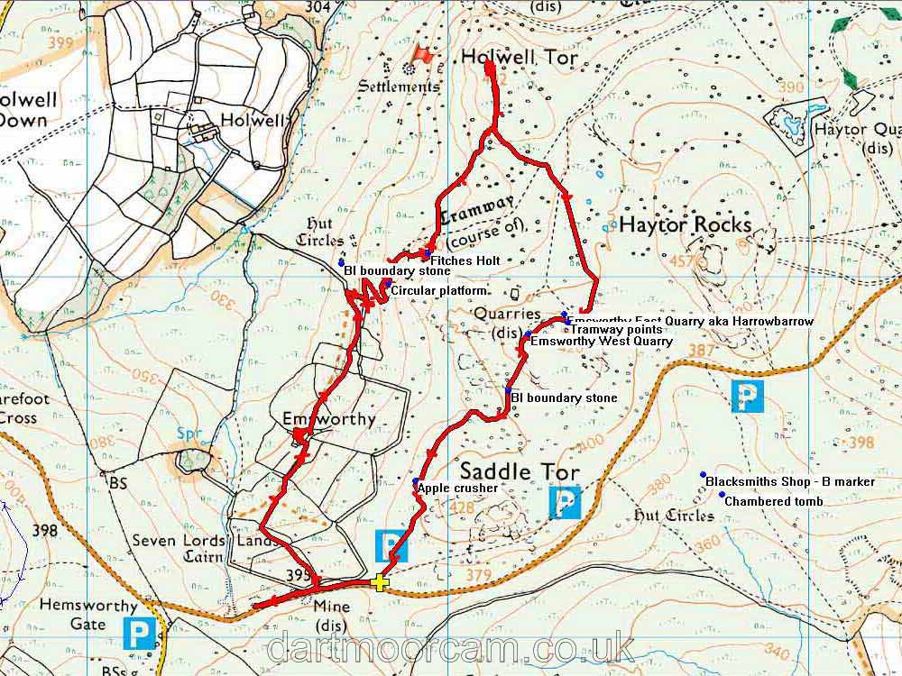
MAP: Red = GPS satellite track of the walk.

© Crown copyright and database rights 2012 Ordnance
Survey
Licence number 100047373
Also, Copyright © 2005, Memory-Map Europe, with permission.
This walk was approached via the A38 from Plymouth, Newton Abbot/Widecombe turn-off and following the road for Widecombe to Hemsworthy Gate where we turned right, towards Bovey Tracy, and stopping at the first car park on the left, the P symbol with a yellow cross on the map.
Statistics
Distance - 5.94 km / 3.69 miles.
All photographs on this web site are copyright ©2007-2016 Keith Ryan.
All rights reserved - please email for permissions
Dartmoor Tick Watch
The Cornish Pasty - The Compleat Pastypaedia
