


This walk: 2018-10-25. Sharpitor car park, Sharpitor, Leather Tor, cairn and cist, Stenlake Road, clapper bridge, Devonport Leat, Stanlake farm, Stean Lake stream, doll's head, Iron Bridge Aqueduct, River Meavy, Raddick Hill, Hart Tor Brook, crazing mill stone, Black Tor Falls waterfall, ruins of two tin mills, mortar stones, Cramber Tor, Black Tor Ford, capped boreholes, single and double stone rows with tinners' gully, Hart Tor, Black Tor, logan stone, blocking stone, double stone row half-buried in newtake corn ditch wall, bench mark, terminal cairns. D365-O7, O6, P6 & P7
Walk details below - Information about the route etc.
Previous walks in this area: 15th April 2009, 8th Sep. 2011, 3rd Sep. 2014.
Reconnaissance walks: 26th Sept 2018, 13th Oct. 2018, 20th Oct 2018, 24th Oct 2018
Google Satellite map + GPS track of the walk
Sharpitor, SX 560 703, elevation 410 metres (1345 feet) seen from the cist pictured below .....
Leather Tor, SX 563 700, elevation 380 metres (1246 feet) seen from the cist pictured following .....
Cairn and cist at SX 56430 70853, the name derives from "kistvaen" - a stone coffin, from from the Celtic cist, a chest, and maen, stone, v being used as a mutation of m. Source: Crossing's Guide to Dartmoor, 2nd edition 1912, reprinted 1990, page 22.
Closer view of the cist, illustrated by Brewer (see below) .....
A low-angle view of the cairn from the downhill side ..... showing how these burial sites can be seen .....
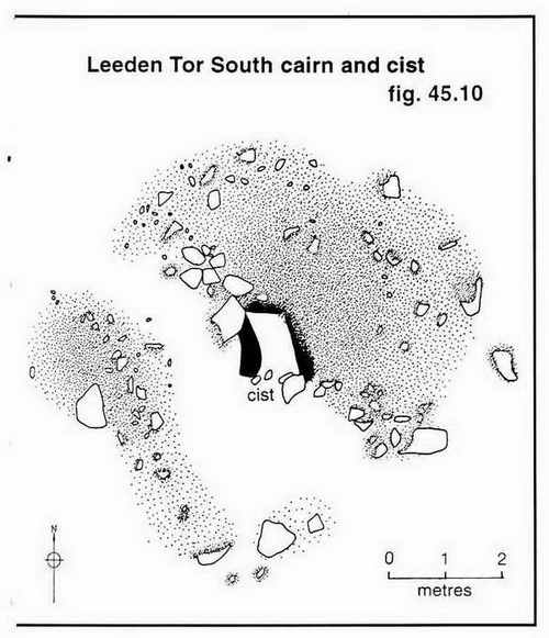
Image � J Butler
1994. Reproduced by kind permission (ref. 29 Sept. 2012)
The cist is described by Jeremy Butler, 1994, Dartmoor Atlas of Antiquities Vol. 3 - The South-West, 45:13: Sharpitor North-east double stone row and nearby cairns (fig. 45.10), pages 46-47. This cist can be found among Dartmoor Archive photographs labelled as Stanlake cist.
Devon & Dartmoor HER - MDV3746 - Round cairn 690 metres north-east of Sharpitor summit - Cist, good description, SX 564 708
Devon & Dartmoor HER - MDV3747 - Round cairn 685 metres north-east of Sharpitor summit - Nearby cairn, cist not exposed, SX 564 708
Looking south into Stanlake Plantation, recently clear-felled.
The right-hand bottom part of the photograph shows the narrow, sunken lane ("Stanlake road") that runs up the slope along the edge of the plantation and continued diagonally up and across the B3212 road as the old road to Routrundle. The clapper bridge over Devonport leat can be seen. Beyond this are the ruins of Stanlake, and beyond them is the Meavy valley and Raddick Hill.
Looking from across the clapper bridge up the sunken lane - this is quite narrow and "it is immediately obvious that it was built long before the the first wheeled conveyances were even seen in this part of the country. Indeed, it is so narrow in places that there seems hardly room to accommodate a laden packhorse." Also: "..... these rough moorland tracks were in fact the main thoroughfares in former times, and in 1823 the Walkhampton waywardens paid a local contractor, William Bickle, a penny (less than �p) per yard for repairing drains along the main highway along the stretch either side of what they called the Stenlake Road." Source: Mike Brown (2001), Guide to Dartmoor, CD-ROM, Dartmoor Press, Grid Square 567 709. Stanlake is dated to 1281 in one of the Historic Environment Records below.
A photograph taken on the clapper bridge looking north-eastwards along Devonport Leat towards the transmitter mast at North Hessary Tor.
Looking south into Stanlake Plantation, with Devonport Leat.
The gate into Stanlake Plantation .....
Close-up of the sign to Crossgate and Yennadon.
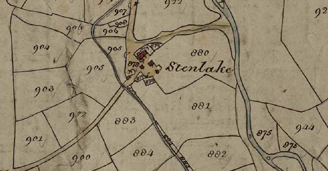
Stenlake Farm on the 1840 Tithe Map of Walkhampton Parish
Stenlake appears almost dead centre, with Ellisborough (Eylesbarrow) Tor out
to the right and slightly higher up the map.
(c) Devon County Council
OS 25-inch - single sheet, surveyed 1883, published 1885 - ends before the leat, cannot find equivalent adjoining single sheet the leat
OS 25-inch - seamless series, 1892-1914 - whole
area: also gives locations .....
North house, western half occupied by a later
building 50� 31' 14" 4� 01' 09" OR
-4.0191� 50.5205� OR SX 56958
70923.
South house,
50� 31' 14" 4� 01' 08" OR -4.0189 �
50.5204� OR SX 56978 70922.
From north house, 39 metres north to red building.
From north house, 18 metres south to red building.
Devon & Dartmoor HER - MDV20715 - Stanlake Farmstead, Walkhampton - a lot of detail
Devon & Dartmoor HER - MDV57155 - Longhouse at Stanlake Farmstead, Walkhampton - originally two longhouses across the slope
Devon & Dartmoor HER - MDV57162 - Drove roads at Stanlake Farmstead, Walkhampton - on the map these run N, E, and SW.
Devon & Dartmoor HER - MDV61992 - Leat in the Parish of Walkhampton - "new" leat from Devonport Leat to Stanlake Farm
Devon & Dartmoor HER - MDV57150 - Leat in the Parish of Walkhampton - leat from below Black Tor Falls to Stanlake Farm. Mentions new Stanlake leat after Devonport Leat was built.
Devon & Dartmoor HER - MDV28217 - Streamworks in the Parish of Walkhampton - no real description of this tinners feature, above Stanlake
I need to sort this out - the record says there were two longhouses across the slope, one being north of the other. The western half of the northern longhouse is occupied by a later building. The southern longhouse appears to have three outshuts. Both longhouses were replaced in post-medieval times by two other dwelling houses. Then the descriptions get a little involved. At least eight enclosed gardens or yards survive, some with sturdy walls to enclose livestock. It seems a third dwelling was constructed because "in 1683 the name John Warring first appears in the Walkhampton manor rentals, the occupier of what was therein named as a Third Part of Stenlake. Until about that time there had only been two Stenlake tenements ...." Source: Mike Brown (2001), Guide to Dartmoor, CD-ROM, Dartmoor Press, Grid Square 5698 7093. This third building is presumably one of the two ruins to the north of the main farm buildings.
Possible staddle stones - they are reported to be here somewhere but the stones here have been interfered with a lot. Staddle stones were set into the ground as a support for hayricks, so that the hay was off the ground and away from the rats and mices etc. Link to images .....
Overview of the possible staddle stones site, it is near the fence with the plantation and at the bottom end of the enclosures around the buildings..
I haven't worked out what this is yet - there were two longhouses, which were rebuilt, and then the house below was built but seemingly without note in the Historic Envirnoment Records above. Any suggestions would be gratefully received.
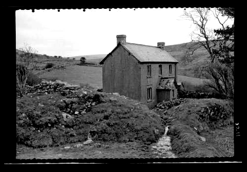
Stanlake farm house, 1935
Image
reproduced by kind permission of
Dartmoor Archive
See the Dartmoor Archive image online
here
The distant tree, just left of the house, is still there.
Details: This photograph shows the dilapidated state of Stanlake farm house in 1935. A closer inspection of the images highlights the loss of roof tiles from the porch. This farm house was a Plymouth City Water property and had been uninhabited for about ten years when this photograph was taken. This image was captured on the same day as other Taylor Collection images (31/03/1935).
I tried to "retake" the 1935 photograph, with limited success - I stood in the wrong place, but the various walls seem to have moved!. The large tree on the left is in the original photo. I think the distant tree in the left half of each photo might be the same. The large tree in the new photograph might be recent or hidden behind the house in the old photograph. The tree on the right edge in the old photo might be the decaying stump that is to be seen over the old wall today. I think the old photograph might have been taken almost from the clapper bridge over the Devonport Leat.
Sulphur Tuft fungus, Hypholoma fasciculare, growing on the roots/trunk of a tree stump.
Looking along Devonport Leat to an embanked section that crosses an old tin works and Stean Lake, a small stream - the name from Eric Hemery (1986), Walking the Dartmoor Waterways, David & Charles, Newton Abbot, page 21. Which came first, the name of the stream or the name of the farm? For those uncomfortable with slight heights, there is a low-level clapper bridge down to the left, at SX 56931 71032, at the edge of the photograph. There is also a route to the right of the leat to the clapper bridge in the distance.
Clapper bridge at SX 57157 71140 .....
Closer view, note the feather and tare marks.
Approaching the famous doll's head that was apparently set into the wall of the leat by a French prisoner-of-war during the Napleonic Wars. In the background is another clapper bridge, at about SX 5726 7134 (not recorded accurately) and to the left is a hawthorn tree. The doll's head is set into the bank right opposite the tree .....
The doll's head is seen halfway down the wall of the leat, just right of dead-centre .....
Closer view .....
Close-up details. Unfortunately the head has suffered after years of Dartmoor winters, freezes and some modern vandalism .....
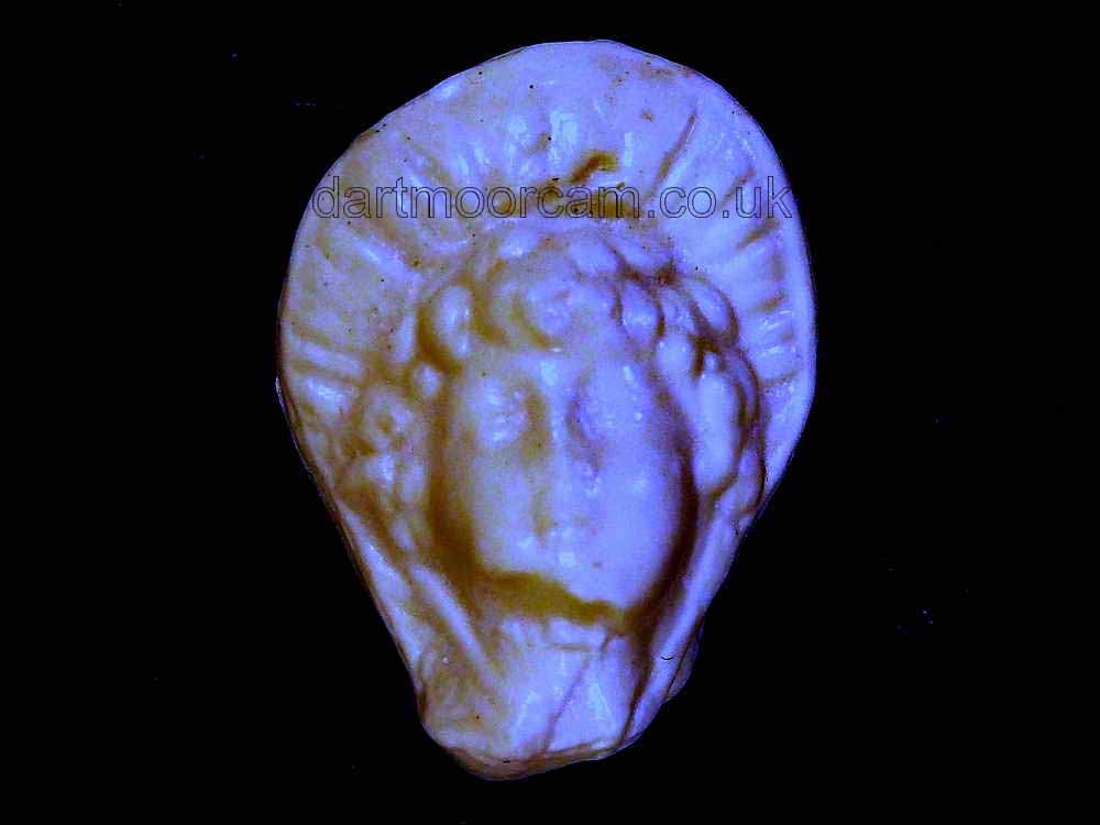
From Dartmoor CAM ....
A long time ago a porcelain "doll's head" was set into mortar in the wall of the leat about 100 yards along from the iron pipe towards Plymouth, in the north-west facing side. Hawkings (p. 54) calls it the 'Red Indian' or 'Turk's Head' and that it was probably placed here during repairs in the 1930s (should that be 1830s?) and that it was defaced in 1984. Robins (p. 72) says that it has an obvious indian head-dress and that it was put there by a French prisoner of war and is typical of the style of dolls at that time. I always thought it was a Red Indian feather head-dress (and not an Indian turban). Nowadays I think of it as a bonnet tied with ribbon. Dartmoor Prison took its first French prisoners from the Napoleonic wars (1803-1815) in 1809. In 1812, they were joined by American prisoners from the American War of 1812-1815 (the American War of Independence was 1775-1783). It could be from this era that a Red Indian head might have been fashioned by an American prisoner, but in porcelain? Lethbridge (p. 114) reports it being vandalised in the early 1990s. Mike Brown's Guide to Dartmoor (CD-ROM � 2001) says it was a Turk's Head and was replaced in 1996.
The story of the doll's head being replaced is that it was damaged after somebody had shot at it in the late 1980s/early 1990s. Luckily, a former Dartmoor Guide, Tom Gant, had made a cast of it and this was used to make three plaster replicas. Dartmoor was celebrating its archaeological centenary in 1994 (it being 100 years since the first official excavation by the Dartmoor Exploration Committee) and the National Park ran a competition in the free Dartmoor Visitor newspaper. It asked children what they would like to have buried with them in a cist. The winner was a schoolgirl, who spent a day with a DNPA archaeologist, the highlight of which was to place a replacement doll's head in the wall of the leat!
One source states the replacement was a resin duplicate made from a plaster cast of the original held by Peter Hirst, made by Tom Gant (Ted Birkett-Dixon mentioned it in 2000). The details of the story were in the local papers at the time. If the original head dated from 1812'ish, then it was in remarkably fine condition in about 1974 when I was first shown it by Tom Gant, after e.g. 150 or so years of exposure to the harsh elements of the Dartmoor winters. Another consideration is that when the leat was finished in 1801, it was an earthen ditch with cast-up banks for much of its course, it is difficult to discover when all the granite lining was put in place to preserve the banks and to reduce leakage, quite possibly long after the early 1800-dates mentioned above. Plymouth Leat was lined mostly in 1871 (Bush, p.20).
The photo above, of a resin duplicate, was taken in June 2011.
Books
David J. Hawkings (1987), Water from the Moor - An illustrated history of the Plymouth, Stonehouse and Devonport Leats, Devon Books, Exeter.
John Robins (1982 & 1984), Follow the Leat, Printed by Penwell Ltd, Callington / Tavistock.
William D. Lethbridge (2006), One Man's Moor, Halsgrove, Tiverton.
Ray Bush (2,000), Plymouth (Drake's) & Stonehouse Leats, Old Plymouth Society
Devonport Leat tumbles down Raddick Hill, over the Iron Bridge Aqueduct that crosses the River Meavy, and is fed by the iron pipe with water from the Meavy and Hart Tor Brook - this joins the Meavy not far upstream of this location. This is ironic considering that Devonport Leat was built in the 1790s because Plymouth would not share the water from Drake's i.e. Plymouth Leat. That leat was fed by the River Meavy with a head weir that is now under Burrator Reservoir and Devonport was not allowed to use its water.
Closer view.
Looking across the Iron bridge or Aqueduct and up Raddick Hill.
Another view of the Aqueduct.
Devon & Dartmoor HER - MDV51522 - 'Iron Bridge' aqueduct, Raddick Hill - aqueduct
The confluence of the River Meavy and Hart Tor Brook .... note what might be a crazing mill stone at the right, beside the water .....
Closer view of the possible crazing mill stone.
An upstream view of the confluence - Hart Tor Brook comes in from the left.
PASTSCAPE MONUMENT NO. 1461629 - Leat to Keaglesbourough Mine from the River Meavy below Hart Tor (with a feeder from Hart Tor Brook) that ran down the valley left side above a steep tinners' cliff. This leat is depicted in Butler Vol. 3, Map 46, p.87.
Zoomed view back to the Iron Bridge Aqueduct.
Devon & Dartmoor HER - MDV5020 - Tin mill in the Parish of Walkhampton - right bank, a lot of detail - the right bank of a river being on the right when looking downstream. This is a stamping mill with three double-sided mortar stones to be found, each being turned over and used again on the other side. There are signs of a fireplace in the north-west corner, away from the probable site of the waterwhell pit, which is nearest the camera in this photograph. The River Meavy and Black Tor Falls are in the background. The building was built using discarded mortar stones, suggesting that thuis is not the original mill.
Devon & Dartmoor HER - MDV57353 - Platform in the Parish of Walkhampton - flat area for dumping ore above the right bank tin mill
A view of the RH mill from the river bank.
Photographs in the Dartmoor Archive of the Black Tor blowing houses (it seems these were actually stamping mills and not blowing houses). There is a photograph of the furnace/chimney but it was plargely dismantled in the early 1900s to release a trapped colt.
Black Tor Falls.
Below the waterfall is a small iron "bridge" that affords access to the left bank stamping mill, seen above .....
Devon & Dartmoor HER - MDV28200 - Leat in the Parish of Walkhampton - Leat to tin mill & tinners gully through stone rows above Black Tor Falls
Devon & Dartmoor HER - MDV57351 - Leat in the Parish of Walkhampton - Leat to right bank tin mill. Other lost because it was wooden etc?
Double mortar stone with depressions worn by the constant pounding by the iron stamps used to crush the tin ore .....
Another view ..... ....
Similar view to the previous one but including the waterfall .....
View from the RH mill to the LH mill .....
The doorway on the in the south wall of the left-bank tin mill .....

Matthew
(4) & Lucy (2) sitting on the lintel, during a 1978 walk, 40 years ago.
Devon & Dartmoor HER - MDV5019 - Tin mill in the Parish of Walkhampton - left bank, across the river
LH mill lintel markings - XIII, suggested to be related to the registration of tin mills.
Preparing for the coffee break at the falls .....
The main group .....
Some were across the river .....
And some found their own quiet spot.
View from above the right bank mill (at lower left) across the River Meavy to the left bank mill .....
The left bank tin stamping mill (believed), no mortar or mould stones have been found. Interestingly, a crazing mill stone is seen about 100 metres downstream (see above).
View to Cramber Tor from above the waterfall .....
Cramber Tor, SX 583 711, elevation 418 metres (1371 feet).
Black Tor Ford at SX 57527 71678, beyond which is a tinners' gully that cuts through a double stone row that has a terminal cairn adjaent to another that is the terminal to a short single stone row. A capped borehole can just be seen in the grass just to the left of and above the large stone on the left edge of the track, this side of the water, and Hart Tor is seen on the left skyline .....
The capped borehole can again just be seen at the elft edge of the photograph, low down beyond the large stone. Looking upstrean there is a second simple iron bridge, beyond which are conifers at Princetown.
This image is presented here out of the 'taking' sequence - it was taken looking back from Black Tor (see later). It shows the double stone row running from near the bottom right corner (possibly a section is not in the photograph) towards top left to a terminal ring cairn. There is a second ring cairn to the right of the first one, almost touching. This is the terminal cairn of a single stone row that is shorter and runs almost horizontally perhaps halway across the photograph. Unfortunately, these stones are quite small and hidden in the grass. A tinners' gully cuts across the site, interfering with the rows.
Zoomed view across the ford to the double stone row, with the terminal ring cairn partially seen at the upper left edge of the photograph. The terminal ring cairn of the single stone row can be seen in the grass in the upper centre of the photograph.
The two terminal cairns, with stubborn cows that did not want to move when I got to them! The left-hand ring is the double stone row (running down to bottom right) and the smaller, less impressive ring on the right is the single stone row.
Looking along the double stone row with the terminal ring cairn at the top end, nearest the camera, SX 57719 71715. There is a 'pit', evidence of excavation (plundering) in the centre of the cairn. The downhill end of the row was recorded as being at SX 57588 71685, but this may be inexact, due to the tinners' disturbance. Butler (p.58) cites Wilkinson (1859) who surveyed the rows and recorded a fallen terminal stone, 25 feet long and 2 feet three inches wide (7.7 metres) in length which when erected must have been an impressive sight. The stone has since been removed - quite a feat in itself! In the language of the day, a double stone row is described as a parallelithon. The plundered pits in the cairns are described as evidently sepulchral.
Sources
Jeremy Butler (1994), Dartmoor
Atlas of Antiquities Vol. 3 - The South-West, 45.5: Hart Tor stone
rows and cairns (fig. 46.5, 5.1),
pp. 58-60.
J. Gardner Wilkinson (1862),
British Remains on Dartmoor in Journal Brit. Arch. Assoc.
xviii. pp.22-53, pp. 111-132. This reference has a diagram
(fig. 6 on page 48) that illustrates the row - I cannot find the 1859
source). The 1862 source is that cited in the Devon and Dartmoor
Historic Environment Record given with the diagram below.
Dartmoor Walks - Hart Tor Stone Row & Cairn Circle.
The terminal ring cairn at the uphill end of the single stone row, also with an excavated centre. The tall stone seems to the the near end of the row that runs away from the camera .....
This appears to the the terminal stone, downhill, at SX 57671 71676, of the single row. It may be that there are other stones hidden in the grass.

Image � J Butler
1994. Reproduced by kind permission (ref. 29 Sept. 2012)
Jeremy Butler, 1994, Dartmoor Atlas of Antiquities Vol. 3 - The South-West, 45.5: Hart Tor stone rows and cairns (fig. 46.5, 5.1), pages 58-60.
The site has one double and one single stone row. The double row is well preserved except for being interfered with by a tinners' gully and a leat.
Devon & Dartmoor HER - MDV4896 - Northern row of Harter group, Walkhampton Common - double, 137 meters long
Devon & Dartmoor HER - MDV4895 - Southern row of Harter group, Walkhampton Common - single, 50 meters long
Hart Tor, SX 581 720, elevation 390 metres (1279 feet) .....
Zoomed view to Hart Tor.
Another capped borehole with Black Tor beyond. The boreholes were drilled during surveys for the site of a new reservoir that resulted in the building of Burrator Reservoir (opened 1898) .....
Devon & Dartmoor HER - MDV62260 - Streamworks in the Parish of Walkhampton - Lode back tinwork 100 metres south-east of Black Tor
The capped borehole.
Black Tor, SX 573 717, elevation 360m (1181 ft) .....
Blak Tor .....
Black Tor .....
Looking across to the rocks of Leeden Tor.
Looking from Black Tor over Hart Tor to South Hessary Tor, SX 597 723, elevation 450 metres ( 1476 feet).
Logan stone at Black Tor, SX 57322 71818 .....
Black Tor and the Logan Stone seen from the south-west .....
Blocking stone at SX 57175 71528, at the end of a double stone row of which one row is incorporated and buried in the newtake wall .....
The row is 295 metres long .....
The newtake wall, which has a stone row inside it, is a corn ditch wall - these originate from the time when Dartmoor was a royal hunting area and there was a need to keep the King�s deer out of the cultivated land. A stone revetted wall and external ditch faced onto the open moor which deterred deer and other animals from jumping over, whilst the sloping grassy bank on the inner face allowed those animals which had entered to exit again without difficulty.
There is a gap in the wall at SX 57148 71509 and next to it (left, in this photograph) is a large stone into which is cut an Ordnance Survey benchmark B.M. 1128.6 .....
Closer view .....
Closer up.
Another view along the stone row .....
There are three terminal cairns surveyed at this western end of the row (see below), although it is possible that the newtake wall may have interfered with these.

Image � J Butler
1994. Reproduced by kind permission (ref. 29 Sept. 2012)
Jeremy Butler, 1994, Dartmoor Atlas of Antiquities Vol. 3 - The South-West, 46:14: Black Tor double stone row and cairns (fig. 45.11, 11.1, 11.2), pages 47-50.
Devon & Dartmoor HER - MDV4994 - Stone row 220 meters south-west of Black Tor - half-buried in Stanlake newtake outer cornditch wall
It was too tempting on this clear sunny day not to try a zoom or two to the transmitter station and mast at North Hessary Tor, SX 578 742, elevation 517 metres (1696 feet) .....
Zoomed view, the triangulation pillar is visible on the tor, towards the right edge of the photograph.
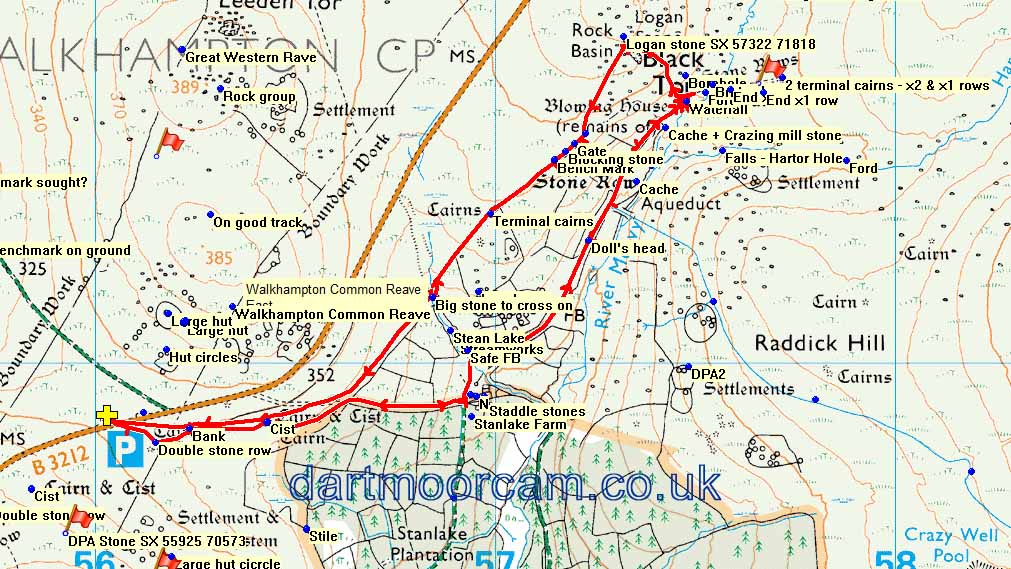
MAP: Red = GPS satellite track of the walk.
� Crown copyright 2016 Ordnance
Survey
Licence number 100047373
Also, Copyright � 2005, Memory-Map Europe, with permission.
This walk was reached from the B3212 Yelverton to
Princetown road, with car parking at the
P
symbol on the map, also marked by the left-most yellow cross.
Statistics
Distance - 4.4 km / 2.7 miles
All photographs on this web site are copyright
© Keith Ryan.
All rights reserved - please
email for permissions