|
F11 - Full screen F11 - Normal view Home & Contents |
|
"Alt" + � |
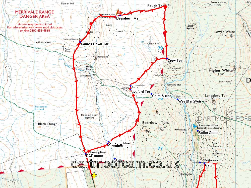
This walk: 2016-6-2. Holming Beam car park, Beardown Tors, Longaford Tor, observation hut, Crow Tor, Rough Tor, Devil's Tor, Beardown Man menhir, Conies Down Tor.
Walk details below - Information about the route etc.
Where we walked: Google Satellite view of the area - including the GPS track of the walk (compare with the Ordnance Survey map plus track below)
-
try zooming in with the mouse thumbwheel and "dragging" the map to see points of interest
-
click on the red place-markers to read their label - they are most accurate at the highest zoom level
-
try "mousing" over the list of placemarks on the left of the screen, highlights their place on the map
-
use browser back arrow or Alt key and left-arrow cursor key together to return to normal web page.
Previous walks in this area: 5th August 2009, 3rd February 2011 and 3rd October 2012,
Looking across the Cowsic Valley to Beardown Tors, SX 6027 7731, elevation 500 meters (1640 feet) ..... other names are Bairdown Tor and Bare Down Tor. Actually there are seven tors. Source: Ken Ringwood (2013) Dartmoor's Tors and Rocks, University of Plymouth Press .....
Cowsic bridge .....
Beardown Tors with passing heifers .....
Beardown Tor showing a firing range observation hut .....
Zoomed view .....
As previous photograph .....
Also showing (presumably) a stabling hut for a range officer's pony .....
Zoomed view.
Zoomed view to Longaford Tor, SX 61565 77931, elevation 507 metres (1663 feet).
Lydford Tor, SX 59915 78171, elevation 510 metres (1673 feet) .....
Climbing Lydford Tor .....
Lydford Tor.
The stile, north-east of Lydford Tor at SX 59907 78248.
Granite formation at Lydford Tor; horizontal bedding and vertical cracks.
Zoomed view to Rough Tor.
Crow Tor, SX 60632 78791, elevation 501 metres (1643 feet); also known as Crewtor and Crowter.
Looking back at Beardown Tors.
Grazing pony seen from Crow Tor .....
Crow Tor and grazing pony .....
Crow Tor .....
Crow Tor from another angle.
Grazing pony joined by friends!
Approaching Rough Tor .....
Rough Tor, SX 6061 7983, elevation 547 metres (1794 feet) ......
Rough Tor .....
Rough Tor firing range observation hut .....
Rock formation adjaent to Rough Tor.
Featureless landscape north of Rough Tor.
Devil's Tor and Beardown Man .....
Zoomed view .....
Devil's Tor, SX 59612 79630, elevation 549 metres (1801 feet) with horizontal jointing, making it a lamellar tor .....
Beardown Man, a standing stone or menhir, 3.5 metres (11 feet 4 inches) high: the tall menhir at Drizzlecombe is 3.2 metres (10 feet 6 inches) in height .....
Beardown Man .....
"From the rim of the Cowsic Head Basin, a pointing finger of stone is seen to dominate the upper easst valley side. A monolith unassociated with any other monument, this is the Bronze Age menhir called Beardown Man. Standing 11 feet 4 inches in height, it appears, when viewed from the south to be of great bulk, yet when viewed from the south-east it is as slender as a butter knife."
Source: Eric Hemery (1983), High Dartmoor, Robert Hale, London, pages 400-401.
Ron, as a 6ft 3 ins. scale .....
Keith, as a 5ft 8 ins scale .....
Beardown Man and Devil's Tor scene .....
As previous photograph, showing the thinness of the standing stone.
The Cowsic River valley head.
Hare's tail cotton grass, Eriophorum vaginatum, single seed head ..... the alternative is Common cotton grass, Eriophorum angustifolium, with several seed heads.
Looking back at Beardown Man and Devil's Tor.
Conies Down Tor, SX 58902 79121, elevation 533 metres (1749 feet) ..... cony is an old word for rabbit .....
Looking back at Conies Down Tor.
MAP: Red = GPS satellite track of the walk. NB - It is adviseable in after wet weather to contour north of the "Conies Down Tor" label on the map around the head of the valley. It can be very boggy otherwise.

© Crown copyright and database rights 2015. Ordnance Survey
Use of this data is subject to terms and conditions.
Also, Copyright © 2005, Memory-Map Europe, with permission.
This walk was reached by driving up the long side road off the Tavistock-Two Bridges road alongside the Long Plantation and parking at the yellow cross = Holming Beam car park.
Statistics
Distance - 9.79 km / 6.08 miles.

