|
F11 - Full screen F11 - Normal view Home & Contents |
|
"Alt" + � |
This walk: 2016-1-27. Grenofen Bridge, River Walkham, salmon ladder, leat headweir, buddles, Walkham United Mine ruins, Gem Bridge, gorse blossom, moss fruiting bodies, oak tree, Dartmoor ponies, memorial bench, bracket fungus.
Walk details below - Information about the route etc.
-
OS Six-inch to the mile, 1884 - shows Walkham United Mine (copper, disused).
-
OS Six-inch to the mile, 1883 - see top right corner
-
OS Six-inch to the mile, 1884 - extends to Bedford Bridge, Wheal Franco & Horrabridge.
Where we walked: Google Satellite view of the area - including the GPS track of the walk (compare with the Ordnance Survey map plus track below)
-
try zooming in with the mouse thumbwheel and "dragging" the map to see points of interest
-
click on the red place-markers to read their label - they are most accurate at the highest zoom level
-
try "mousing" over the list of placemarks on the left of the screen, highlights their place on the map
-
use browser back arrow or Alt key and left-arrow cursor key together to return to normal web page.
Previous walk in this area: 26 Jan. 2011, 6 Nov. 2011 and 28 March 2012 & 4th May 2012.
The fast-flowing River Walkham, just upstream from Grenofen Bridge, after a lot of rain .....
A combined salmon ladder and headweir for the local mine, with the weir extending across the river, perhaps now falling into disrepair .....
Another view .....
Dartmoor CAM
movie. TIP .....
A movie of a fast flowing River Walkham, after a lot of rain. |
Click the photo to download File size: 2.9 MB. Length 16 secs |
Probable remains of a puffball fungus, reminiscent of an earth star.
Water flowing over a fallen tree .....
Zoomed view.
One of the old buddles of the Walkham United Copper Mine .....
Another buddle.
The path sometimes featured tree roots, making it a little difficult.
More mine remains .....
Zoomed view.
An old leat, now acting for drainage.
Another view - the white blobs on following photographs are rain drops on the camera lens.
Gem Bridge - a new link!
Gorse flowers in the rain.
Moss fruiting bodies in the rain, on the parapet of Screw Bridge.
Caption from 24th May 2012: "A Common, English or Pedunculate Oak, Quercus robur. The flower and acorn are on a stalk called a "peduncle" whereas on the sessile oak, Quercus petrea, they are borne directly on the twig. In this oak, the leaves have small basal lobes where they join the stalk which are absent in the sessile oak."
Dartmoor ponies hunkering down against the wet weather .....
1 - 2- 3 - nuzzle!
Pony eating gorse - I've been waiting to get a movie of this for years ..... for the people who say they don't .....
Memorial plaque on a bench .....
A small group of the hardiest souls today, at SX 49156 69848, complete with rain drops on the camera lens.
A sunken lane aka hollow way or holloway?
Sheltering under a bracket fungus .....
It is a large bracket, not sure if this was a birch tree, it looks like it might be from the twiggery in the previous photograph, in which case this would probably be a Birch Polypore, Piptoporus betulinus.
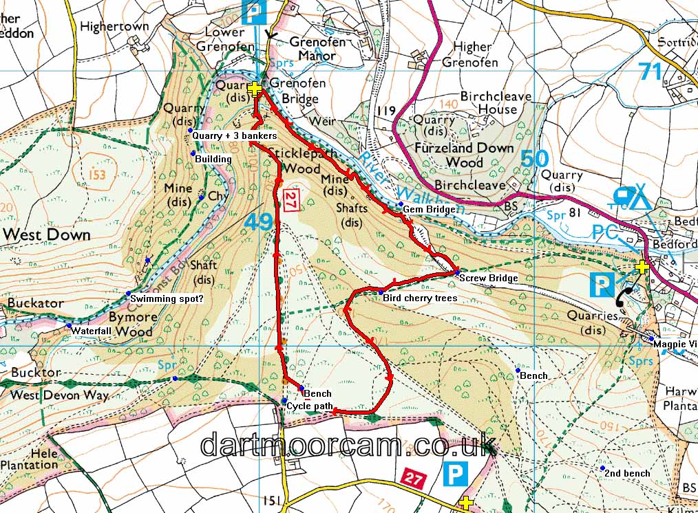
MAP: Red = GPS satellite track of the walk.

© Crown copyright and database rights 2015. Ordnance Survey
Use of this data is subject to terms and conditions.
Also, Copyright © 2005, Memory-Map Europe, with permission.
This walk was reached via the road from Yelverton to Tavistock, turning left opposite Drake's Cafe (formerly The Halfway House Inn) and taking the first road left (not the private drive) and parking at the end, over the bridge, indicated by the P symbol and the yellow cross on the map - at centre top.
Statistics
Distance - 3.66 km / 2.27 miles.


