|
F11 - Full screen F11 - Normal view Home & Contents |
|
"Alt" + � |
This walk: 2015-4-22. Drilled stone, hut circle, Butter Brook, blowing house, Tor Rocks Quarry, 2nd quarry, Puffing Billy Track, Hangershell Rock, Butterdon Rifle Range 700-yard marker stone. Also, Spurrell's Cross, observation pits and rifle range butts (firing points) seen on the "recce".
Walk details below - Information about the route etc.
Google Satellite view of the area - including the GPS track of the walk (compare with the Ordnance Survey map plus track below)
-
try zooming in with the mouse thumbwheel and "dragging" the map to see points of interest
-
click on the blue place-markers to read their label - they are most accurate at the highest zoom level
-
"mousing" over the list of place-marks on the left of the screen, highlights their place on the map
-
use browser back arrow or Alt key and left-arrow cursor key together to return to normal web page.
Similar walk in this area: 2nd May 2012.
Old maps: (1) Ordnance Survey 6-inch, 1886, (2) Ordnance Survey, 6-inch, 1888-1913, and (3) OS 1:25,000 1937-1961
Notice inside Harford Moor Gate - click the image to see a larger version.
Drilled stone at SX 64432 59337, among the hut circles, where someone has either been testing drills for sharpness or simply improving their drilling skills; one odd aspect is that some holes are not just round - especially the bottom left hole.
Just to prove a point ..... some of the holes are quite deep .....
Everyone wants to make sure!
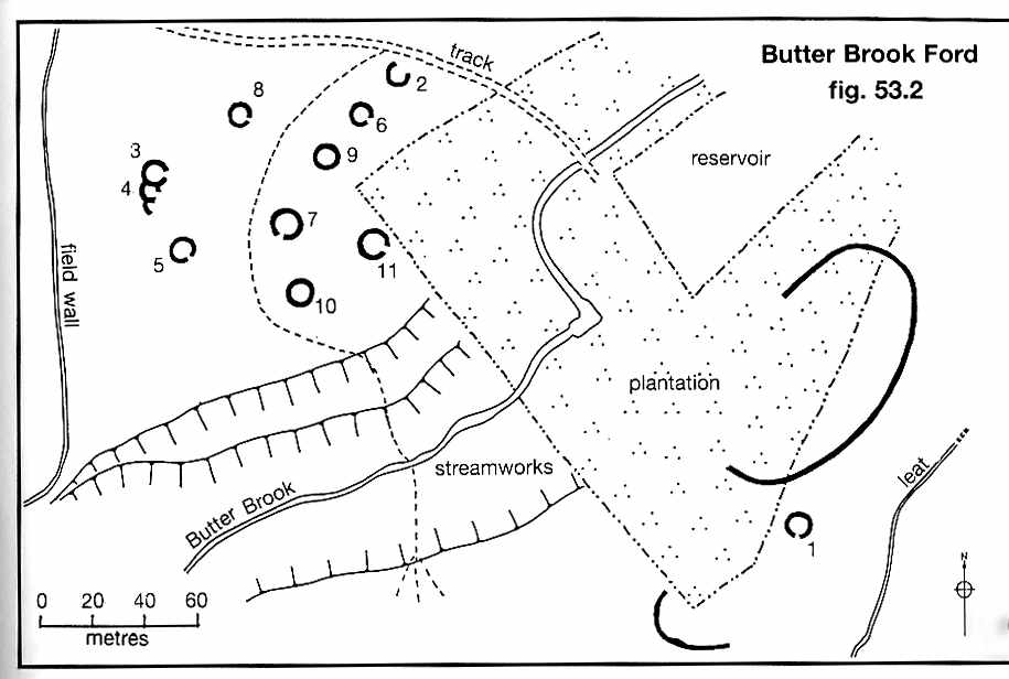
Hut 10 (see the figure below), with Butter Brook Ford behind (at left) and a view of the tinners' stream-works area .....
Hut circle with double walls, SX 6445 5929 ......

Image © J Butler
1993. Reproduced by kind permission (ref. 29 Sept. 2012).
The settlement is described by Jeremy Butler (1994), Dartmoor Atlas of Antiquities, Vol. 4, 3: Butter Brook Ford (fig. 53.2), pages 18-19. This Bronze Age settlement has been disturbed by tinners and their early stream-works and in recent times by the building of the modern reservoir. The Harford Moor Gate - Broomhill and Addicombe track can still be seen crossing the Butter Brook at Addicombe Ford and stepping stones. Another shallow crossing place can be found approximately where the "20" occurs on the scale bar.
Butter Brook ..... old name: Buter Broke = "the brook of good pasture" .....
Butter Brook.
A drilled rock, using feathers and tares, some of which are stuck in the rock.
Stepping stones in Butter Brook, near SX 64375 59220 .....
The stones, showing their proximity to another shallow ford .....
The second ford showing another Broomhill track.
Looking upstream, Butter Brook .....
Looking downstream, Butter Brook.
Hanger Down Clump, visible for many miles around.
Zoomed view to Tor Rocks, there is a quarry here ..... Tristis Rock should be visible from here to the north-west.
Looking at the blowing house, that later became a smithy for the quarries, at SX 64213 59210 ..... as a blowing house, recorded as Butterbrook Mill, it is believed to pre-date 1750 ..... there seems to be no sign of a leat and wheelpit mentioned elsewhere .....
Closer view ..... the right-most stone just outside the house is the mould stone .....
Eric Hemery (1983), High Dartmoor, Robert Hale, London, page 260, quotes R. Hansford Worth when he was editing the Andrews Papers when he said the blowing house "was used a s a smithy when the3 quarries were worked at Tor Rocks" and continues .....
"In 1940 I found some heaps of scoria, which I first identified as tin-slag, but had, on closer examination to recognise as a clinker from the smithy. There are also two earthfast stones which my wife discovered, and these have been used either for testing the edge of quarry tools or in practise in the use of jumpers. The remains of the building give the appearance of old work, and the question has been how far it far it is the original blowing house or how far it was altered when converted into a smithy"
Mould stone .....
Looking down on the mould stone .....
Near the mould stone, a drilling practice stone, either for testing the efficacy of serviced drills or for jumper practise - or the effects of rock-worm.
Showing the proximity of the drilled stone (at bottom) and the mould stone (near front at right edge) to the main part of the blowing house/smithy.
Tor Rocks again.
Nearby sign .....
Broomhill Leat take-off .....
Broomhill Leat.
Tor Rocks Quarry ..... to the left, part of a large crane base ..... the quarry provided stone for the building of Butterdon Reservoir in 1916, to supply Ivybridge. Latterly, it only supplied Harford and outlying dwellings. In 1994, an EU Directive meant that it had to be closed due to the high amounts of aluminium in the water. It was sold by SWW in 2009.
Crane base .....
Another view.
Crane base lecture .....
Making a point!
Opposite the quarry, a strange enclosure .....
As previous photograph, with a sturdy wall surrounding a pile of stone, why?
The track away from the quarry .....
Another look at Tor Rocks Quarry .....
At SX 64028 59043, a grass track leads up left to a second quarry (SX 64070 59040), about 100 metres south of the 1st quarry, this manifests an interface between Devonian rocks .....
Illustrating a vein of a different rock .....
As previous photograph.
The rock here is not granite; it is either ....
(1) Middle Devonian Slates - Metalimestone. Metamorphic Bedrock formed approximately 385 to 398 million years ago in the Devonian Period. Originally sedimentary rocks formed in shallow carbonate seas. Later altered by low-grade metamorphism, or
(2) Middle Devonian Slates - Slate, Hornfelsed. Metamorphic Bedrock formed approximately 385 to 398 million years ago in the Devonian Period. Originally sedimentary rocks. Later altered by high temperatures of igneous intrusion.
Unfortunately it is difficult to ascertain the exact location on the geological map made available by the British Geological Survey. through this app.
Another well-drilled piece of stone, in this second quarry.
Zoomed view to Tristis Rock (see 3rd April 2013), also known as Hall Tor, at SX 6382 6015.
The walk proceeded to climb to the dismantled Redlake tramway - see Redlake Tramway walk - 25th April 2011 - 24 km (14.92 miles) for details of the tramway or "Puffing Billy Track"- so-called because of the small steam railway locomotives that were used to pull trucks to Redlake from Cantrell (near Ivybridge).
"The Redlake Tramway commenced on the edge of nowhere and terminated right in the middle of it", EA Wade, 1982.
| Some
background ..... Source: EA Wade, 1982, The Redlake Tramway and China
Clay Works, Twelveheads Press, Truro.
1846, South Brent Peat and Peat Charcoal Works
established at Shipley Bridge to extract naphtha from peat (p.11). 1850, Leftlake china clay works first opened in
about 1850 (p.8). 1872, Brent Moor Clay Company formed. Worked former Knattabarrow clay works, became known as Petrie's Pit, close to the old Zeal Tor Tramway. A branch line was built and the old naphtha works converted to clay dries. Abandoned 1880 (p.13). Re-opened 1923 by then-owner of Redlake works, this seems to have been short-lived. 1911, The Redlake Tramway was opened 11 September
(p.23). |
The 700-yard marker stone on Lane 1 (actually Lane D?) of the Butterdown Rifle Range, SX 65472 59568, constructed from Oct. 1860 and used between April and July 1861. The short life was due to a law suit being brought against "the officials" for failing to press claims for rights of certain individuals, also the range was built on Harford Moor when permission was only given for construction on Ugborough Moor. Source: Dave Brewer, The Butterdon Rifle Range, Dartmoor Magazine, no. 145, Winter 1996, pages 10-11. One trusts that the shooting was accurate - especially with Observation Pits being 100 yards in front of the Butts i.e. Firing Positions, Health & Safety, anyone? I wouldn't want to poke my head up in that situation to observe targets with shooters directly behind me. This range was used a few years after the Crimean War (1853-1856) and well before the Battle of Rourke's Drift, 22nd & 23rd January 1879 and the Battle of Islandlwana, 22nd January 1879 in the Anglo-Zulu War but they were the times under consideration with regard to this very short-lived rifle range. To see what else was happening in the world in 1860-1861, click HERE.
Showing the proximity of the range marker to the Redlake Tramway, with Hangershell Rock behind.
Zoomed view looking north, up the Erme valley, with Stall Down (left) and Sharp Tor (right).
Inspection manhole in the Redlake-Cantrell pipeline that transported china clay slurry off the moor for drying etc. An intact cover can be seen on the 25th May 2011 web page, and a view inside a different inspection pit can be seen on the 28th April 2011 walk.
THE FOLLOWING PHOTOGRAPHS WERE TAKEN ON THE "RECCE"
Hangershell Rock, SX 6549 5935, about 100 m east of the tramway .....
SX 65648 59850 - an unusual earthen platform constructed beside the tramway.
One of the longest stone rows on Dartmoor crosses the railway track.
"It's twins!"
Spurrell's Cross, part of the momk's route from Buckfast Abbey to Plympton Priory ..... looking eastwards to Brent hill .....
Looking westwards, low-angle photograph .....
The damaged cross, missing one arm: unusual in that it is the only cross on Dartmoor to have two spurs on each arm.
Dew pond beside the track at SX 65798 60054 .....
View across what is left of the pond, to Spurrell's Cross, with Ugborough / Eastern Beacon beyond - with cairns.
Observation Pit, Lane 4 (nearest tramway), SX 65642 60255 .....
Observation Pit, Lane 3, SX SX 65548 60206 .....
That long stone row again ..... with Hangershell Rock at top right.
Observation Pit, Lane 2, SX 65462 60160 .....
Looking back 100 yards to the Butt, Lane 2, .....
Butt (Firing Position), Lane 2, SX 65455 60235 .....
Firing Position, Lane 1, SX 65366 60191.
Hangershell Rock, from a long way off, near the end of the walk - looking across some of Butterdon Rifle Tange (1860-1861).
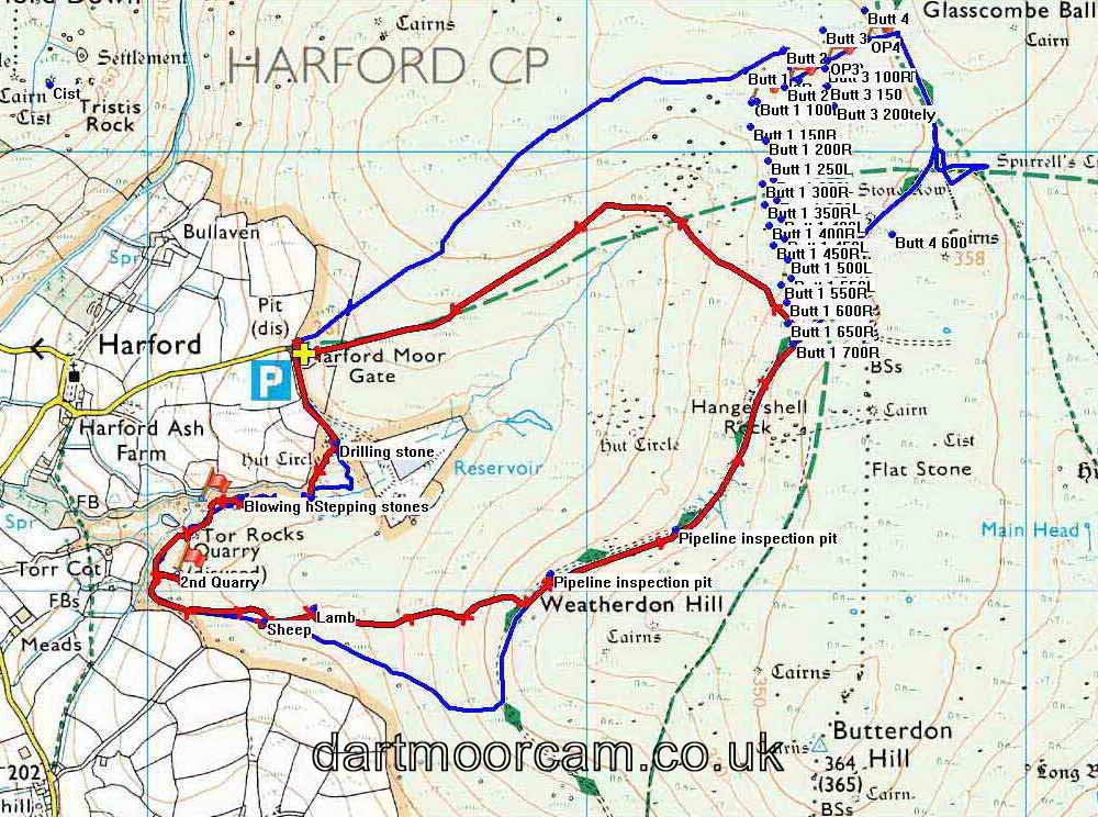
MAP:
Red
= GPS satellite track of the Wednesday walk,
Blue = GPS track of the
Monday "recce" ......
The walk was shortened because of time spent dealing with a
sick sheep and the strong wind that blew constantly.
The many blue marker dots indicate the positions of range marker stones on the
Butterdon Rifle Range from an earlier walk.

© Crown copyright and database rights 2015. Ordnance Survey
Use of this data is subject to terms and conditions.
Also, Copyright © 2005, Memory-Map Europe, with permission.
This walk was reached from Plymouth via the A38, exiting at Lee Mill. The road is good until you leave Cornwood, then it becomes a single track road, with passing places. From Cornwood, it is three miles of narrow lanes to Harford. There is a similar approach from the eastern end of Ivybridge. On entering Harford you need to turn left (from the Cornwood direction) after the church and drive up the narrow lane and go through the gate onto the moor, parking just inside the gate, at the yellow cross / P symbol on the map.
Statistics
Distance - 4.83 km / 3.00 miles.

