|
F11 - Full screen F11 - Normal view Home & Contents |
|
"Alt" + � |
This walk: 2015-1-21. Dartmoor ponies, frozen cycle track, lumpy ground, Cox or, Great Staple Tor, Great Mis Tor, benches, memorial plaques, bomb handling ramps, building bases, signal square, compass platform.
Walk details below - Information about the route etc.
Other walks in this area: 1st July 2009 and 17th Oct. 2012.
Other walks going onto Roborough Common/Clearbrook area, started from near Roborough Rock on 28th Nov. 2012 and 31st Jan. 2013, visiting just the corner of the airfield nearest to Plymouth.
Most of the photographs below were taken during a "recce" on 28th Dec. 2014, which was a cloudless, freezing day.
The starting area for today's walk, with long shadows - this was the WW2 airfield known as RAF Harrowbeer: there is also an RAF Harrowbeer 1940s Event 2015 web site and an RAF Harrowbeer Facebook page.
Dartmoor ponies finding breakfast.
Entering a scrubby area.
Frozen pond.
Looking along the cycle track - the idea was to capture the glinting ice crystals that were quite spectacular, but the attempt failed .....
Another attempt at the ice crystals, this also failed.
A very "lumpy" ground area, possibly as a result of mining activities.
The road alongside (west) of the main road where it "kinks" at the very top end of Horrabridge.
More lumpy ground.
Road junction where across leads into The Old Station .....
Another view .....
The sign.
Sheep seen along the way, with a little back-lighting.
The path ahead.
Out on the Down.
View to Cox Tor, SX 530 761, elevation 442 metres (1450 feet), Great Staple Tor, SX 542 760, elevation 455 metres (1492 feet) and Great Mis Tor, SX 563 769, elevation 538 metres (1765 feet), with Pew Tor in front - to the right, SX 532 734, elevation 318 metres (1043 feet) .....
Great Staple Tor .....
Similar view.
Bench at SX 50247 69556 ..... (Bench no. 2 on a previous walk .....
In memory of a local midwife and a health worker (known to some on the walk).
Seen on the short uphill turn-around part of the walk.
Another bench ("Bench 3") at SX 50513 69212 .....
Closer view .....
The memorial plaque.
Panorama from Cox Tor (left), Great Staple Tor, Pew Tor, Great Mis Tor, King's Tor, Swelltor Quarries, North Hessary Tor, Ingra or Leeden Tor?, Princetown trees, South Hessary Tor, Sharpitor to Peek Hill (right). Click the image to see a larger LABELLED version.
Pony.
Curious pony.
The remains of an old airfield building.
This pony was grazing on the gorse .....
It wasn't eating the dead bracken - I made a video but it failed to save.
Bomb-rolling ramp between the trees .....
Bomb ramp .....
Area behind the bomb ramp - the ramp is seen at extreme top left corner in this photograph .....
Turning slightly right from taking the previous photograph - there is the remains of a wide track, a road or railway?
A second ramp, at the far end of the first ramp photograph above .....
Looking right, at the first ramp .....
There is another straight track (road / rail?) on this side of the bomb-handling ramps.
More building bases .....
Another set of foundations .....
Part of a "circle" area shown on the map, now accessible for car parking .....
More foundations .....
Display board. Click the image to see a larger version.
One of several temporary ponds in the area, this one at SX 5083 6830, of the sort in which the fairy shrimp (Chirocephalus diaphanus) might be found.
From the Dartmoor National Park Authority Habitat Action Plan for Freshwater .....
"The fairy shrimp Chirocephalus diaphanus is a crustacean which occurs in pools that dry up from time to time, such as rutted tracks and gateways. It can be found in a few areas along the south-western fringes of Dartmoor. It is nationally uncommon and protected under the Wildlife & Countryside Act."
More building bases .....
Looking the other way/
Just a frozen pool.
The remains of what appears to have been a building with many rooms.
Getting back towards the car park .....
The Signal Square ......
From the RAF Harrowbeer web site .....
"The Signals Square was situated close to the Watch Office. On an airfield the runway-in-use for landing and take-offs was dependant on the wind direction. For an aircraft coming in to land a "Landing Tee" would be positioned in the Signals Square pointing in the approximate direction. There would also be a second "Tee" positioned at the downwind end of the runway. The crossbar was always nearest to the approaching wind."
The Compass Platform .....
Walking group on the Compass Platform.
John, telling the story of the "Polish Memorial" as it is kniown to some, it is a memorial to all the pilots who flew from RAF Harrowbeer during WW2 .....
The stone was a piece of granite from the Foggintor/Swelltor quarries that was cut for building into Plymouth Breakwater (built 1812-1814). The piece fell from the Tyrwhitt Tramway on Roborough Common and lay there until 1981, when it was airlifted by helicopter to this spot .....
The inscription (photograph taken 20th Oct. 2012 for inclusion in the web page for the walk on 17th Oct. 2012).
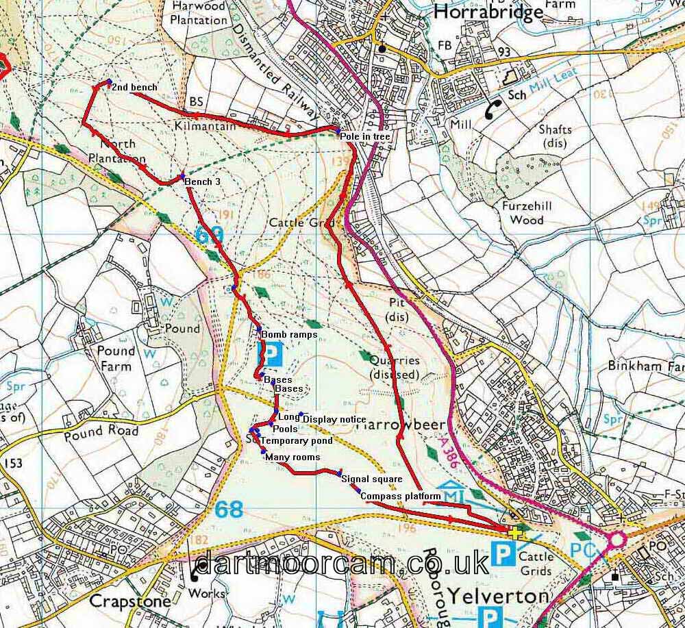
MAP: Red = GPS satellite track of the walk.

© Crown copyright and database rights 2014. Ordnance Survey
Use of this data is subject to terms and conditions.
Also, Copyright © 2005, Memory-Map Europe, with permission.
This walk was reached turning left on the Plymouth-Yelverton road just before the Yelverton roundabout, driving onto the Common and parking on the right (at the yellow cross) just after the cattle grid. The P symbol on the map denotes a Pay & Display car park that you pass on the way, just before the cattle grid.
Statistics
Distance - 5.73 km / 3.56 miles.


