|
F11 - Full screen F11 - Normal view Home & Contents |
|
"Alt" + � |
This walk: 2014-5-7. Hound Tor, Swallerton Gate, Swallerton Gate Cross, granite trough, Dexters, Bowerman's nose, bluebells, Dartmoor white-faced sheep, dung bonnets, Manaton Church, pennywort, lichen, lousewort, Blissmoor longhouse, pink purslane, Jay's Grave.
This present page gives full screen height photos on pc's with most browsers. It can be a problem on Apple devices - if so, click the Apple-page link.
![]() Link to mobile device version of this web page
- with fixed photo dimensions.
Link to mobile device version of this web page
- with fixed photo dimensions.
Walk details below - Information about the route etc.
Link to Google Satellite view of the area - including the GPS track of the walk (compare with the Ordnance Survey map plus track below)
Previous walk in this area: 12th Aug. 2009.
Hound Tor, SX 742 789, elevation 414 metres (1358 feet), photographed from the road approaching from Harefoot Cross .....
Hound
Tor seen from the Swallerton Gate car park.
Swallerton Gate Cross, the head of a medieval cross that was found in rubble and is now placed in a garden wall .....
Closer view, showing the inscribed cross within the cross head stone .....
The cross can be seen near the centre of the photograph ..... behind the fence .....
The house that was a cider house called the Hound Tor Inn until 1840, frequented by travellers in the early wool trade.
Granite drinking trough.
Nearby barn .....
Bowerman's Nose, in the distance .....
Zoomed view.
English bluebells - very stunted in this exposed area.
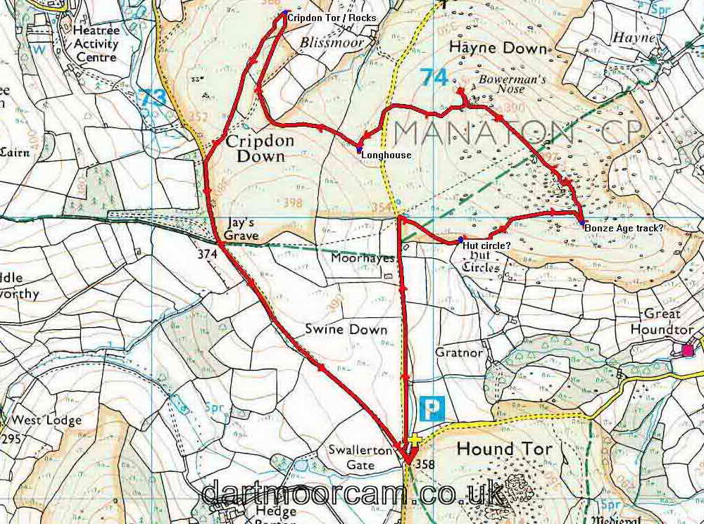
Possible hut circle at SX 74098 79919 .....
Looking across at other possible hut circles .....
Where did these stones come from?
Dung Bonnet (Bolbitius vitellinus), a coprophilous fungus that breaks down dung. These are larger and more delicate than Dung Roundheads (Stropharia semiglobulata) .....
Another view of the dungscape!
Zoomed view to St. Winifred's Church at Manaton, with its rendered tower.
Sheltering from a short shower in the lee of a nearby rockpile.
Possible route of a Bronze Age track ..... at SX 74530 79981 .....
Continuing the other side of some rocks.
What is that?!
Some of us saw a turtle head, a snake's head, a dog's head?
A crustose lichen.
Typical Dartmoor rockpile.
Bowerman's Nose ..... a bowman from nearby Houndtor village, in the time of William the Conqueror?
A closer look!
Several interpretations have been made of the appearance.
A final close-up.
Seen from another direction, Bowerman's Nose looks quite different.
Dartmoor CAM movie.
TIP .....
A very short 4-second movie that caught a cuckoo calling not far away ..... |
Cuckoo
calling |
File size:
0.6 MB. Length 4 secs |
Lousewort, Pedicularis sylvatica.
Another zoomed view to Bowerman's Nose from an unfamiliar direction.
|
|
In the excitement of the story, I forgot to take photographs of Blissmoor longhouse at SX 7347 8072; the remains were much the same as others we have seen, just the low bases of walls with a probable cross-passage. It is described here: J. Butler (1991), Dartmoor Atlas of Antiquities I, The East. 21.5 Blissmoor longhouse, page 155.
A carpet of Pink Purslane, a rapidly colonising garden escape .....
Closer view, not quite in focus!
Jay' Grave - the sad story of the orphaned Mary Jay from the Newton Abbot Poor House, apprenticed to Canna farm, near Manaton, fell pregnant and committed suicide .....
Fresh flowers are said to appear daily ......
Another view of the grave offerings .....
The graves of suicides were often placed at crossroads so as to confuse the departed spirit should they return .....
A happy group of walkers.
MAP: Red = GPS satellite track of the walk.

© Crown copyright and database rights 2012 Ordnance
Survey
Licence number 100047373
Also, Copyright © 2005, Memory-Map Europe, with permission.
This walk was reached by the road signed "Widecombe", from the A38 just past Ashburton, heading towards Exeter, via Owlacombe Cross, Halshanger Cross, turn right at Cold East Cross, left at Hemsworthy Gate after passing Rippon Tor on the right. Then, right at Harefoot Cross and on to the car park by Hound Tor, signed by the P symbol and yellow cross on the map.
Statistics
Distance - 5.96 km / 3.70 miles.
All photographs on this web site are copyright ©2007-2016 Keith Ryan.
All rights reserved - please email for permissions
Dartmoor Tick Watch
The Cornish Pasty - The Compleat Pastypaedia

