|
F11 - Full screen F11 - Normal view Home & Contents |
|
"Alt" + � |
This walk: 2014-2-26. Meavy village, Royal Oak public house, old oak, replacement oak, war memorial, Meavy Village Cross, St. Peter's Church, lych gate, snowdrops, Lower Meavy Bridge, River Meavy, church path, clapper bridge, Callisham, Lovaton, Burrator Dam, rainbow, hazel catkins, Marchant's Cross, Higher Meavy Bridge, ford.
|
|
This present page gives full screen height photos on pc's with most browsers. It can be a problem on Apple devices - if so, click the Apple-page link.
Walk details below - Information about the route etc.
Link to Google Satellite view of the area - including the GPS track of the walk (compare with the Ordnance Survey map plus track below)
A propitious starting point, the Royal Oak pub at Meavy, on the village green: a former 15th Century church house inn. Aficionados can follow the inn on it's Facebook group.
From left: Meavy Cross, the old oak, the replacement oak, war memorial, St. Peter's Church (with Norman origins), the Royal Oak pub
Closer view.
War memorial.
The church tower.
The anciant oak and the church tower.
The old oak, lych gate and church tower behind.
The pub, again.
The lych gate.
St. Peter's Church, Meavy - this photograph is a montage of four images taken at "no zoom" on the camera, resulting in a "fish-eye" effect: it was not possible to fit the building into one image.
Snowdrops in the church yard.
Guess what!
Tim by the old oak to show the scale.
"Meavy" sign, against the sun, giving pretty 'sparklies' as artefacts - I like the rainbow one! Mutter, mutter .....
Walk leader explaining things on the "new" Lower Meavy Bridge that replaced an old single track bridge (see Higher Meavy Bridge later) .....
River Meavy from Lower Meavy Bridge, looking upstream.
A choice of three gates - we took the middle one which is an old church path .....
Looking back at the gate at the other end of the path.
Massive old beech tree, at SX 53778 66952.
Clapper bridge over the stream by the old beech tree.
View to Callisham.
We took the path to Lovaton.
Woodland scene.
Instant group photograph.
Mobile home with ground clearance, the sign on the side was for a landscaping business, strangely blurred compared to other lettering - it may have been seen at a bad angle. .
Lovaton Cottage .....
"Lovaton".
I nearly broke my neck getting up the bank to take this over a fence! Wind-shaped tree with ivy.
Looking north-east'ish to Burrator Dam .....
As previous photograph .....
As previous photograph.
Pot of gold?
Soon, there was a complete rainbow - followed by rain!
Hazel catkins .....
Closer view .....
Closer view .....
Close view - a cluster of flowers without petals - these are all male flowers, which appear before the =small, single female flowers, presumably to reduce self-fertilisation on the same tree.
Marchant's Cross .....
The head of the cross, showing the incised cross.
Higher Meavy Bridge.
The ford near Higher Meavy Bridge, I remember driving through here in the 1970's but I would think twice about doing that now! Much older, slightly wiser?
Zoomed view across the ford.
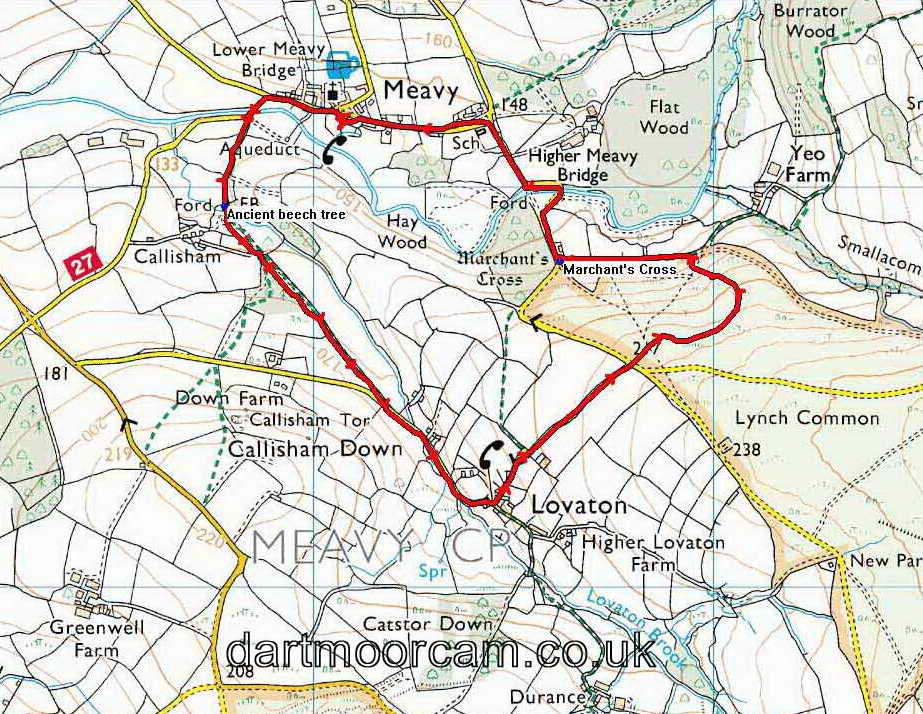
MAP: Red = GPS satellite track of the walk.

© Crown copyright and database rights 2012 Ordnance
Survey
Licence number 100047373
Also, Copyright © 2005, Memory-Map Europe, with permission.
This walk was reached by turning right at Dousland beside the Burrator Inn and following the signs to Meavy: parking is available around the village green, on the road or in the car park behind the village hall.
Statistics
Distance - 3.97 km / 2.47 miles.
All photographs on this web site are copyright ©2007-2016 Keith Ryan.
All rights reserved - please email for permissions
Dartmoor Tick Watch
The Cornish Pasty - The Compleat Pastypaedia
