|
F11 - Full screen F11 - Normal view Home & Contents |
|
"Alt" + � |
This walk: 2014-1-8. Lane End, Wheal Jewell Mine Leat / Reddaford Leat, John Taylor, Nattor Farm, Baggator, sluice, Nat Tor, footbridge, Tavy Cleave, Ger Tor, River Tavy, depth gauge, survey station, head weir.
|
|
This present page gives full screen height photos on pc's with most browsers. It can be a problem on Apple devices - if so, click the Apple-page link.
Walk details below - Information about the route etc.
Link to Google Satellite view of the area incl a GPS track of the walk.
Notice in the Lane End car park. Click the image to see a larger version.
The Wheal Jewell Mine Leat / Reddaford Leat, up the slope from the car park.
The leat contours around the hill (Kingsett Down?) to a tower (marked by the "V") at the modern Wheal Jewell Reservoir - I thought it was further left, hence the empty area of the photograph!
Enlarged portion of the previous photograph.
Along the leat - there will be several similar photographs!
Looking back - the leat was engineered by JohnTaylor in the 1820s and powered 17 water wheels in 1875, one being 51 x 10 feet in size.
Nattor Farm, first recorded in 1340. Occupied by the Reep family for 200 years: in the Napoleonic Wars (1803-1815), William Reep delivered milk to the Princetown prison daily by packhorse!
Baggator, SX 548 806, elevation 372 metres (1220 feet).
A sluice point. The engineering of the leat is such that from the head weir (328 m) to the footbridge (327 m) has a drop of just 1 metre. To the reservoir, three miles away, the drop was six metres.
A piece of worked granite laying beside the leat ...... SX 54500 82298 (close to) .... there appears to have been a bridge here over the leat on Google Satellite view .....
Seen again in this photograph.
Looking up Tavy Cleave, with Nat Tor at left.
Looking up Tavy Cleave, walking along the leat, with the River Tavy down on the right.
River Tavy with Ger Tor above, SX 546 830, elevation 430 metres (1410 feet).
Looking back the way we came from, with a meander in the river.
A device for measuring the level of water in the leat. Could this relay the information to somewhere else ..... this is close to SX 54902 82936, near the head of the leat .....
This presumably is indicating 0.74 metres depth .....
A surveying station alongside the depth gauge.
Another sluice, drain-off point, with the head of the leat in sight .....
Another view .....
This looks like an old monitoring station over the leat - I believe I read somewhere there are only two of these in use on the moor? There used to be one at Beardown?
Interesting structure .....
A valve that operates how, precisely, on the head weir?
Closer view.
Fairly low-level view up the River Tavy.
Old bird's nest in the blockhouse.
The leat is lined in this area.
The rain came in a little before midday, more or less in line with the Met Office warning although it must have started earlier further west in Cornwall?
A warning email from the Met. Office for the day .....
You are subscribed to South West England for
Met Office
Yellow Warning of Rain for South West England
Yellow Warning of Rain for South West England : Cornwall, Devon, Plymouth,
Somerset, Torbay & Gloucestershire valid from 1200 Wed 08 Jan to 0900 Thu 09
Jan
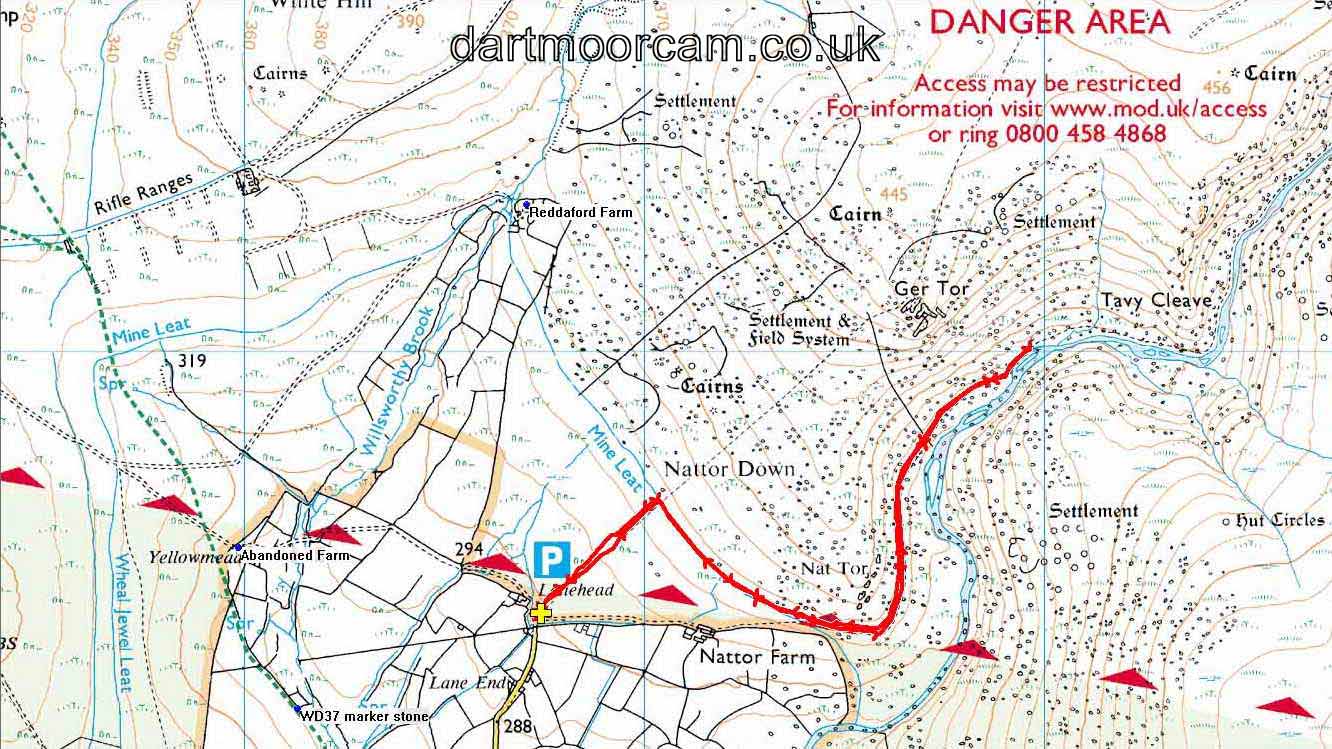
MAP: Red = GPS satellite track of the walk.

© Crown copyright and database rights 2012 Ordnance
Survey
Licence number 100047373
Also, Copyright © 2005, Memory-Map Europe, with permission.
This walk was reached turning off the A386 by the Mary Tavy Inn and following signs to Horndon, Zoar, Willsworthy and Lane End, parking at the P symbol / yellow cross on the map, marked Lanehead on the map.
Statistics
Distance - 4.45 km / 2.77 miles.
All photographs on this web site are copyright ©2007-2016 Keith Ryan.
All rights reserved - please email for permissions
Dartmoor Tick Watch
The Cornish Pasty - The Compleat Pastypaedia
