|
F11 - Full screen F11 - Normal view Home & Contents |
|
"Alt" + � |
|||
This walk: 2013-3-20. Steps Bridge, River Teign, Dunsford Wood, mill leat, coppiced oak, wild daffodils, leaf litter, copper beech, exposed tree roots, branched lichen, unidentified moss, coppiced stool, Dolly's Seat, leat sluice.
Walk details below - Information about the route etc.
Link to Google Satellite view of the area - Steps Bridge, over the River Teign, is at the bottom right corner of the aerial view.
Previous walk at this site - 23 March 2011.
Dunsford Reserve, 140 acres, contains a lot of upland oak and hazel. Rare species include the Wild Service Tree, otters, fly catchers, redstarts, dippers, kingfishers, woodpeckers and five species of fritillary butterfly. The steep-sided bracken slopes are managed for the butterflies.
Steps Bridge, seen from the west, looking towards Dunsford.
Looking down-river .....
Looking up-river: we walked through the woods seen on the right.
Looking down-river. The River Teign consists of .....
-
the North Teign River, rising at Teign Head (near Quintin's Man, just east of the head of the East Dart), passing by Teignhead Farm, Fernworthy, and
-
the South Teign River which rises near the double stone circle of Grey Wethers, flows into Fernworthy Reservoir and out again.
The two rivers join together at Leigh Bridge (SX 683 876) approx. 1 km west of Chagford.
Welcome notice. Click the image to see a larger version.
Notice near the entrance.
Small panorama showing an arch at left for the mill leat and larger arches over the river to the right. Click the image to see a larger version.
A tranquil stretch of river.
General introductory notice. Click the image to see a larger version.
Just a view of the river, its bank and various trees.
Coppiced hazel with catkins, although the notice above states the trees on the valley floor are ash.
A clearing with wild daffodils, Narcissus pseudonarcissus, also known as the Lent Lily,
Daffodils.
A Lent Lily up close .....
Wild daffodil .....
As previous photograph.
The track ahead, the sun shone some of the time.
Leaf litter, predominantly sessile oak, Quercus petraea, also known as the Cornish or Durmast oak, where the leaf margins are not lobed where they join the leaf stalk and the acorns are not stalked but borne directly on the twigs.. The other common oak is Quercus robur, the Common or English oak, whose leaf margins are lobed where they join the leaf stalk and whose acorns are borne on stalks or peduncles .....
Closer view.
A clearing with daffodils .....
Zoomed view.
As previous photograph.
Some autumnal leaves still hanging on.
Exposed tree roots on the river bank, no doubt scoured away by the heavy rains of winter 2012/2013.
A slight 'rapid' in the river.
Unidentified fruticose i.e. branched lichen on a small branch on the ground.
More autumnal leaves, probably copper beech, Fagus sylvatica.
Unidentified moss (possibly a Thuidium species) with apparent reproductive structures which probably belong to an underlying Cladonia lichen that have withered since fruiting .....
As previous photograph - closer view - moss with withered lichen fruiting bodies.
Zoomed view - possibly the podetial/apothecial reproductive structures of a lichen of the Cladonia group?
Another daffodil.
Daffodils.
More exposed tree roots.
As previous photograph.
Yet another clearing with wild daffodils.
A reed or grass clumped around the base of a small tree that is being eroded by the river when it is in spate.
Coppiced stool - hazel or oak?
A river-side bench .....
Dolly's seat.
Daffs across the river - it sounds like a film title .....
Zoomed view.
Back to Steps Bridge.
Sluice to control take-off and flow in the mill leat. "Mills" and the leat are marked on the map, very close to the bridge.
Another sign, near the bridge.
Inscribed stone in the centre(?) of the bridge, under the parapet; "DUNSFORD" ...... on the north-west side .....
"1816" on the opposite side of the road.
Looking up-river from the bridge, at the weir that forms the origin of the mill leat.
A clower view .....
As previous photograph but from a different viewpoint.
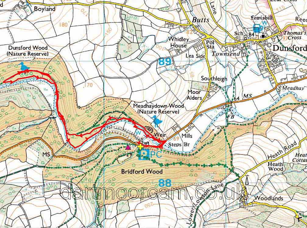
Red = GPS satellite track of the walk.

© Crown copyright and database rights 2012 Ordnance
Survey
Licence number 100047373
Also, Copyright © 2005, Memory-Map Europe, with permission.
This walk was reached from Plymouth via the A38 by turning off after Chudleigh Knighton, this is the Chudleigh turn-off but follow the B3193 Teign Valley road, then the B3212 to Dunsford. Pass the turn-off into Dunsford and follow the road to the bridge. There is parking beyond the bridge with the main area being on the right (SX 803 883), at the the P symbol/yellow cross on the map. There is a small overflow park before this, on the left. There is also some roadside parking just before the bridge, on the right.
Statistics
Distance - 5.27 km / 3.28 miles.
All photographs on this web site are copyright ©2007-2016 Keith Ryan.
All rights reserved - please email for permissions
Dartmoor Tick Watch
The Cornish Pasty - The Compleat Pastypaedia
