|
F11 - Full screen F11 - Normal view Home |
 Previous walks Full Screen Viewing Links Weather |
"Backspace" to go back pages Contents |
This walk: 2012-9-26. Round Pound, Watern Tor, Thirlestone, hut circles, Batworthy, Kes Tor, Scorhill Tor, Little Kes Tor, Castle Drogo, Haytor Rocks, rock pans, Middle Tor, The Longstone, Thornworthy Tor, rainbow, double stone rows, cists, fourfold stone circle, fallen menhir.
Walk details below - Information about the route etc.
Link to Google Satellite view of the area - Round Pound is half on the map. by the road at the top edge; Kes Tor is near-central; Middle Tor is half on ther map towards the bottom-right. Batworthy Corner is the corner of fields left of Kes Tor.
Round Pound enclosure and hut circles at SX 6638 8684, click the image to see a larger version ..... this photo is a distortion (of a montage) because the camera, close-up, gives a fish-eye effect, the road is actually straight when passing the pound! I should have stood further back and used a little 'zoom'.
The pound contains a central hut that was excavated in 1951 and 1952 by Lady Fox who found Iron Age artefacts, as well as a Bronze Age flint arrowhead. The pound is described J. Butler (1991), Dartmoor Atlas of Antiquities II, 36.1 Kes Tor settlement, pages 170-176.
Part of Round Pound enclosure wall .....
Enclosure wall again with a hut circle towards the top-left.
Zoomed view to Watern Tor and the Thirlestone, 3.5 km (2.2 miles ) to the west.
A substantial hut circle on the slope above (and north-west) of Round Pound.
Zoomed view to the settlement at Batworthy.
Zoomed view to Kes Tor, SX 665 862, elevation 445 metres (1460 feet).
Zoomed view over Batworthy to Scorhill Tor, at approx. SX 6603 8706.
Little Kes Tor, approx. SX 6666 8679, near .....
SX 66662 86796 substantial hut circle .....
Another view .....
An apparent recess in the thick wall, or maybe some large stones have disappeared from this point?
Zoomed view to Castle Drogo, 6.6. km (4.1 miles) distant.
Zoomed view to Haytor Rocks, 13.1 km (8.1 miles) distant.
Explanation .....
Someone got the kettle on?
Approaching Kes Tor .....
Rock pans on the top of Kes Tor .....
Half a walking pole deep!
Another eroded rock basin .....
Another view .....
"Centre" - another pan that has half-eroded away .....
Middle Tor, at SX 6689 8584 .....
Another rock pan .....
An impossible job, hand in the way trying to shield the lens against driving rain, trying to be artisitic(?) with Kes Tor in the distance, and with Tess making a close encounter appearance as well! More off-centre would have been more artistic, but then I would have fallen off the tor! The things I do for my art .....
Looking back at Middle Tor.
2. Tom - Is this Kes Tor, with an artistic gorse bush cunningly placed!
Zoomed view to the The Longstone, across a fair old bog - photo taken from here in case we didn't complete the crossing!
Thornworthy Tor, more or less south, at SX 664 851, elevation 424 metres (1391) .....
As previous photo, zoomed view.
Kes Tor, in the sunlight .....
Middle Tor, in the sun.
Gathered at The Longstone .....
The stone bears three land markers, here GP = Gidleigh Parish and DC = Duchy of Cornwall .....
DC - Duchy of Cornwall .....
GP - Gidleigh Parish .....
C = Chagford.
A rainbow in the distance .....
Off we go, let's see if we can get there .....
Gathered under the rainbow.
Walking north from The Longstone, along a double stone row, most of which is hard to see.
Cist at approx SX 65995 85893, associated with the double stone row (there is another cist and double stone row to follow) ......
Here, the double row is more obvious .....
Fourfold stone circle, and fallen menhir at approximately SX 6594 8602 (i.e. no GPS 'fix' was taken) .....
The fallen menhir bears a GP mark. Underneath, we were told that it says "This side down" .....
The second double stone row, leading back towards Batworthy Corner and the cars .....
Looking back at the fallen menhir and fourfold circle.
Cow Bridge cist, SX 66134 86426 .....
Final view of the cist.
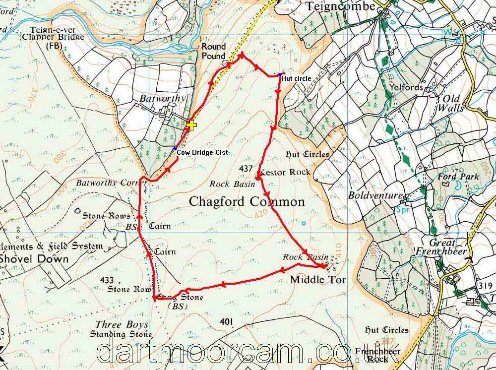
MAP: Red = GPS satellite track of the walk.

© Crown copyright and database rights 2012 Ordnance
Survey
Licence number 100047373
Also, Copyright © 2005, Memory-Map Europe, with permission.
This walk was reached via the following directions - good luck if you try it - the roads are long, twisty and narrow - keep your elbows in!
From Warren House Inn (towards Moretonhampstead) .....
-
Take 1st road on LEFT � route to Fernworthy
-
Pass Jurston Farm
-
Yellands Crossroads � TURN LEFT
-
Pass left turn to Lower Corndon
-
Pass right turn .....
-
Take HAIRPIN LEFT to Fernworthy - use the layby to turn the car!
-
Pass a left turn to Higher Corndon
-
Take RIGHT turn and pass Collihole Farm, Hole Farm and Cullaton to T-junction, turn LEFT toTHORN
-
Pass THORN and go to YEO FARM
-
At Yeo Farm bear RIGHT to TEIGNCOMBE
-
Drive through Teigncombe to the end of the road
-
The end-of-the-road car park is marked with the yellow cross.
Statistics
Distance - 4.29 km / 2.7 miles.
All photographs on this web site are copyright ©2007-2016 Keith Ryan.
All rights reserved - please email for permissions
Dartmoor Tick Watch
The Cornish Pasty - The Compleat Pastypaedia