|
F11 - Full screen F11 - Normal view Home |
 Previous walks Full Screen Viewing Links Weather |
"Backspace" to go back pages Contents |
This walk: 2012-9-20. Merrivale (or Mary Alford's) Newtake, three blowing houses, mould stones, abandoned railway embankment, River Walkham, longhouse, unidentified caterpillar, unidentified red Sphagnum moss, wheel pit, Eddystone lighthouse, Smeaton's Tower, Great Mis Tor, Little Mis Tor, Brentor, Merrivale double stone rows, apple crusher.
Walk details below - Information about the route etc.
Link to Google Satellite view of the area - Great Mis Tor is at centre-top. The car park is on the bottom, 1/4m the way in from the left.
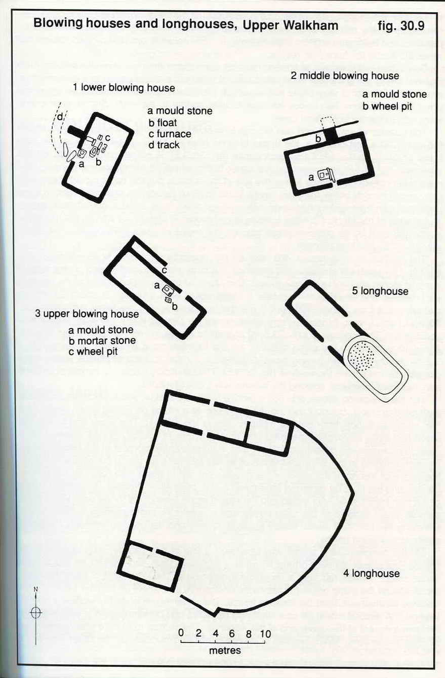
This area is described by Jeremy Butler, 1991, Dartmoor Atlas of Antiquities Vol. 2 - The North, 18-21 Tin working, blowing houses and longhouses along the Walkham (fig. 30.9), pages 78-81. There are three blowing houses described as lower, middle and upper. Also, there are two longhouses of which we saw only one .....

Butler, Dartmoor Atlas of Antiquities Vol. 2, fig. 30.9 reproduced by kind permission of Jeremy Butler (29/9/2012).
Our GPS readings on this walk gave .....
| Location | Grid reference |
| Lower blowing house | SX 55260 75347 |
| Medieval longhouse | SX 55301 76201 - there is a second longhouse somewhere in this area |
| Middle blowing house | SX 55266 76236 |
| Upper blowing house | SX 55194 76636 |
Lower blowing house at SX 55260 75347 ..... 300 metres above Merrivale Bridge in Merrivale (or Mary Alford's) Newtake, described by Jeremy Butler, 1991, Dartmoor Atlas of Antiquities Vol. 2 - The North, 18-21 Tin working, blowing houses and longhouses along the Walkham (fig. 30.9), pages 78-81, as 21 - the lower blowing house .....
Lower blowing house .....
Mould stone at the lower blowing house .....
Lower blowing house feature.
Unidentified caterpillar.
Lower blowing house mould stone.
Abandoned railway embankment to take a railway (Merrivale Light Railway) across the Walkham valley to connect Merrivale quarry with the Princetown railway near King Tor: this was approved in 1908 but the project was abandoned.
Stream running down from Over Tor gert.
Medieval longhouse at SX 55301 76201, view from the uphill end looking down to the River Walkham ..... the structure seems to have two rooms uphill, a cross passageway and a downhill shippon ..... this probably the longhouse depicted as 4 - longhouse in the Butler reference (fig. 30.9) although there is no textual description .....
Medieval longhouse at SX 55301 76201, view from the downhill end looking up towards Great Mis Tor (off upper left).....
A possible drainage hole outside the downhill end ..... or is it a rabbit hole?
Middle blowing house at SX 55266 76236 ..... not a lot to see except for the mould stone ..... described by Butler as 20 - middle blowing house .....
Middle blowing house .....
Middle blowing house ..... with one door jamb still standing (see Butler) .....
Middle blowing house .....
Door jamb at the middle blowing house .....
Mould stone at the middle blowing house .....
Middle blowing house .....
Unidentified red Sphagnum moss .....
Unidentified Sphagnum moss .....
Unidentified Sphagnum moss.
Possible cist at SX 55271 76414, not in the best condition if it is a cist.
We thought this was a bridge from a distance - but we had to wade across the River Walkham!
Upper blowing house at SX 55194 76636, across the River Walkham. A wide, shallow crossing can be found just below the blowing house wall farthest to the right - avoid stepping on larger stones, they might be slippery. Click the photo to see a larger version ..... This house is described by Jeremy Butler, 1991, Dartmoor Atlas of Antiquities Vol. 2 - The North, 30.18-21 Tin working, blowing houses and longhouses along the Walkham (fig. 30.9), pages 78-81, as 19 - the upper blowing house .....
Upper blowing house .....
Mould stone at Upper blowing house .....
Upper blowing house
Upper blowing house mould stone with two sample moulds - the larger saquare one is quite obvious but there is a shallower one below it .....
Upper blowing house wheel pit .....
Upper blowing house, with wheel pit towards the left edge .....
Upper blowing house .....
Upper blowing house .....
Upper blowing house.
Zoomed and cropped view to the Eddystone lighthouse, 14 miles from Plymouth sea front, about 28 miles (38 km) from here. The main lighthouse and the short stump of Smeaton's Tower can be seen to its right.
Great Mis Tor seen from Little Mis Tor .....
Great Mis Tor .....
The main rock pile and military flag staff at Great Mis tor.
Zoomed view to Brentor.
Great Mis Tor (left and centre) and Little Mis Tor (right).
The two double stone rows at Merrivale .....
The southernmost double stone row .....
As previous photograph .....
The northernmost double stone row.
Abandoned running stone for an apple crusher for making cider, the stone would be used upright, with an axle through it for turning by a horse.
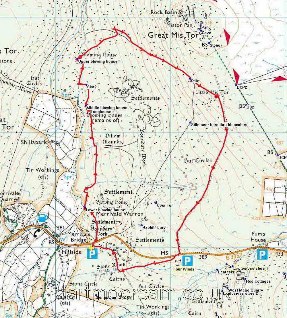
MAP: Red = GPS satellite track of the walk.

© Crown copyright and database rights 2012 Ordnance
Survey
Licence number 100047373
Also, Copyright © 2005, Memory-Map Europe, with permission.
This walk was reached by parking on the B3357 Tavistock-Two Bridges road, just east of Merrivale, at the P symbol with the yellow cross on the map.
Statistics
Distance - 6.56 km / 4.08 miles.
All photographs on this web site are copyright ©2007-2016 Keith Ryan.
All rights reserved - please email for permissions
Dartmoor Tick Watch
The Cornish Pasty - The Compleat Pastypaedia