

Welcome to the Magical Mystery Tour - this topic has exercised me far too long!
Confusion exists around the precise locations of .....
The sources used here are .....
Mike Brown (2001) Guide to Dartmoor, CD-ROM, Dartmoor Press.
Eric Hemery (1983), High Dartmoor, Robert Hale, London, page 118-119.
Paul Rendell (2007), Exploring Around Burrator - A Dartmoor Reservoir, The Dartmoor Company, Okehampton, pages 21, 22 & 55.
The confusion arises partly because one place (Higher Lowery) took the name of another (Lower Lowery) after the former was abandoned. Another reason is that early Ordnance Survey maps show Higher Lowery to the north of Devonport Leat, this being logical after the renaming took place. Then there is the question of Lowery Cottage and East Lowery .....
The first , original Lower Lowery site, information (shortened) on the Heritage Gateway web site .....
| HER Number: | MDV20621 |
|---|---|
| Name: | Deserted farmstead at Lowery, Burrator |
No longer extant; probable medieval farmstead in use until the mid-late 19th century. Effectively destroyed when the road around the reservoir was made. Named as Lower Lowery on the Tithe Map; the farm to the north later took this name, although on the Tithe Map it was then known as Higher Lowery.
| Grid Reference: | SX 555 690 |
|---|
Ordnance Survey, 1880 - 1899, First Edition Ordnance Survey 25 inch map (Cartographic). SDV336179.
One single building shown remaining on the late 19th century historic map. Farmstead not marked and appears to be out of use by this time. Map object based on this source.
Greeves, T. A. P., 1979, South West Water Authority Burrator Survey, No.72 /plans in SMR (Report - non-specific). SDV278356.
Lower Lowery Farm. Deserted site. Farm with several buildings marked on 1840 Tithe Map. No surviving remains. The site was finally destroyed when the road around the reservoir was made. One building still survived in 1906. One building shown on 1887 historic map.
Copyright guidance - Information from the Devon & Dartmoor Historic Environment Record
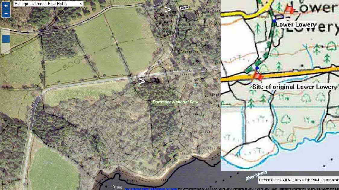
In other words, this original site, believed to date from 1256-1417 was destroyed by the building of the road around the modern reservoir and / or subsequent afforestation.

Reproduced with the permission of the National Library of Scotland
and Memory-Map Europe, with permission.
The image above is a composite old OS map overlying a Bing Map layer, where the present Lower Lowery barn is indicated by the white pointer at the top of the image and the old, original site of Lower Lowery is similarly indicated near the centre of the image. The OS map indicates the old site at Lat / Long -4.0381�, 50.5035�. The inset is a Memory Map image with this Lat / Long converted to a National Grid Reference, SX 55564 69063. This is just inside the fence, about 30 metres from the stile.

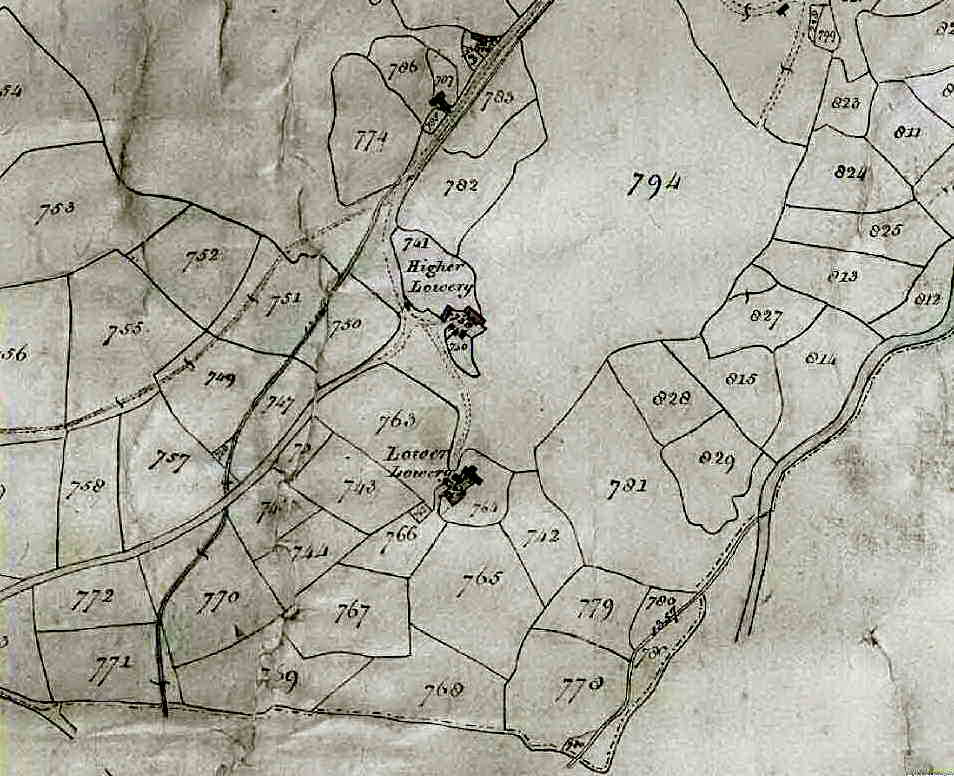
Tithe map
Reproduced from the Ordnance Survey mapping with the permission of the
controller of Her
Majesty's Stationery Office � Crown Copyright.
Unauthorised reproduction infringes Crown copyright and may lead to prosecution
or civil proceedings. Licence no. 100019783
Tithe maps were drawn in the decade following the Tithe Commutation Act, 1836. This replaced the payment of tithes "in kind", a tithe was a tenth of any produce grown etc. payable to the Church monasteries, and after their dissolution they were paid to landlords. Tithes were then paid in cash, for the mostpart. Each map was accompanied by an Apportionment Schedule, this numbered each item and listed whether tithes were to be paid to the owner or the Crown.
The section of tithe map above shows "Higher Lowery", which is today's Lower Lowery. Parcel 707 show a homestead which was later called Higher Lowery on the 1st Edition 1887 25-inch single sheet OS map - this was also known as Lowery Cottage. An unlabelled homestead shown north-east of this that was known as East Lowery. Towards the bottom of the map is the original "Lower Lowery", now lost. Once, one location was known as Middle Lowery - presumably today's Lower Lowery (marked as Higher Lowery on this tithe map)..
This should dispel any confusion!
Lower Lowery (formerly called Higher Lowery and possibly Middle Lowery)
Present-day Lower Lowery, with the restored barn
| HER Number: | MDV20611 |
|---|---|
| Name: | Lower Lowery farm, Burrator |
Deserted medieval farmstead, named as 'Higher Lowery' on the Tithe Map. Deserted farm complex dating to the medieval period. Was occupied into the early 20th century. One barn continued in use as a store in the later 20th century. Appears to have changed its 'Higher' for 'Lower' after the demise of the original Lower Lowery to the south.
| Grid Reference: | SX 556 692 |
|---|
Devon County Council, 1838-1848, Tithe Mosaic, approximately 1838-1848, 34/55 on pdf (Cartographic). SDV349431.
'Higher Lowery' is depicted on the Tithe Map. Plot numbers: 738,740,741 (house, court and garden). Farmhouse lies on the eastern side of the farm, with another building on the northern side of the yard. Collection of three smaller buildings to the west of the yard.
Ordnance Survey, 1880 - 1899, First Edition Ordnance Survey 25 inch map (Cartographic). SDV336179.
The late 19th century historic map shows the farm has expanded to the west, with a further range of buildings added. Marked as 'Lower Lowery' on this map. Map object partly based on this source.
Greeves, T. A. P., 1979, South
West Water Authority Burrator Survey, No.60, plans (in smr) (Report
- non-specific). SDV278356.
Lower Lowery Farm. Deserted farm complex. Recorded on 1840 Tithe Map as Higher Lowery. Complex of farm buildings, all of which are ruined except one barn which is used as a store by the South West Water Authority and is in good condition. The south wall of this barn has two stones "M L" and "1875" in it. Still occupied early in the 20th century. A new dwelling house was built on the west side of the lane between 1840 and 1882-3.
Ordnance Survey, 2015, MasterMap (Cartographic). SDV357601.
Parts of the outline of the farmstead still visible on the modern mapping, along with the remaining building. Map object based on this source.
| MDV20621 | Related to: Deserted farmstead at Lowery, Burrator (Monument) |
| MDV20614 | Related to: Higher Lowery deserted farm, Walkhampton (Monument) |
| MDV12732 | Related to: Leathertor Deserted Medieval Farmstead, Walkhampton (Monument) |
| MDV3441 | Related to: Stone cross at Lowery, Burrator (Monument) |
Copyright guidance - Information from the Devon & Dartmoor Historic Environment Record
Higher Lowery (now disappeared) - built 1807 as the leatman's cottage, also called Lowery Cottage
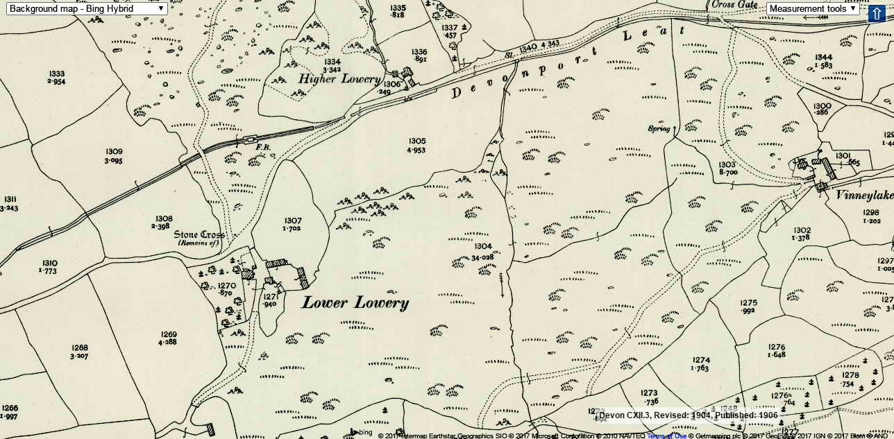
Shown north of the Devonport Leat on old maps - e.g. OS 6-inch 1886 - single sheet map, showing the area before the reservoir was built. Surveyed 1886.

Reproduced with the permission of the National Library of Scotland
Ordnance Survey 1890s-1920s 25-inch map

Higher Lowery Devonport
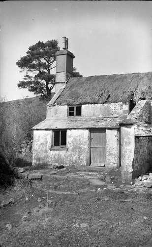
Leatman's House,
Built 1807, by the Dock Water Company, occupied until 1922, 115 yrs.
Devonport Leat was contracted 1793 and completed 1801
Dock became renamed Devonport in 1824
Photograph used by kind permission of The Dartmoor Trust Archive
| HER Number: | MDV20614 |
|---|---|
| Name: | Higher Lowery deserted farm, Walkhampton |
No longer extant. Farmstead dating to at least the early-mid 19th century, based on cartographic evidence, although may have had earlier origins. Not originally called Higher Lowery; see Tithe Map. Dwelling and additional farm buildings depicted on the historic maps but the farm appears to have declined and only the house remained, occupied until around 1922.
| Grid Reference: | SX 557 694 |
|---|
Devon County Council, 1838-1848, Tithe Mosaic, approximately 1838-1848, 36/55 on pdf (Cartographic). SDV349431.
Homestead is depicted on the Tithe Map and comprises just a single building with associated land plots. 784 on the Walkhampton apportionment; 'Tenement near Lowery' (house and court).
Ordnance Survey, 1880 - 1899, First Edition Ordnance Survey 25 inch map (Cartographic). SDV336179.
Higher Lowery is depicted on the late 19th century historic map. By this time, the farmhouse appears to have been altered (perhaps extended) and there are at least two new buildings depicted at the farm.
Ordnance Survey, 1904 - 1906, Second Edition Ordnance Survey 25 inch Map (Cartographic). SDV325644.
The early 20th century historic map shows the farm is largely unchanged from the late 19th century historic map depiction. Map object based on this source.
Haynes, R. G., 1966-1969, Ruined Sites on Dartmoor, 74 (Un-published). SDV150434.
Higher Lowery. Deserted farm. Otherwise known as Lowery Cottage. Marked as "tenement near Lowery" on 1840 Tithe Map. Now a complex of ruined buildings.
Greeves, T. A. P., 1979, South West Water Authority Burrator Survey, no. 63 (Report - non-specific). SDV278356.
Occupied until around 1922 by an employee of the Plymouth Corporation. The cottage seems to have been destroyed intentionally and only the lavatory remains intact. Water came from a higher level via an iron pipe to a granite trough. The building was of mortared stone.
Sherd found at Higher Lowery (undated).
Sherd of 17th/18th century gravel-tempered ware from site of Higher
Lowery.
Rim sherd, body sherd and abraded fragment of pot of 16th/17th century
from debris of wall at site of Higher Lowery.
Stoneware sherd (17th/early 18th century) from Higher Lowery.
(N.B. Although these are all described as being from Higher Lowery,
these finds were originally located at the site of
East Lowery;
roughly SX558 694) A F Richards.
03/06/1977: Sherds of glazed xviii and xix century pottery have been
found at this site (N. B. Assumed to mean Higher Lowery as the grid
reference matches the site) A F Richards.
Copyright guidance - Information from the Devon & Dartmoor Historic Environment Record
Addendum 1 - If THIS OLD MAP is examined (OS 25-inch 1890s-1920s) and and the blue round slider is moved to the LEFT, to show the underlying Google Satellite view, it will be seen that the modern road appears just north of the building on the old map - this was probably the original Lower Lowery.
Addendum 2 - From Mike Brown (2001) Guide to Dartmoor, CD-ROM, Dartmoor Press, ref. 55756942.
Some large rocks and the paltry remains of some foundations overlooking the little streamlet which flows along the west side of the large patch of greensward are all that remain of Lowery Cottage, built in 1807 by the Plymouth Dock Water Company � Dock is the old name for Devonport. The property entry is written thus on the first page which was newly opened under the company heading (named as the lessees) in the Maristow estate rental ledger of 1808 �
29th Sept 1808 Rent of a Cottage and a Plot of ground lately built and
Inclosed from Lowery Steant, granted to them for 30 years from
Michaelmas 1807
The name of Dock was changed to Devonport in 1824.
| HER Number: | MDV20615 |
|---|---|
| Name: | East Lowery Farm deserted settlement |
No longer extant. Farmstead dating to at least the early-mid 19th century, based on cartographic evidence, although may have had earlier origins. Dwelling is depicted on the Tithe Map but not shown on the later 19th century historic map.
| Grid Reference: | SX 558 694 |
|---|
Devon County Council, 1838-1848, Tithe Mosaic, approximately 1838-1848, 36/55 on pdf (Cartographic). SDV349431.
'East Lowery' is depicted on Tithe Map (plot number 788 on the apportionment; houses and court). Farm consists of a singled building in a subdivided triangular shaped plot. Map object based on this source.
Ordnance Survey, 1880 - 1899, First Edition Ordnance Survey 25 inch map (Cartographic). SDV336179.
No sign of the building on the late 19th century historic map; the triangular shaped plot that the house occupied is depicted.
Greeves, T. A. P., 1979, South West Water Authority Burrator Survey, Number 64 (Report - non-specific). SDV278356.
East Lowery Farm. Deserted site. Complex of ruined buildings some probably medieval in origin. East Loworthy is documented in 1585. The area has recently been damaged by tree felling and sherds of 16th, 17th and 18th century pottery of both local and imported wares have been recovered. Not marked on Ordnance Survey 25 inch map.
| MDV20614 | Related to: Higher Lowery deserted farm, Walkhampton (Monument_ |
Copyright guidance -
Information from the
Devon & Dartmoor Historic Environment Record
Other local uses of the name "Lowery" .....
Lowery Tank - a small enclosure, described as originally containing a tank-like feature of unknown purpose in Devonport Leat No longer apparent.
Lowery Stent - the "stroll" (a passage between walls / enclosures often allowing access to common land, extending here from the nearby road up towards Peek Hill
Lowery Tor - overlooking the Lowery area, en route to Peek Hill, SX 5563 6976, elevation 367 metres (1204 feet)
Lowery Quarry - abandoned, SX 5555 6960, on the south flank of Peek Hill
Lowery Moor - the area east of the Lowery settlements, now afforested
Lowery Cross 1 - a local name for Cross Gate Cross, also known as Leather Cross
Old maps also show "Stone Cross - Remains of" just north-west of Lower Lowry, possibly an original, stone Lowery Cross proper
Lowery Cross 2 - local road junction, not a cross-roads.
Middle Lowery is mentioned by Rendell (p.21), this may have been today's Lower Lowery, between the original Lower Lowery (lost when the reservoir ring road was built) and Higher Lowery (that was north of the leat)
Lowery Road - shown on old maps as running from Lowery Cross to Cross Gate
Lowery Lane - I thought I saw this somewhere as the lane down to the
original Lower Lowery, but I can't find it again.
"Lowerthylane"
- eventually found in (Mike Brown (2001) Guide to Dartmoor,
CD-ROM, Dartmoor Press,
grid reference 5575 6942 .
From the context, this might refer to the later-named Lowery Road.
Key to old OS map abbreviations .....
B.M = Bench Mark
G.P = Guide Post i.e. signpost
L.B = Letter Box (or London Borough!)
S.B - Signal Box
By about 1870, East and Lower Lowery were knocked down and replaced by a larger farmhouse (extrapolated from Rendell, p.22). Perhaps this was today's Lower Lowery, with its present day barn? The datestone on the barn is 1873.
All photographs on this web site are copyright © Keith Ryan.
All rights reserved - please email for permissions