![]()


This walk: 2016-6-30. Round or Roundy Hill, millstone, Roundypark Farm.
Walk details below - Information about the route etc.
Where we walked: Google Satellite view of the area - including the GPS track of the walk (compare with the Ordnance Survey map plus track below)
Previous walk in this area: 16th October 2012, 26th April 2013 and 23rd June 2016.
In 1980, I did a map-and-compass navigation course with a member of Dartmoor Rescue through the WEA (Workers' Education Association, Plymouth). One of the walks went past Crazywell Pool and, nearby, we were shown an abandoned millstone. After a long break, I started walking again in 2007 and bought a small book, "Walking in Southern Dartmoor", published by Dartmoor Rescue Group; Plymouth Section. In Walk 11, "Mines, Farms, Water and Forest", it notes on page 55 that, after leaving Crazywell Pool and after reaching the Norsworthy-Nunn's Cross track, "Just over 100 metres before reaching the edge of the forest and 40 metres up to the right is is a stone shaped as a millstone". I have passed this way many times since 2007 but never found it again, including on 23rd June 2016. Today, I was prepared with marker flags and loppers, for the gorse. I started a four-box search but the GPS unit was not used to record it because the recorded track would have looked too "busy".
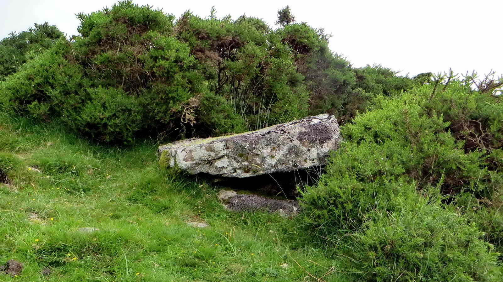
 The abandoned millstone, at SX 57960 70125, with imperfections .....
 More of a "face" view.
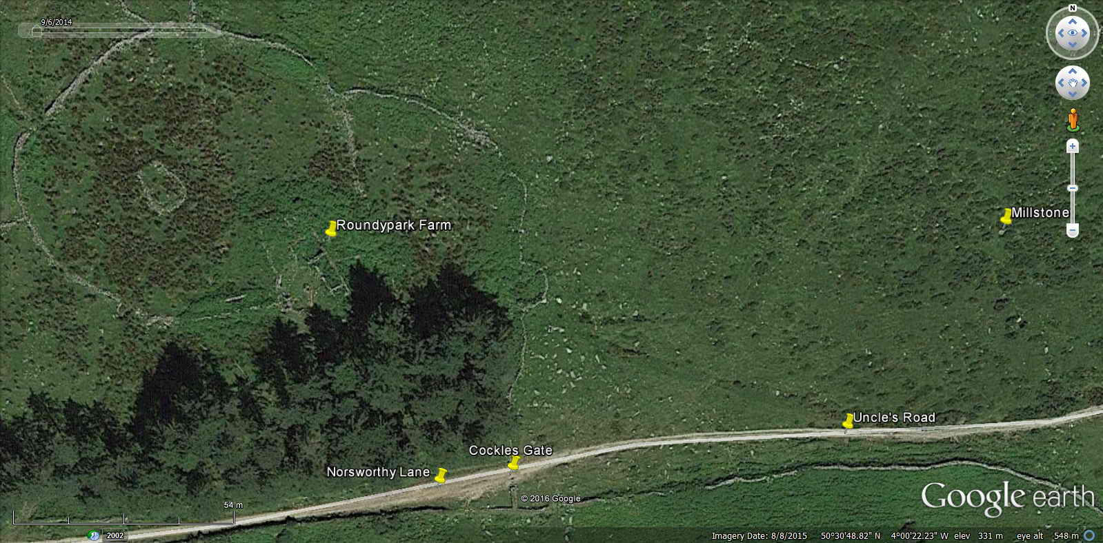
 This old gorse bush is beside the
track, 112 metres from Cockle's Gate; the millstone is visible from the track
and is marked by the "V" - 46 metres from the track.
This old gorse bush is beside the
track, 112 metres from Cockle's Gate; the millstone is visible from the track
and is marked by the "V" - 46 metres from the track.
 Zoomed view from the track.
 Another view, a few paces further
towards Nunn's Cross, with the track seen at the bottom of the photograph: the
section of track from Cockle's Gate to Whiteworks and Peat Cott is known as
Uncle's Road (Mike Brown's CD-ROM, 57837006).
Another view, a few paces further
towards Nunn's Cross, with the track seen at the bottom of the photograph: the
section of track from Cockle's Gate to Whiteworks and Peat Cott is known as
Uncle's Road (Mike Brown's CD-ROM, 57837006).
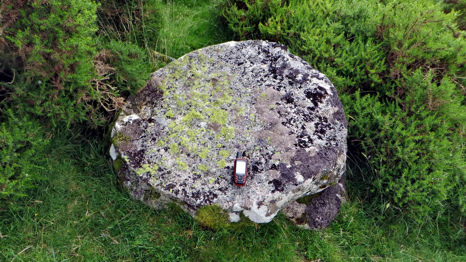 Using a GPS unit to show scale: the
left-right dimension is about 820 cm.
Using a GPS unit to show scale: the
left-right dimension is about 820 cm.
 Another view, showing the gorse that
almost surrounds it .....
Another view, showing the gorse that
almost surrounds it .....
 Closer view.
 The millstone can be seen by aerial
photography .....
The millstone can be seen by aerial
photography .....
 Zoomed aerial view, note the gorse
bushes at "12 o'clock" and "4 o'clock".
Zoomed aerial view, note the gorse
bushes at "12 o'clock" and "4 o'clock".
 A way in to into Roundypark Farm.
The millstone is behind the camera, on a bearing of 82�, at a distance of 113
metres.
A way in to into Roundypark Farm.
The millstone is behind the camera, on a bearing of 82�, at a distance of 113
metres.
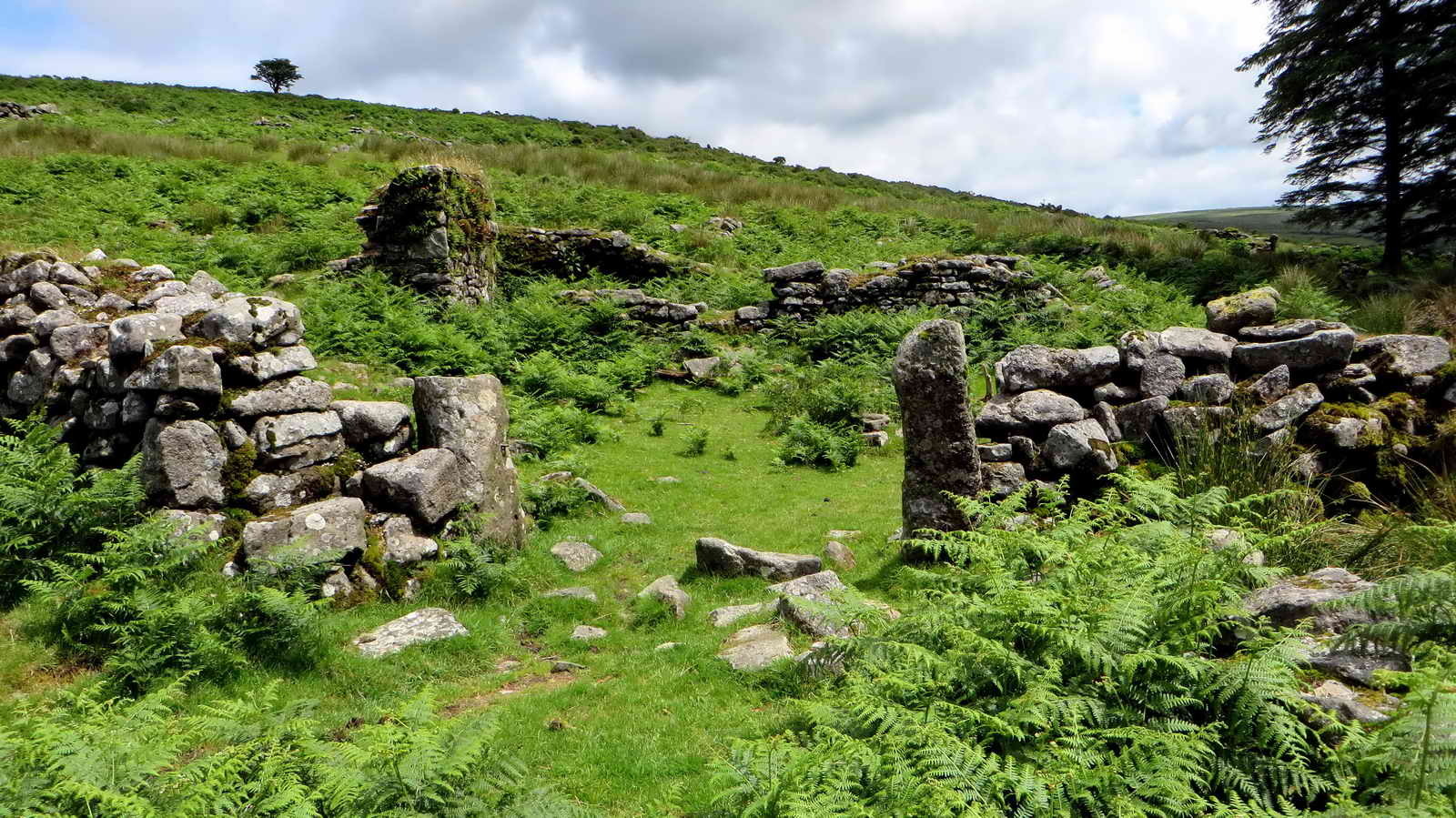 A general view of the ruins of
Roundypark Farm. The original door arch from the farm forms the higher archway
across The Lawn of The Lodge at Burrator Reservoir, in Wembley Walk. It is
inscribed "RC 1668" and was installed there in 1934 (Hemery, page 115). Crossing
maintained that RC was Richard Crymes of Crapstone, but Hemery supports Mr. L
Govier of Whitchurch, in that the initials refer to a member of the Cockell /
Cockle family who once farmed at Roundypark and Kingsett farms (Source: Mike
Brown CD-ROM)
A general view of the ruins of
Roundypark Farm. The original door arch from the farm forms the higher archway
across The Lawn of The Lodge at Burrator Reservoir, in Wembley Walk. It is
inscribed "RC 1668" and was installed there in 1934 (Hemery, page 115). Crossing
maintained that RC was Richard Crymes of Crapstone, but Hemery supports Mr. L
Govier of Whitchurch, in that the initials refer to a member of the Cockell /
Cockle family who once farmed at Roundypark and Kingsett farms (Source: Mike
Brown CD-ROM).
Further reading Eric Hemery (1983), High Dartmoor Robert Hale, London, pages 140-143 and Figure 86. Mike Brown's Guide to Dartmoor CD-ROM (2001), Dartmoor Press, Plymouth - see the large section under "57807011".
MAP: Red = GPS satellite track of the walk.
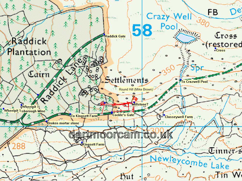
© Crown copyright and database rights 2015. Ordnance Survey
Licence number 100047373
Use of this data is subject to terms and conditions.
Also, Copyright © 2005, Memory-Map Europe, with permission.
This walk was reached by driving from Dousland (Yelverton) towards Meavy and turning left to Burrator Reservoir. The car park is over Norsworthy Bridge at the north end of the reservoir.
All photographs on this web site are copyright ©2007-2016 Keith Ryan.
All rights reserved - please email for permissions