

This walk: 2016-10-13: Fernworthy Reservoir, Fernworthy Dam, Fernworthy Farm, Fernworthy Bridge, cist, clapper bridge, rhos pasture, rowan, Froggymead Hill stone circle and stone rows, Thornworthy Tor.
Walk details below - Information about the route etc.
Previous walk/s in this area: 3rd June 2015 and 23rd March 2016.
Link to Google Satellite view of the area including the GPS track of the walk (compare with the Ordnance Survey map plus track below)
Background
Phil Newman (2013). The Archaeology of Fernworthy Forest, Dartmoor, Devon. states: Forestry commenced at Fernworthy shortly after the land was acquired by the Duchy of Cornwall estate in 1917 and by 1930 the conifers covered more than 800 acres (324ha)(Gill 1970, 269).
Mike Brown (2001) CD-ROM "Guide to Dartmoor", Square 6584: "The Fernworthy area was the first large tract of conifer plantations on Dartmoor, comprising mainly Sitka Spruce, planted after World War One when there was a shortage of softwood timber, unlike today when we have such a glut that the only thing the trees can be used for is chipboard. The plantations here cover some 1500 acres, which is around 1499� acres more than is presently necessary."
Bronze Age hut circles at SX 6708 8422 on the shore of Ferrnworthy Reservoir, near the dam, part of Metherall settlement. Source: Jeremy Butler (1991), Dartmoor Atlas of Antiquities, Vol. 2 - The North, 1: Metherall settlement (fig.35.1), pages 155-156. There are eight spacious circles in this area.
Approaching Fernworthy Dam from the car park.
Rowan aka Mountain Ash, Sorbus aucuparia .....
Rowan berries, plentiful, the sign of a bounteous summer or a hard winter to follow?
The dam - the reservoir was opened in 1942 and is fed by the South Teign River, Assycombe Brook, Lowton Brook and others. Sources: Dartmoor Reservoirs (Wikipedia) and Eric Hemery (1983), High Dartmoor, Robert Hale, London, page 753.
Closer view.
Looking along the dam from the south end - no way through!
Sign fixed to the wall opposite the south end of the dam.
Scene below the dam .....
Some detail .....
Notice the various slightly protruding blocks .....
The miniscule spillage in progress during this dry period. .....
As previous photograph.
View from the footbridge over the South Teign River, looking towards the dam.
The footbridge.
Looking south along the dam ..... note the drainage sppouts .....
The foreshore next to the dam. Eric Hemery (1983), High Dartmoor, Robert Hale, London, page 753, records .....
"The reservoir covers seventy-six acres of land, impounds 380 million gallons, is sixty-three feet deep, fourteen hundred yards long and 1,125 yards wide; the dam 685 feet long, necessitated an excavation eighty-five feet deep and thirty-five feet wide. No dwellings or farm buildings were submerged but certain smaller objects, including some prehistoric retaining-circles, lie below normal water level".
A pair of Mallard ducks.
The Boathouse, seen across the reservoir, very close to the hut circles seen above.
A pair of evocative gateposts protruding from the lake .....
Zoomed view .....
Ditto .....
Remains of field walls from the abandoned Fernworthy Farm.
A brok without a name on the modern map, lookinmg towards the gate posts.
Just a few metres "inland" from the shore, up the stream, a modern boundary stone between Dartmoor Forest and ......
Chagford civil parishes, dated MM - 2,000.
"Kistvaen" - A stone coffin, from from the Celtic cist, a chest, and maen, stone, v being used as a mutation of m. (Source: Crossing's Guide to Dartmoor, 2nd edition 1912, reprinted 1990, page 22). This is Thornworthy cist, at SX 66744 84339, about 10 metres from the edge of the reservoir. There were originally two here when first found in 1878, covered by a cairn with a smaller cist within the cairn, to the south east. The central cist was excavated but the smaller one was left to be attended to later but was ransacked before it was excavated. This cist was later removed to Torbay Museum, although it is now on display in the Dartmoor Conservation Garden at Princetown. Source: Jeremy Butler (1991), Dartmoor Atlas of Antiquities, Vol. 2 - The North, 22: Thornworthy cairn and cists (no figure) page 169.
Another view.
There is a length of boardwalk along the way.
Rhos pasture at Fernworthy farm - Dartmoor National Park link about rhos pasture .....
"The most distinctive plants of this habitat on Dartmoor are the meadow thistle, devil�s-bit scabious, heath spotted orchid and saw-wort, all colourful plants. They grow in amongst either purple moor-grass or sharp-flowered rush and there may be some creeping willow present. Other plants that can be found include ivy-leaved bellflower, lesser spearwort, marsh thistle, sneezewort, greater bird�s foot trefoil and marsh violet (see Dartmoor Pocket Guide � Bog Plants).
Rh�s pasture is home to marbled white butterflies, which can be abundant, small pearl-bordered fritillary and the highly protected marsh fritillary which is found in colonies representing about 20% of the English resource. One of Britain�s rarest damselflies, the southern damselfly, also occurs in a single Rh�s pasture on Dartmoor. The rare narrow-bordered bee hawkmoth, which feeds on devil�s bit scabious can also be found, often in association with marsh fritillary."
Zoomed view .....
Click the images to see a larger version.
The only recognisable building remaining at Fernworthy, what looks to a large, open-fronted building, a cart shed? Eric Hemery (1983), High Dartmoor, Robert Hale, London, page 753, states .....
"The ancient farm of Fernworthy ........... was demolished after a documented history of at least 735 years, and, as a 'worthy' , it must have had a Saxon origin, which would take it back a thousand years".
Another view: there are a few other signs, mainly a large flat floor area with hints of a wall.
Looking up the old road towards Teignworthy.
Asplenium, maindenhair fern.
From near the farm ruins, looking out at Fernworthy Dam (far left), Fernworthy bridge (exposed by the low water level) and a clapper bridge .....
Fernworthy Bridge and clapper bridge ..... William Crossing mentions these bridges in Crossing's Guide to Dartmoor:
Making our way down to the Teign [from the kist, q.v. sq 6684] we shall turn R and follow that stream upward to Fernworthy Bridge. Here close to the modern erection is a fine example of the single stone clapper. The slab forming this solid footway is rather over ten feet in length, and nearly four feet wide, and is about a foot thick. The road, which comes down to the bridge from Metheral, runs past the farmhouse to Froggymead Hill, when a green track goes out to Teign Head. (Crossing, p.243)The bridge has been exposed several times in the past, notably in 1955, 1976 and 1995. Sources: The Herald newspaper and pers.comm.
Clapper bridge .....
Fernworthy Bridge .....
Fernworthy Bridge .....
Fernworthy Bridge .....
Fernworthy Bridge .....
Fernworthy Bridge .....
Fernworthy Bridge .....
The dam, viewed from the bridge .....
Fernworthy Bridge .....
Fernworthy Bridge .....

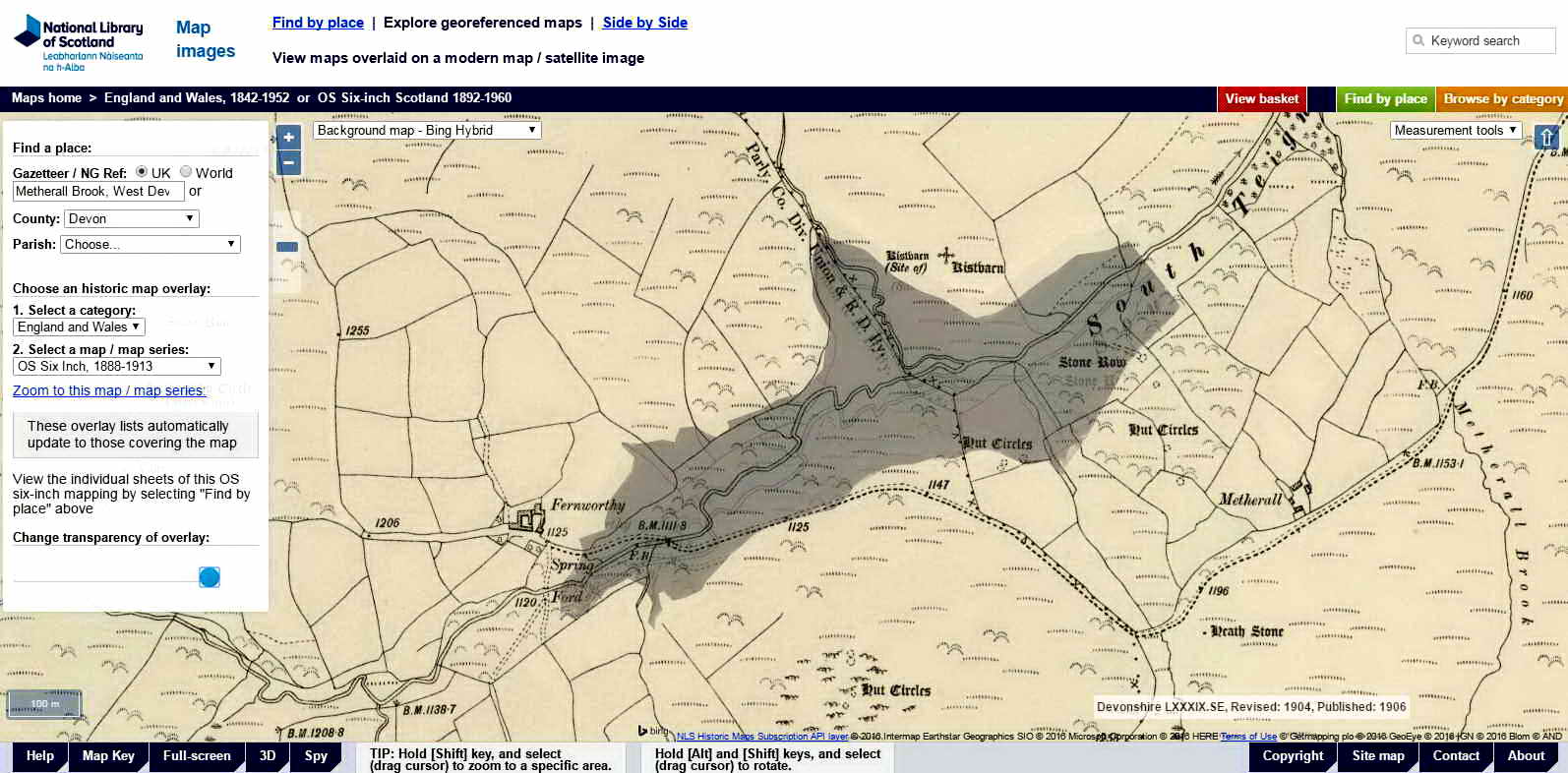
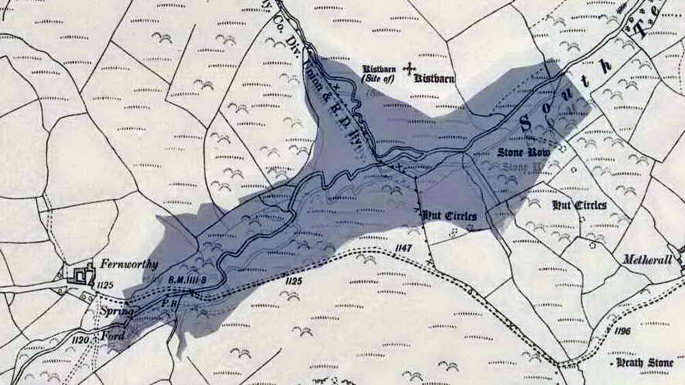
This map is from the OS 1883-1913 Series - LINK: "'Reproduced with the permission of the National Library of Scotland', from: Map images website. The modern reservoir has been superimposed at the same scale to aid understanding ..... .....

An enlarged version of the old map with the reservoir superimposed. The submerged bridge is located below the "BM 111.8" label - presumably the bench mark is somewhere on the bridge. This is where the old road from Metherall to Fernworthy and beyond, to Teignhead Farm, crosses the South Teign River. The "FB" label signifies the presumably much older clapper bridge.
Water to the left of him, water to the right of him!
Ancient tree stump, normally submerged .....
Ancient tree stumps, normally submerged ..... with the bridges behind .....
Ancient tree stumps, normally submerged ..... with the exposed bridges behind.
The circle as depicted in fig. 35.1 below, rows and cairns at Froggymead in Fernworthy Forest. According to Butler, the circle dates from perhaps 4,000 years ago ..... there are 27 stones in the circle which is about 20 metres in diameter ..... there are altogether 5 cairns and three stone rows ..... one cairn and a double stone row are 140 metres to the north-ish. The site is described in J. Butler (1991), Dartmoor Atlas of Antiquities II, The North. 35.15 Fernworthy stone circle, rows and cairns (figs. 35.7 & 35.8), pages 162-165.
The double stone row depicted in fig. 35.8 below .....
The blocking stone .....

Image � J Butler 1991. Reproduced by kind permission (ref. 29 Sept. 2012).
Fly agaric (mature and opened), Amanita muscaria .....
Recently-opened fly agaric toadstool.
Looking along the easily-missable Birch Tor and Vitifer Mine Leat at SX 65588 82843, long disused and overgrown.
Fernworthy Bridge .....
Fernworthy Bridge .....with the dam at the far right .....
Fernworthy Bridge .....
Fernworthy Bridge .....
Fernworthy Bridge .....
Another view of the dam from the south shore of the lake, in afternoon sunshine .....
|
Dartmoor CAM movie. TIPS .....
A panning movie at Fernworthy Reservoir showing the bridge and clapper both exposed during a period of low water levels, in October 2016. |
Click the photo to download> |
Another look at the hut cicrcles seen at the start of the walk .....
As previous photograph ......
Ditto, with Thornworthy Tor behind; SX 66435 85146, elevation 424 metres (1391 feet).
MAP: Red = GPS satellite track of the walk.

Crown copyright and database rights 2016 Ordnance
Survey
Licence number 100047373
Also, Copyright � 2005, Memory-Map Europe, with permission.
This walk was reached by turning LEFT off the B3213 after passing the Warren
House Inn when driving from Two Bridges towarrds Moretonhampstead, through
Jurston, LEFT at the crossroads, first LEFT to Lower and Higher Corndon -
turning RIGHT at Higher Corndon and LEFT at the T-junction, on into the
forest. The car park / toilets are on the RIGHT as you enter the forest,
indicated by the
P
symbol and yellow cross on the map. There is a free car
park at the far end of the road around the reservoir, indicated on the map
above.
This route was based closely on http://www.gps-routes.co.uk/routes/home.nsf/RoutesLinksWalks/fernworthy-reservoir-walking-route#
http://www.gps-routes.co.uk/routes/home.nsf/All/19F70F3E8E86893B85257EA70035E95F/$FILE/Fernworthy%20Reservoir.mmo - Memory Map file
Statistics
Distance - 11.3 km / 7.02 miles
All photographs on this web site are copyright © 2007-2016 Keith Ryan.
All rights reserved - please email for permissions