

This walk: 2015-9-9. Plaster / Plaister Down, Sampford Spiney parish boundary stones, Devil's coach horse, Sharpitor, North Hessary Tor, Sampford Tor, Heckwood Quarry, Vixen Tor, Saddle Rock, Cloven Saddle Rock, Windy Post, Pew Tor.
Walk details below - Information about the route etc.Old maps .....
Overview of old maps
Ordnance Survey, Six-inch to the mile, 1st edition - 1888-1913
Sampford Spiney boundary stone, at SX 52418 72909 .....
Overview.
World War II bomb crater.
Devil's coach horse beetle .....
Devil's coach horse (different link).
In the distance, Sharpitor (left) and Peek Hill (right), seen over Downfield Cottages .....
Zoomed view to Sharpitor.
North Hessary Tor tv transmitter station.
Pewtor Cottage (other names for Pew Tor are Pu Tor and Putor).
Sampford Tor, aka Little Pu Tor, SX 5322 7314,elevation 293 metres (961 feet) .....
Zoomed view.
A large surface stone that has been partially cut into pieces .....
Is this marked by the feather and tare method or by the wedge and groove method?
Another view of the cut cleft.
On the track just prior to Heckwood Quarry .....
Zoomed view.
Dressed stone in Heckwood Quarry .... said to have been destined for Plymouth Breakwater .....
I have seen better sunbeds!

Google Earth image of the granite blocks along the seaward side of Plymouth Breakwater!
Edit - I have been corrected regarding these blocks: sometime in the mid/late-1960s, students were employed, presumably by the Ministry of Public Building and Works, to clean the huge metal moulds that these massive concrete sea defence blocks were made in.
Ponderers.
Vixen Tor, SX 542 742,elevation 317 meters (1040 feet) .....
Slightly zoomed view.
Notice on a gate.
SS P (Sampford Spiney Parish) bound stone at SX 54036 73978 .....
See the "W" signifying Whitchurch on the other side?
Crossing the Amazon?
Another stream to cross.
WB - Whitchurch Boundary .....
Closer view .....
SB - Sampford Boundary, this stone is in the wall at SX 54133 74363 - not far from Saddle Rock .....
Saddle Rock, at SX 54085 74409, on Whitchurch Common .....
"SB" incised into the west face of the stone .....
Second attempt at the group photo - you have to click on the photo to see the naughty first photograph!
Windy Post, on the skyline.
Cloven Saddle Rock, at SX 54004 74804 .....
"SB" on the western face.
Yellow, mauve and green.
Double parish boundary stones, the old one (left) was broken and replaced with the one on the right, at SX 53760 74734.
Windy Post aka
Beckamoor Cross ..... beside the Grimstone and Sortridge Leat .....
Another view .....
As previous photograph .....
And again.
Bullseye stone that governs the takeoff of water into a side leat going towards Oakley Farm etc.
Onwards to Pew Tor.
One of the 1847 mason's marks around Pew Tor beyond which it was forbidden to take stone: more information in the 28th December 2011 walk.
The erection of a marquee on the golf course
ull details of the Sampford Spiney parish boundary stones can be found in Dave Brewer (2002), Dartmoor Boundary Markers, Halsgrove, pages 166-173.
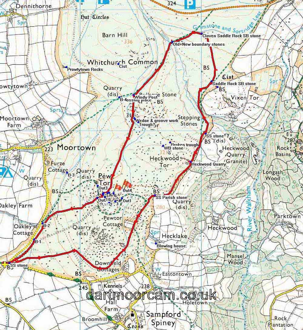
MAP: Red = GPS satellite track of the walk.

This walk was reached by driving from Whitchurch, out past the Whitchurch Inn, across the golf course, follow signs to Princetown, then Moortown, parking on the grass just after turning left for Moortown - marked by thre yellow cross on the map (at SX 52377 72896).
Statistics
Distance - 6.62 km / 4.11 miles.
All photographs on this web site are copyright © 2007-2016 Keith Ryan.
All rights reserved - please email for permissions