

This walk: 2015-4-1. "Walk of a thousand stiles", Mary Tavy Inn, Victorian letter box, St. Mary's Church, William Crossing's grave, step stile, miners' dry, Smeardon Down, Bennett's Reservoir, Gibbet Hill, Jubilee Walk.
Walk details below - Information about the route etc. Old maps .....
VR - Victoria Regina, an old letter box, prior to 1901 when Queen Victoria died, so at least 114 years old and still in daily use.
Seen along the way.
Another scene along the way.
Mary Tavy Village Cross, enclosed into the churchyard when it was extended in 1880 ..... the shaft is not original and is made from Roborough stone .....
St Mary's; Mary Tavy Parish Church, also known as Tavy St. Mary, located in old Mary Tavy ..... note the inscribed stone seen at top left of the dark-coloured headstone (see 2nd photo below) .....
Sun dial over the entrance ..... this was taken a little after 10 am, it shows a little before 9 am ..... perhaps sundials never did British Summer Time!
Inscribed stone: MDCCCXCIII (you may need the Compacta BT font on your computer to see this properly, and then it still isn't great), otherwise - MDCCCXCIII - 1893 - when the south transept was built (see bottom of page 6; thanks to Derek, Minions). My guess was "mortium" (Latin: death) overlooking the graves .....
|
MDCCCXCIII
- MDCCCXCIII
-1893 - when the south transept
was built. |
General view of the church ..... referred to in 1270 in the time of Edward the Confessor, rebuilt in the 1400's in the Norman i.e. perpendicular style, south transept built in 1893.....
Similar view taken on the day when the sun shone briefly .....
The grave of William Crossing (died 1928) and his wife Emma (died 1921), author of the iconic Crossing's Guide to Dartmoor.
Closer view.
National Park signpost for the footpath in the churchyard.
A poignant memorial .....
Closer view.
Step stile in the top left corner of the churchyard.
Almost a caption competition!
Partitioned footpath along the side of one of the fields.
Grade II listed 19th century miners' "dry" of Wheal Friendship Mine, where wet clothes from working underground in the nearby Bennett's Shaft would be dried before the next shift of work ..... approx. SX 5119 7909 ...... more search results .....
The chimney on the miners' dry .....
Chimney top with Common polypody, Polypodium vulgare .....
Looking back.
Stile, at SX 5126 7908, near the dry with a view ..... a set of steps that lead up to a reservoir .....
Bennett's Reservoir, this is supplied by the old Wheal Friendship Mine Leat: it takes its name from a nearby mine shaft and also the name of the ore-bearing lode (Source: Mike Brown's Guide to Dartmoor 2001 CD-ROM).
Last view.
View to Smeardon Down, with Smeardon Rocks on the skyline towards the right.
A later view of the other end of the reservoir, which is approximately 930 metres in length, albeit rather narrow for much of its length .....
Zoomed view.
A barn in the corner of a field.
Could be any road, anywhere, but turn right up ahead .....
We head for Axna.
View to a mine shaft on Gibbet Hill ......
Fenced-off mine shaft with a spoil heap.
Trees with ivy.
Axna Farm.
What breed of cow?
The walkers, on April 1st, bewildered, nearing the end of the "Walk of a Thousand Stiles"!
Another of the nine(?) step stiles on this walk.
Junille Walk, commemorating Queen Elizabeth's Diamond Jubilee, the 60th anniversary of her accession to the throne ..... with Mary Tavy Inn in the distance .....
Attached sign .....
As previous photograph ..... Buller's Hill must be where the public house is marked as "Bullers Arms" on the old map (linked at the top of this web page).
Seat along the path .....
Another sign .....
Approaching the garden at the rear of the Mary Tavy Inn - the walk finished at the gate seen at the left, back onto the hill beside the pub.
The sign at the end of Jubilee Walk, looking back where we came from.
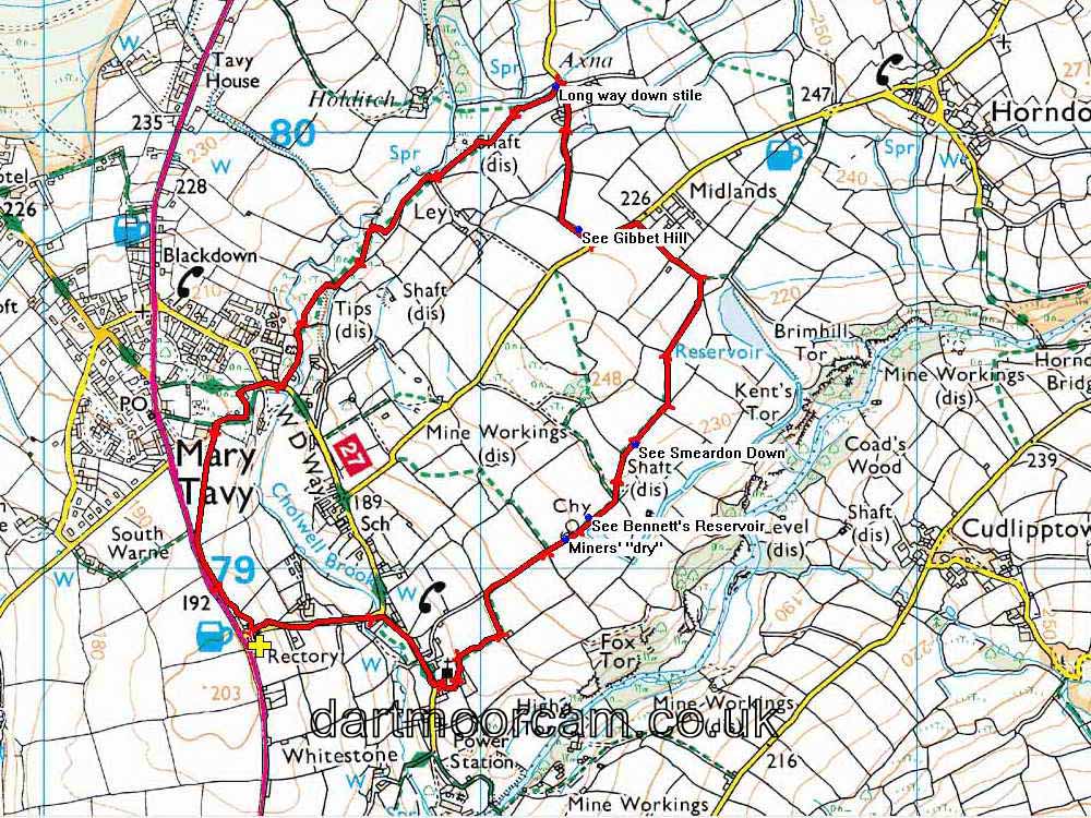
MAP: Red = GPS satellite track of the walk.

This walk started from the car park of the Mary Tavy Inn (with the landlord's permission) which is alongside the A386 road just before reaching Mary Tavy from the Tavistock direction.
Statistics
Distance - 4.67 km / 2.90 miles.
All photographs on this web site are copyright © 2007-2016 Keith Ryan.
All rights reserved - please email for permissions