

This walk: 2015-3-25. Steps Bridge, River Teign, Dunsford Woods, weir, leat, riverside paths, hazel catkins, wild daffodils, robin, blue tit, dipper, mallards, snowdrops, iron mill.
Walk details below - Information about the route etc. Old maps ..... Google Satellite View with GPS track of the walkSteps Bridge, looking away from Dunsford and towards Moretonhampstead, with the entrance to the Dunsford Woods walk on the right.
Other Dunsford Woods links: via Dartmoor National Park, Devon Wildlife Trust, Wildlife Extra, Telegraph.
View looking over the end of the bridge parapet, the River Teign is below.
Notice at the entrance to the woods.
Welcome board ....
Click the image to see a larger version.
National Trust sign.
Sluice near the take-off point on the River Teign for the Dunsford Mills - see photographs of the modern mill at the bottom of this page.
Weir and river scene near Steps Bridge.
Riverside path at the start of the walk.
Bracket fungi growing on the end of a log, originating apparently from the cambium layer - the layer that actively divides to produce new cells: "wood" or xylem cells inside the dividing ring and "bark" or phloem cells outside the ring.
Click the image to see a larger version.
Another view ahead.
Back on the riverside - note the tree roots in the path.
Tree roots seen on the bank across the river.
Photograph taken for the catkins .....
Hazel, Corylus avellana, catkins.
A large pedunculate oak tree, Quercus robur, aka English oak or Common oak. The leaves are lobed at the margin where it joins the stalk and the acorns are borne on stalks ('peduncles').
Another National Trust sign.
Forestry work going on .....
The smoke sometimes flared into flame - with combustion of the hot smoke particles - a form of fire "flash-over".
Reflection on the water .....
Reflection.
The group.
View of a meadow with scattered wild daffodils .....
Another view .....
Wild daffodils, Narcissus pseudonarcissus, also known as the Lent Lily,
Wild daffodils .....
Wild daffodil.
A non-wild variety.
Wild daffodils .....
Daffodils .....
As previous.
Blue tit that wouldn't keep still!
Dipper, Cinclus cinclus.
Those daffodils get everywhere.
River scene.
Click the image to see a larger version.
Mallard ducks, Anas platyrhynchos .....
Duck and drake ......
Zoomed view.
Standing on Steps bridge, where the river splits and forms an island that a support of the bridge stands on.
Snowdrops, Galanthus species, still flowering .....
Close-up .....
Why did I pick a flower that is past it's sell-by date?
A Morris & Sons, The Iron Mills, Dunsford .....
The undershot water wheel - the mills are marked "Mills" on the map just east of Steps Bridge.
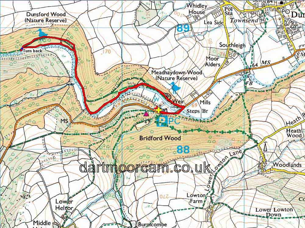
MAP: Red = GPS satellite track of the walk.

This walk was reached from Plymouth via the A38 by turning off after Chudleigh Knighton, this is the Chudleigh turn-off but follow the B3193 Teign Valley road, then the B3212 to Dunsford. Pass the turn-off into Dunsford and follow the road to the bridge. There is parking beyond the bridge with the main area being on the right (SX 803 883), at the the P symbol / yellow cross on the map. There is a small overflow park before this, on the left. There is also some roadside parking just before the bridge, on the right.
Statistics
Distance - 4.61 km / 2.87 miles.
Extra page - Photographs taken beyond today's turn-around point, on the day of the recce (19th March), to the entrance near Clifford Bridge.
All photographs on this web site are copyright © 2007-2016 Keith Ryan.
All rights reserved - please email for permissions