

This walk: 2015-1-7. Two Crosses Stone, Honeybag Tor, Chinkwell Tor, Haytor Rocks, Wind Tor, Rippon Tor, Saddle Tor, mole hills, Drywells Cross, Dockwell, Hutholes medieval village, Corndon Tor.
Walk details below - Information about the route etc. Previous walks in this area: 2009-4-22 and 2012-6-22. The photos on this page were taken during the "recce" on 7th January 2015. Because of the gale and horizontal rain at 10 o'clock, we cut the walk very short, visiting just the medieval village of Hutholes: CLICK HERE to see those photographs on a separate page.The Two Crosses Stone, instigated by the Widecombe History Group, placed where the manors of Dunstone, Jordan, Blackslade & Widecombe border each other. The stone is a donated gatepost and was inscribed by the Dartmoor National Park Authority's stonemason, Andy Cribbet. Originally, the Lord of the Manor of Dunstone had planned to erect either two crosses or a cross with four arms, but he died before it was done. For a long time afterwards, two crosses were cut in the turf each year.
Detail of the fact that this was once a gatepost, an old iron gate hanger, near the top right corner in the previous photograph.
A scratching post, across the road from the car park, with the Two crossess Stone marked by the "V".
View from near Wind Tor to Honeybag Tor (left) and Chinkwell Tor (right) .....
Zoomed view to Honeybag Tor (left), SX 728 786, elevation 445 metres (1459 feet) and Chinkwell Tor (right), SX 729 782, elevation 456 meters (1496 feet).
Zoomed view to Haytor Rocks Haytor, SX 757 770, elevation 457 metres (1499 feet).
Approaching
Approaching Wind Tor .....
On the flat open top of Wind Tor .....
The main rock pile of Wind Tor, at SX 7078 7576, elevation 375 metres (1230 feet) .....
Abandoned attempt at cutting a stone? Or was it that fox that was the devil transformed as he chased across the moor and where he touched the ground, his feet melted it, according to legend?
Wind Tor seen from the south.
Looking back at Haytor Rocks (left) and Rippon Tor (right), SX 746 755, elevation 473 metres (1551 feet).
Zoomed view to Rippon Tor, with summit cairn to the right.
Believed Saddle Tor.
Picturesque wall corner.
Fresh mole hills .....
Closer view of a mole hill.
Walking west along the road towards Drywell Cross .....
Looking back up the hill to Wind Tor .....
Zoomed view.
Further along the road .....
A stream seen along the way .....
Zoomed view.
A small hamlet, not named on the map .....
Closer view .....
The gate on the road.
A line of pollarded trees - what were these?
Closer views - the trees are old and some are hollow .....
Pollarded crown .....
Another hollow trunk .....
Interesting stone in the hedge at Drywell Cross .....
This was probably an old gate-hanger stone.
A once-mighty oak tree is now pruned into a not-so-majestic shape ..... Drywell Cross is seen to it's left .....
Drywells Cross - a cross with a chequered history of being lost and found again. It was a waymarker to Widecombe church and was restored in 1967 by Dartmoor Preservation Association - the replacement shaft matches the cross head in that all limbs are octagonal in cross section .....
Closer view - the purpose of the cavity is not known although one suggestion is that it held a small crucifix or image that could have been easily destroyed if necessary, leaving the cross intact.
A callus formed over the scar formed when a branch was sawn from the tree .....
Another view .....
A close-up photograph .....
Another callus .....
Another view.
Approaching Dockwell .....
Dockwell hamlet.
Row of sycamore trees just up the road from Drywells Cross .....
Another large tree seen along the way.
Notice inside the entrance to Hutholes medieval village - this part of Dockwell Farm ..... Click on the image to see a larger version.
The main display board at the site ..... Click on the image to see a larger version. The Saxon Period in Britain was from the 5th to 11th Centuries i.e. the 400's to 1,000's AD. Therefore this village was occupied by Saxon Britons at the time of the Norman Conquest in 1066, led by William the Conqueror.
Panorama of the village ..... Click on the image to see a larger version.
House 1 (following the labelling on the notice) .....
Zoomed view to a fireplace?
Possible remnants of three fireplaces used for drying corn, or are they supports for a raised floor area?
House 6, converted to a barn .....
House 3, believed to be, up to the 12th century, the original Dewdon (now Jordan) manor house, now resited half a mile away. In the Domesday Book (1066 AD), it was owned by a wealthy Englishman caled Alric; by 1086 it had been relinquished to one of the conquerors, William de la Falaise (Butler, Vol. 1 page 142).
Looking down the site at House 2, later converted into a small barn - the main display board can be seen at the far end .....
Part of House 6 and a gateway into adjoining (private) fields .....
Part of the main display board .....Click the image to see a larger version.
Unidentified lichen on blackthorn .....
As previous photograph .....
As previous photograph .....
View south-west to Corndon Down .....
Corndon Tor, SX 687 742, elevation 434 metres (1423 feet).
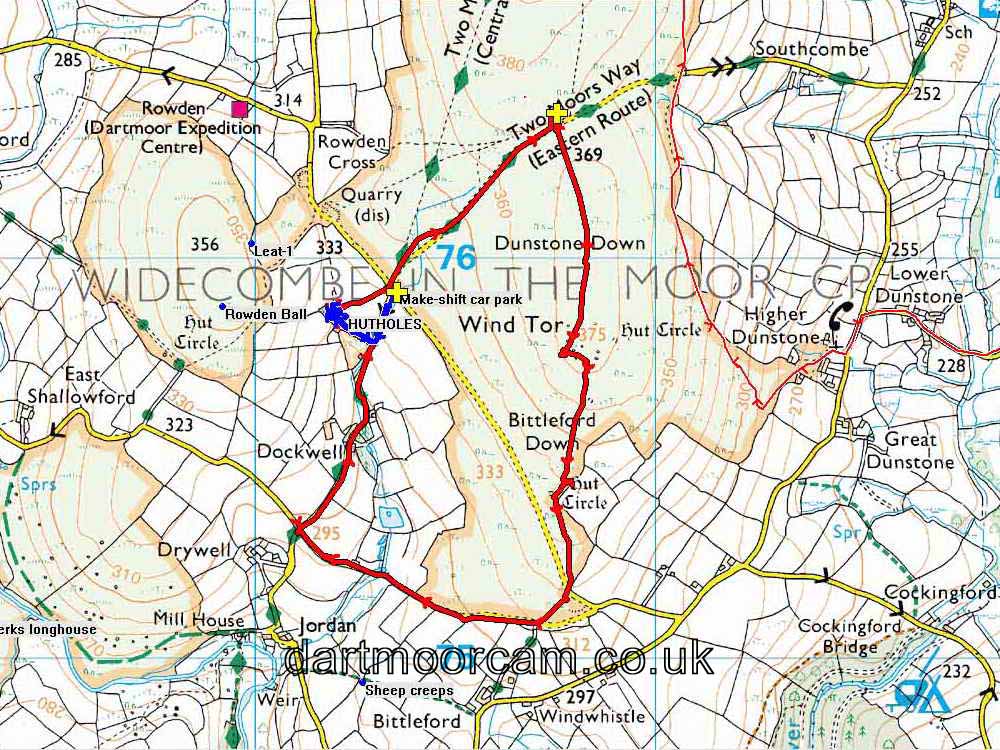
MAP:Red = GPS satellite track of the walk.

This walk was reached by driving south-west out of Widecombe, taking the first road on the right, going west, uphill past Southcombe, and parking on the right just over the brow of the hill at the yellow cross symbol on the map.
Statistics
Distance - 4.08 km / 2.54 miles.
All photographs on this web site are copyright © 2007-2016 Keith Ryan.
All rights reserved - please email for permissions