

This walk: 2014-3-5. Mary Tavy/Brentor parish boundary stones, West Devon Way, Brentor, Church of St Michael de Rupe, Brentor Station, Whittor, Great Mis Tor, Roos Tor, Great Staple Tor , Cox Tor, Sharpitor, Peek Hill, mine shaft, trig pillar, Great Links Tor, Widgery Cross (on Brat/Brai Tor), Lydford Station, Wastor Farm.
Walk details below - Information about the route etc.
Link to Google Satellite view of the area
Similar walks in this area: 27 Jan 2010, 9 Nov 2011, 2 Aug 2012 and 15 Feb 2013.
Mary Tavy/Brentor modern boundary marker beside the car park .....
Erected in the year 2,000.
The road beside the car park at West Black Down.
Marker post near the car park for the 37-mile long West Devon Way.
View to Brentor and St Michael de Rupe (details can be seen on the page for 2 Aug 2012) .....
Zoomed view.
Looking down on Brentor Station (disused), the cottages behind may have been railwaymen's cottages? .....
Closer view .....
Zoomed view of the old Brentor Station: Brentor railway station was on the Plymouth, Devonport and South Western Junction Railway's line from Lydford to Plymouth, between Lydford and Tavistock. It opened on 2 June 1890 and closed on 6 May 1968. Wikipedia. We will also see the old Lydford Station on this walk.
A feature cairn on the fairly featureless West Black Down.
Zoomed view to some gorse on the featureless Down!
Tors, from the left: Whittor, Great Mis Tor (with Little Mis Tor), Roos Tor, Great Staple Tor (with the "hollow"), Cox Tor. To the right, in the background, is Sharpitor and Peek Hill. Click on the image to see a larger version.
View across the Down to Brentor church.
Triangulation pillar up ahead.
Zoomed view to nearby mineshafts.
Approaching the trig. pillar on the summit of Gibbet Hill, SX 503 811, elevation 353 metres (1158 feet).
Group at the trig. pillar.
Zoomed view to Great Links Tor, SX 5511 8675, elevation 589 metres (1922 feet), with Widgery Cross on Brat/Brai Tor below, at SX 539 855, elevation 452 metres (1482 feet).
Lyford railway station (disused): the station, known then as "Lidford", was opened on 1 June 1865 with the Launceston and South Devon Railway, 7 ft � in (2,140 mm) broad gauge line that connected with the South Devon and Tavistock Railway to offer a service toPlymouth Millbay railway station. This line eventually became a part of the GWR Lydford railway station was a junction at Lydford between the Great Western Railway (GWR) and London and South Western Railway (LSWR) situated in a remote part of north-west Dartmoor in Devon, England. Wikipedia.
Wastor Farm.
Another view.
The way back .....
As previous photo, at SX 50086 82502.
Another modern boundary stone, at SX 49952 82438 .....
The reverse face showing "B", signifying the Parish of Brentor.
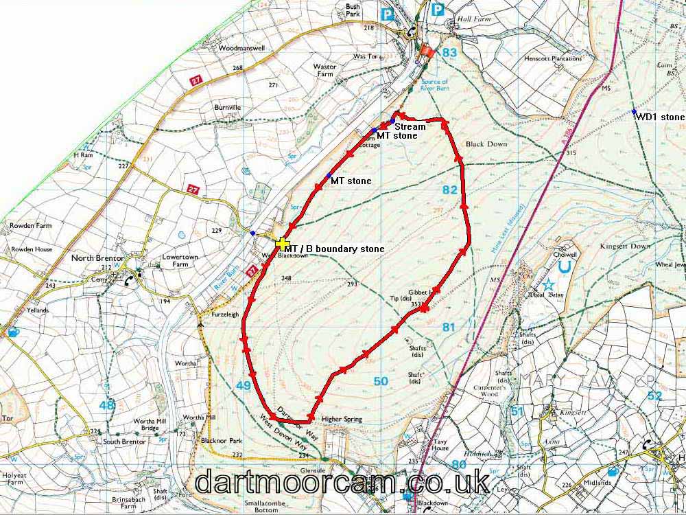
MAP: Red = GPS satellite track of the walk.

© Crown copyright and database rights 2012 Ordnance
Survey
Licence number 100047373
Also, Copyright © 2005, Memory-Map Europe, with permission.
This walk was reached by driving from Tavistock to Mary Tavy and turning left by the old CJ Down garage. This road was followed to the roadside parking area indicated by the yellow cross on the map.
Statistics
Distance - 6.21 km / 3.86 miles.
All photographs on this web site are copyright ©2007-2016 Keith Ryan.
All rights reserved - please email for permissions