

This walk: 2014-12-10. Long Ash car park, Middle and Great Staple Tors, Great Mis Tor, Pew Tor, bench, hawthorn, ponies, Brent Tor church, Iron Age Castle Field, Berra Tor, Orange Peel Fungus.
Walk details below - Information about the route etc.
Previous walk in this area: 27th May 2009 - not a lot too see, it was early web days then!
Walking out from the car park opposite Long Ash Garden Centre (Yelverton) car park - soggy on the level!
View of Middle Staple Tor, SX 5403 7564, elevation 431 metres (1414 feet), Great Staple Tor, SX 542 760, elevation 455 metres (1492 feet) and Great Mis Tor, SX 563 769, elevation 538 metres (1765 feet), with Pew Tor in front, SX 532 734, elevation 318 metres (1043 feet).
Bench.
Plaque on a bench looking at the view of the tors above.
Winter outline of a hawthorn tree.
Mare and foal.
Wandering foal .....
Zoomed view.
Great Mis Tor - and far right, Little Mis Tor.
Brent Tor ..... with the Church of St. Michael de Rupe.
Zoomed view - note the bracken-covered flank.
Gorse flower.
The way ahead - way open!
Dying bracken under hawthorn.
Hawthorn berries, rather a light crop in this area, not good for birdlife if the winter is hard.
Another aspect of the way ahead - open down.
Now more of a path through hazel trees.
One fir tree, marking a shortcut between paths.
Yet another view ahead.
Overlooking Buckator (far right), and other properties, that was reached on 29th October 2014 ..... with West Down behind
Buckator .....
Another dwelling .....
.... and another.
View to West Down, mostly covered with bracken.
Ponies under a summer shade tree.
Dartmoor white-faced ewe .....
This looks like a Kerry Hill sheep but is most probably a variant of the common Scottish Blackface - check breeds HERE.
On the left is the wall of Castle Field, an Iron Age fort (British Iron Age) feature with the photograph taken standing in the surrounding ditch.
Approaching Berra Tor from the east, SX 47800 69056, elevation 134 metres (439 feet): this is the third lowest tor on Dartmoor (Source: K Ringood (2013), Dartmoor's Tors and Rocks, University of Plymouth Press, page 29) .....
View from the south .....
View from the north .....
The rock is not granite but does not look like the granite that occurs across the valley.
View from the south.
Berra Tor conquered just in time for Christmas ........... ah, or am I thinking of Everest and 1953 .....
Someone was persuaded to strike an elf-like pose!
As far as we know, he's still there.
A likely bunch - before striking out on the return leg for the Walkhampton Inn.
Foal, resting .....
Zoomed view.
Strange orange fungus growing on bare earth in a mud track at SX 47737 69124 .....
Another, more curly version, there are quite a lot of patches of this fungus along this track (travelled only during the "recce" of the walk) .....
Here is the giveaway, looking like orange peel, this is Aleuria arantia, the Orange Peel Fungus.
Silhouette of an oak tree.
His 'n' hers drinking troughs, permanently plumbed in for livestock on the down.
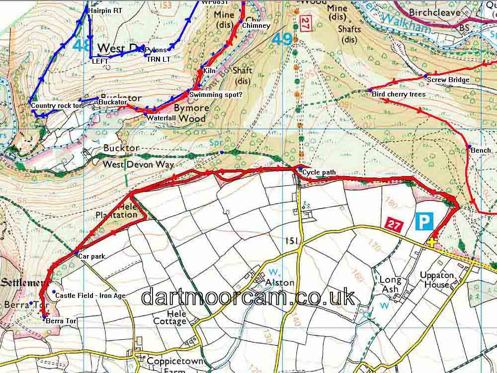
MAP: Red = GPS satellite track of the walk. Today's walk is the bolder of those that can be seen, in the bottom of the map. There are sections of two recent walks (1) 29th Oct. 2014, from Grenofen and (2) 24th Sep. 2014 from Bedford Bridge.

Access to this walk was along good roads from Yelverton to the car park opposite Long Ash Garden Centre, at the park with the yellow cross and the P symbol on the map.
Statistics
Distance - 5.91 km / 3.67 miles.
All photographs on this web site are copyright © 2007-2016 Keith Ryan.
All rights reserved - please email for permissions