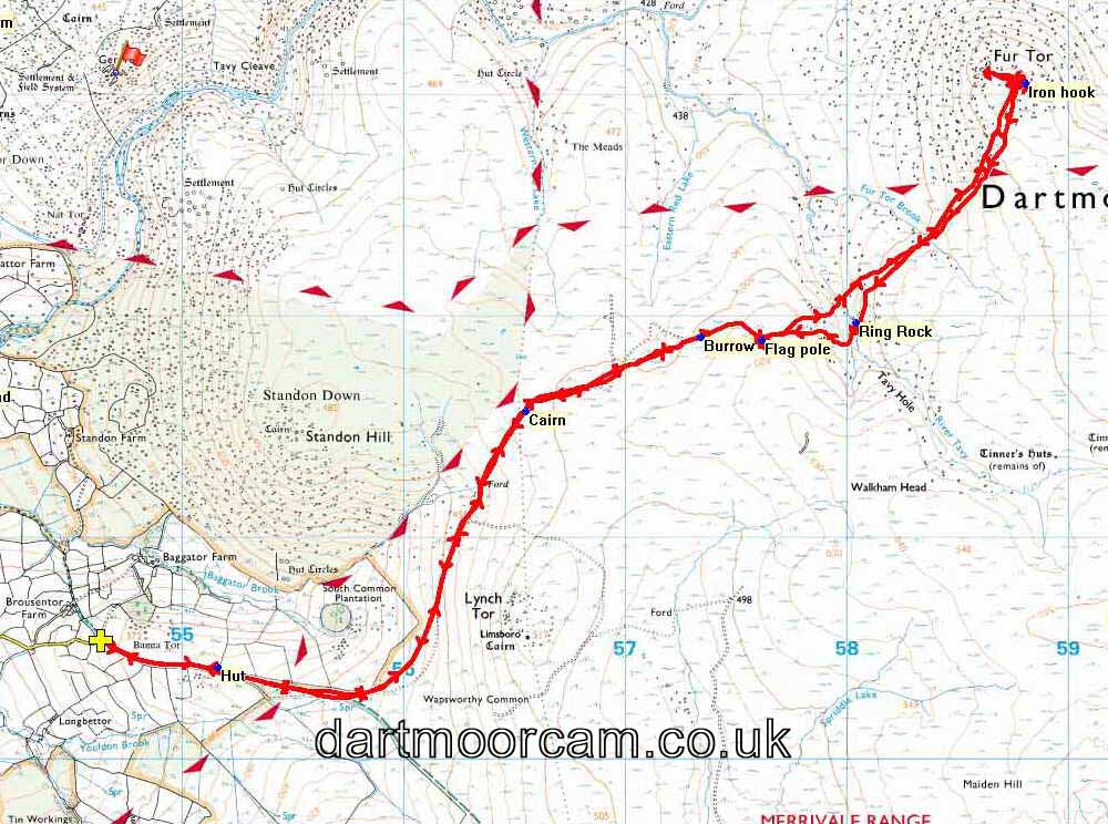


This walk: 2014-10-2. Bagga Tor car park, military huts, small cairn, Ring Rock, Amicombe Brook, Fur Tor Brook, River Tavy, Fur Tor.
Walk details below - Information about the route etc.
Google Satellite view of the area - including the GPS track of the walk (compare with the Ordnance Survey map plus track below)Previous walk in this area: 11th August 2013.
Military notice at the Bagga Tor car park. Click the image to see a larger version.
Bagga Tor car park, with Ger Tor and Hare Tor in the distance.
Ger Tor (centre), SX 546 830, elevation 430 metres (1410 feet) and Hare Tor (right), 550 842, elevation 531 metres (1742 feet)
Ger and Hare Tors.
Hut on Standon Hill.
What shows as a dashed trtack on the map - a peat cutters' track?
Small cairn at SX 56547 81571 - there are not many landmarks in these parts! We met a man in the Mary Tavy Inn who told us that he started this cairn, it marks the place where you get the first sight of Fur Tor.
At the flagpole (SX 57615 81891), looking at Fur Tor.
Fur Tor.
As previous photograph.
Looking northwards up Amicombe Brook with the River Tavy running in from the right.
Ring Rock at the head of the bend in Tavy Hole (mentioned in Hemery, pages 888 & 975, but with no detail other than there being a tethering ring) .....
Ring Rock from a different angle, with a marker to show the horse tethering ring (photo borrowed from previous walk on 11th Aug. 2013..
Fur Tor Brook.
Approaching Fur Tor.
Fur Tor.
Fur Tor.
The rocks at the head of the clitter below Fur Tor coming up from Amicombe Brook and Cut Combe Water.
Fur Tor.
Fur Tor rocks with Hare Tor in the distance.
Another view from Fur Tor.
Looking down towards Tavy Cleave with a small section of the River Tavy visible, approaching Sandy Ford.
Fur Tor.
Fur Tor rocks - with stereo logan stones?
Fur Tor.
Fur Tor.
One side of signpost ..... Merrivale .....
The other side ..... Okehampton.
MAP: Red = GPS satellite track of the walk.

This walk was reached by driving to park at Baggator Gate, at SX 54632 80553. This was done by driving through Peter Tavy and Cudlipptonw and on via Wapsworthy to the end of the road.
Statistics
Distance - 12.6 km / 7.83 miles.
All photographs on this web site are copyright ©2007-2016 Keith Ryan.
All rights reserved - please email for permissions