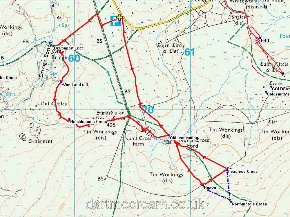


This walk: 2013-8-14. Devonport Leat, clapper bridge, spillway, Drivage leat hut, Hutchinson's or Devonport Leat Cross, leat tunnel, dung bonnet, Old Smithy, Nun's Cross Farm, Northmore's Cross, Headless or Whealham Bottom Cross.
Walk details below - Information about the route etc.
Link to Google Satellite view of the area - including the GPS track of the walk (compare with the Ordnance Survey map plus track below)
Bing and Google maps side by side - but no GPS track.
Other walks in this area: 27 December 2008, 14 October 2009, 4 March 2010, and 18 July 2012.
Self-explanatory notices, seen near the car park.
Devonport Leat clapper bridge at SX 59819 70551 .....
As previous photograph.
Sluice/spillway close to SX 5990 7040 .....
As previous photograph. This is near the Newleycombe watershed, one of the most extensively tin-worked areas, with docum,entation from 15th. Century.
A neglected stretch of the leat, with silt, weed and bank damage .....
Leat bank falling in.
Drivage leat hut, one of the few remaining huts on the leat .....
As previous .....
As previous .....
As previous - an un-"fettled" photograph .....
A "fettled" photograph - this was a very mistry and wet day.
A new sluice valve and gear! Locateed just before Hutchinson's Cross (see following) .....
As previous photograph .....
As previous.
Hutchinson's or Devonport Leat Cross.
The cross was erected in 1968 by Lt. Commander B. Hutchinson R.N., as a memorial to his mother, Mrs S.L. Hutchinson .....
Western face of the pillar, near the bottom, "SLH" .....
Eastern face of the pillar, "1887 - 1966".
A parting view.
Devonport Leat exiting the tunnel near Nun's Cross, built in the 1890's -the leat was built 1793-1801. The tunnel is 700 yards (640 metres) long.
View from the lip above the tunnel.
By special request: Dung Bonnet (Bolbitius vitellinus), a coprophilous fungus that breaks down dung. These are larger and more delicate than Dung Roundheads (Stropharia semiglobulata).
The Old Smithy, or The Smithy's Shop i.e. the blacksmith's emporium at SX 60163 69915 .....
View from the west ..... look at the rain!
View from the east, quickly taken as it was zinging down at the time!
Nun's Cross Farm .....
As previous photograph.
The group then visited this feature .....
Northmore's Cross - a personal cross at SX 61351 69203 � 5 metres, made from a brass ship's propeller, check the link for more details. Clearly, this photograph was taken in better weather, on 14 October 2009. Unfortunately, the cross has now been vandalised.
Another clapper bridge and nearby sluice.
Headless or Whealham Bottom Cross, probably erected as a boundary marker for the sett of the nearby Wheal Anne mine: it is on no recognised route marked byb crosses .....
Close-up of the inscribed cross - some could see a second, smaller cross above the obvious one?.
Rear face of the cross with seemingly nothing inscribed.
MAP:
Red = GPS satellite track of the walk.

© Crown copyright and database rights 2012 Ordnance
Survey
Licence number 100047373
Also, Copyright © 2005, Memory-Map Europe, with permission.
This walk was
reached, from Plymouth, by turning right, down Tor Royal Lane, after the mini-roundabout in Princetown, after the Plume of Feathers public house and driving down to the quarry marked by the yellow cross and the P symbol on the map.
Statistics
Distance - 5.56 km / 3.46 miles.
All photographs on this web site are copyright ©2007-2016 Keith Ryan.
All rights reserved - please email for permissions