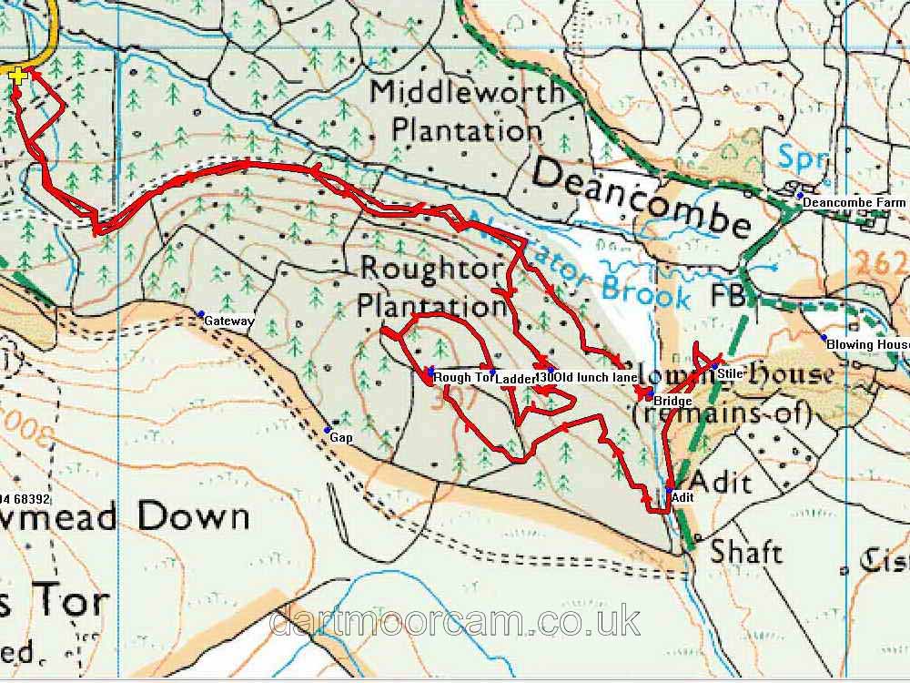


This walk: 2013-6-6 Narrator Brook bridge, gate and stile, Sharpitor, Leather Tor, Down Tor, adit, Cuckoo Rock, Rough Tor, bluebells, Sheeps Tor, Meavy, oak tree. Royal Oak pub.
Walk details below - Information about the route etc.
Link to Google Satellite view of the area
Bridge over Narrator Brook at SX 57735 68524, the far end of the plantation.
Gate and stile at SX 57821 68563, this is the fence at the far end of the wood from the car park.
Zoomed view.
The area near the gate, taken to show the patches of bluebells.
Sharpitor, SX 560 703, elevation 410 metres (1345 feet), zoomed view .....
Non-zoomed view.
Sharpitor (right) with Leather Tor, SX 563 700, elevation 380 metres (1246 feet), at left.
Down Tor (SX 580 694, elevation 366 metres / 1200 feet) seen across Roughtor Plantation .....
Zoomed view to Down Tor.
Stream running from the adit ..... an easy access stile is located to the top left of the photograph (out of view) .....
Adit, at SX 57759 68392 .....
Close view.
Zoomed view to Cuckoo Rock, SX 58470 68723.
The recently emergent Rough Tor, visited 18 Nov. 2011, when it was hidden by a fir tree, and again on 28 Feb. 2012, when it was uncovered with permission from South West Lakes Trust.
Common Bluebell (Hyacinthoides non-scripta) other names: Endymion non-scriptum, Scilla non-scripta and Agraphis nutans .....
Bluebell .....
Bluebell.
Rough Tor.
That's about the size of it!
A track through the wood .....
When we found .....
A daredevil bike-riding course .....
Going up .....
Following behind .....
Showing off .....
Another construction, this time with a jump!
Another track.
Sheep's Tor, SX 565 682, elevation 369 metres (1210 feet) from the Arboretum car park .....
Zoomed view.
Somewhere along the walk, two samples of leaves were collected from large, mature trees (above); ordinary beech, Fagus sylvatica. At first, it was thought that the two leaves might be from different species of tree, but apparently not, natural variability in beech leaf size is from 5 to 10 cm in length.
Meavy war memorial .....
Ancient oak tree at Meavy ..... recorded under the Woodland Trust's Ancient Tree Hunt as Tree 27350 .....
The trunk has seen better days .....
Meavy Village Cross .....
General view of the village green ......
As previous photograph .....
The Royal Oak pub,
Final view.
Red = GPS satellite track of the walk.

© Crown copyright and database rights 2012 Ordnance
Survey
Licence number 100047373
Also, Copyright © 2005, Memory-Map Europe, with permission.
The walk was accessed from the B3212 road from Yelverton to Dousland, turning right to Burrator Dam, driving past Norsworthy Bridge to the Arboretum car park at the yellow cross on the map. There is a shorter route by going over the dam and turning left before Sheepstor village - the roads here are quite narrow.
Statistics
Distance - 4.63 km / 2.88 miles.
All photographs on this web site are copyright ©2007-2016 Keith Ryan.
All rights reserved - please email for permissions