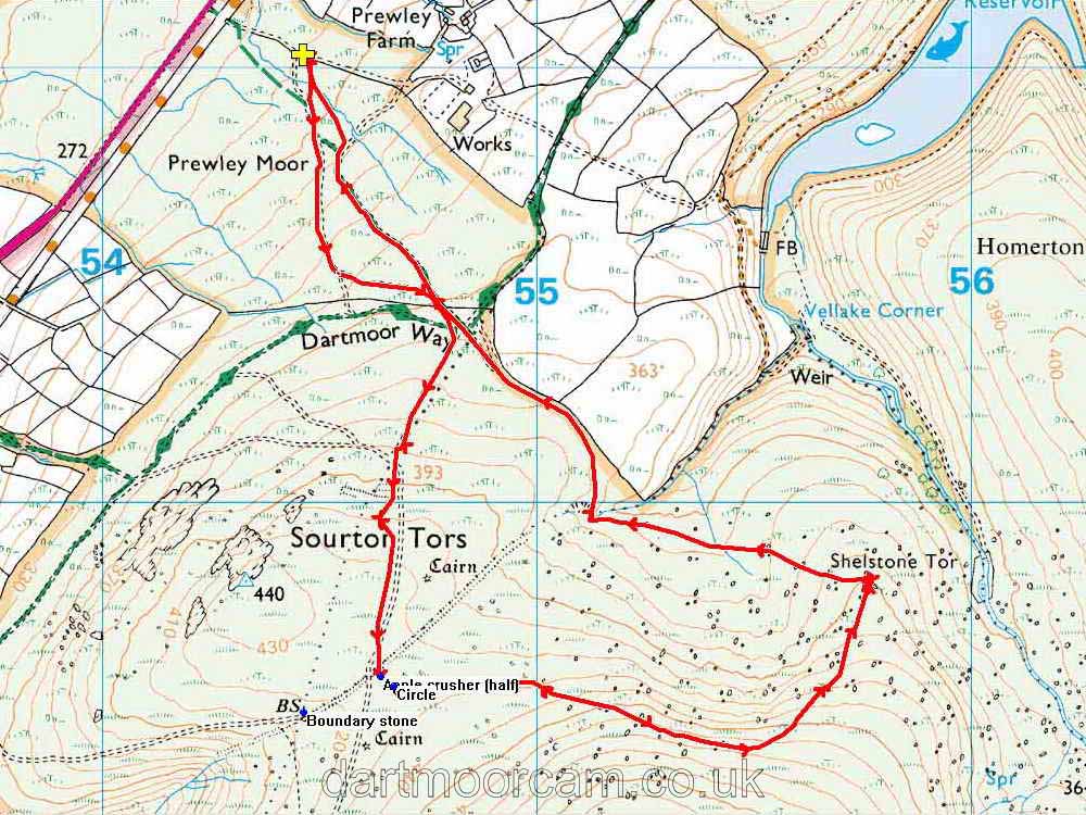


This walk: 2013-6-5. Sourton Tors, marker stones, King Way, SWW water works, ice works, Meldon Reservoir, boundary ditch, apple crusher, Pixies' matchsticks, Meldon dam, Shelstone Tor, luggage "handle" on a large rock, non-logan stone, Vellake valley, Greep Quarry.
Walk details below - Information about the route etc.
Link to Google Satellite view of the area - the car park is in the upper left area, on the track up to the water works.
Heading towards Sourton Tors, SX 543 898, elevation 440 metres (1443 feet).
As previous photograph, with a possible tinners' trial pit in the foreground.
Two posts marking the King Way, this was a fast mail delivery route for several hundred years, using high, dry ground from the Exeter direction towards the west.
South West Water's Prewley Water Works, at SX 548 908.
Showing two of five reservoirs of the Sourton Ice Works, 3-feet deep, lined with bricks or concrete. These are on a cold, north-facing slope, fed by a spring, where winter weather was meant to freeze the water. Ice was largely used by fishmongers and was removed by horse and cart, some to Bridestowe Station for train transport to London and South western Railway. The entrepreneur was James Henderson, a successful civil engineer, respected in mining circles. The venture lasted from about 1875 until about 1885 (Hemery, page 932).
Google Earth view of the ice works.
The right-most reservoir seen in the preceding photograph, with Sourton Tors in the background.
Zoomed view to Meldon Reservoir.
Another view along an ice reservoir, showing it curving along the contour. Locally, there were known as the ice pits.
Ancient boundary ditch, at SX 54635 89608 .....
One half of an abandoned apple crusher, SX 54642 89599 .....
Another view .....
The telling of the story .....
As previous photograph.
32-metre diameter stone circle, SX 54672 89578. There are 18 stones, 5.5 metres apart, all flat but mostly with one edge still embedded in the ground. Click on the image to see a larger version.
Possibly the red tipped fruiting bodies of Cladonia floerkeana, known locally as Dartmoor matchsticks, pixies' matchsticks or as devil's matches - this species is very like a matchstick. Alternatives would be C. diversa (fruiting stalk is branched), C. macilenta (red tip is very narrow compared to diameter of the stalk) and Dibaeis basomyces (fruiting bodies are short and fat). Several Cladonia species can be seen here. It is possible that a fruiting stalk upper left of centre is branched.
As previous photograph.
Another view to Meldon reservoir .....
The dam is 2.4 km (1.49 miles) distant .....
Fully zoomed view.
Dartmoor CAM movie.
TIP .....
A video panning from Corn Ridge, to the right, showing Sourton Tors (zooming closer), looking down to Shelstone Tor (with Homerton and Longstone Hills behind), zooming towards Yes Tor at the end. |
Click the photo to download File size: 5.8 MB. Length 36 secs |
Sourton Tors, again.
Looking down on Shelstone Tor, at SX 557 898, elevation 400 metres (1312 feet) .....
In sunlight, with cloud shadow behind .....
On this day (or thereabouts) in 1953, Everest was conquered by Edmund Hilary and Sherpa Tenzing Norgay. On this day, this year, it was Shelstone Tor, by Sherpa Mac .....
See?
Casual view of the walking group.
Strange feature around the back of the tor, a luggage "handle" for easy moving of this large boulder .....
Closer view, formed probably by water erosion .....
Another view.
Is this a logan stone? .....
Are we sure if its a logan stone? .....
Let's try this end .....
After "three" we'll jump again!
It didn't really move.
Zoomed view.
Rock pile at Shelstone Tor, note the inclination of the bedding planes?
Shilstone Tor, with Yes Tor (with military firing range flag pole) behind.
Looking down Vellake, a quite dramatic re-entrant valley.
Greep Quarry, at SX 551 899, that yielded slatey border rock that was used in Sourton village, in the Victorian vicarage and the Wesleyan chapel. The stone was removed by cart track to the village.
Red = GPS satellite track of the walk.

© Crown copyright and database rights 2012 Ordnance
Survey
Licence number 100047373
Also, Copyright © 2005, Memory-Map Europe, with permission.
This walk was reached via the main A386 Tavistock-Okehampton road, turning off at the brown "Granite Way" sign shortly after leaving Sourton while travelling towards Okehampton. Parking is at the yellow cross symbol on the map.
Statistics
Distance - 5.53 km / 3.44 miles.
All photographs on this web site are copyright ©2007-2016 Keith Ryan.
All rights reserved - please email for permissions