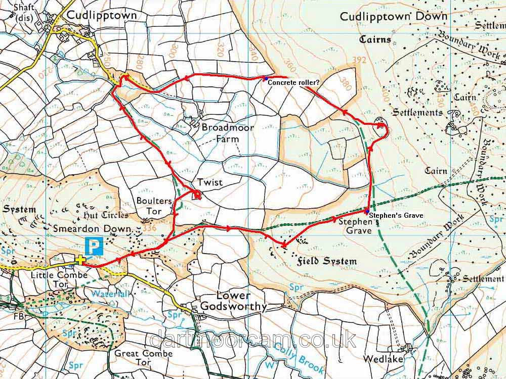


This walk: 2013-6-12. Setters Tor, non-granitic rock, Stephen's Grave, Bronze Age settlement, conrete roller, Broadmoor Brook, sheep creep, slotted gate post, Twyste Farm, Boulters Tor.
Walk details below - Information about the route etc.
Link to Google Satellite view of the area - the car park is at bottom left (near the scale bar) and Twyste Farm is at top right.
Previous walks in this area: 11 Feb. 2009 (near-identical walk), 29 April 2009, and 23 March 2012 (same start but more to the south),
Setters Tor, SX 532 779, elevation 360 meters (1181 feet).
Waiting in the mist, wind and rain for other jolly fellows to join us!
Now here's a thing, it's not granite: it is metamorphic aureole or "country" rock that makes up the rock surrounding the granite mass of Dartmoor. A fairly simple DNPA geological map suggests Lower Carboniferous rocks or dolerites - it is difficult to be certain without any means of accurate position-finding on the map. The more elaborate BGS inter-active map suggests: hornfelsed slate, basaltic metalava and metatuff, and Carboniferous/Devonian silica - possible igneous intrusion that was later metamorphosed, but into what?
More of the same!
Stephen's Grave, SX 53590 78121, the story of John Stephens (although some say George Stephens) of Godsworthy can be read on Legendary Dartmoor - Stephen's Grave page. He fell in love with Mary Bray of Wedlake and for whatever reason (rejection by her or by her parents or because she loved another) he committed suicide by eating deadly nightshade. There is a description somewhere of his awful illness and dying in the night. As was the custom with suicides, they were not to be buried in hallowed ground but rather away from habitations, often out in wild country beside a crossroads so that their spirits would be confused and would not find their way back to bother and haunt the living ..... Source: Mike Brown's CDROM "Guide to Dartmoor" (2001) .....
Discussing the merits of the case?
Another view.
An attempt to show that the grave is beside a crossing of tracks - it was raining .....
One last photograph.
SX 53655 78528, a Bronze Age settlement of six round houses, described by Jeremy Butler, 1991, in Dartmoor Atlas of Antiquities Vol. 2 - The North: 31.12 - White Tor West (fig. 31.6), page 90. The settlement was excavated by Dartmoor Exploration Committee in 1898 or 1899, with "poor results".
|
|
An apparent concrete roller at SX 53092 78778 - or a wheel off Wilma's shopping trolley as one wag would have it!
Another view.
Preparing to cross the mighty Broadmoor Brook, at SX 52347 78728 .....
There is actually a small clapper bridge for the purpose.
The lane ahead.
Somewhere just across the stream is this rock with vent holes?
A sheep creep - there's a fancy one at the bottom of this Yorkshire page!
Slotted gate post where wooden laths were originally used to close fields .....
More detail can be found on Legendary Dartmoor's Gateways page.
Approaching Twyste Farm ..... there is a row of large stones here as well as a pile beside the gate from the time when a couple planned to build a house in a day. thereby establishing an old right to stay there - I believe in West Cornwall they had to have a fire burning in the grate by nightfall. The couple were discovered and stopped by local people. I believe in West Cornwall, friends were allowed to help in the building.
Twyste Farm is named by William Crossing (1912, reprinted 2001) Crossing's Guide to Dartmoor, Peninsula Press, Newton Abbot, page 39, in a list of the venville places on the moor. "Venville" is a term derived from fines villarum meaning rents of the "towns" (= settlements) i.e. certain farms that bordered onto the moor. These were small fees for exercising the rights of pasturage and turbary (cutting peat). These may predate the the defining of the Forest of Dartmoor (by perambulations in 1240 and 1609) and may go back to Saxon times (5th Century). The tenants could take anything they needed from the Forest, except for oak and venison.
This building is in a poor state and in need of a lot of attention if it is to survive.
Rear view.
An outcrop of Boulter's Tor .....
Boulters Tor, SX 525 780, elevation 336 metres (1102 feet) ...... un-retouched photograph, showing what the weather was like today .....
Cropped and digitally filtered etc .....
..... but it doesn't make up for good weather! This photograph was taken on the 23rd May 2012, with Boulters Tor behind..
MAP: Red = GPS satellite track of the walk.

© Crown copyright and database rights 2012 Ordnance
Survey
Licence number 100047373
Also, Copyright © 2005, Memory-Map Europe, with permission.
The walk was reached from Plymouth on the A386 via Tavistock to Peter Tavy. The roads off the main road are typical Dartmoor lanes, becoming quite narrow into Peter Tavy. After passing the church on your left, turn right up onto the moor and park in the small quarry, marked by the yellow cross and the P symbol on the map.
Statistics
Distance - 5.3 km / 3.29 miles.