

This walk: 2013-12-4. Master Rock (Billy Bray). Zoar Common, cottages, The Old School House, Hill Brisdge, head weir, leat takeoff, salmon ladder, tin mine, wheelpit, C-stone, Wheal Frederick Leat, tramway rail, linhay, old chapel, Methodist chapel.
Walk details below - Information about the route etc.
Link to Google Satellite view of the area - including the GPS track of the walk (compare with the Ordnance Survey map plus track below)
Bing and Google maps side by side - but no GPS track.
Similar walk in this area: 2 Sep. 2009 (walked north), 11 August 2010, 19 July 2012 (walked north).
The area of Master Rock from which Wesleyan Methodist Billy Bray (b.1794 d.1868) preached to local tin miners.
Zoar Common, scattered with stones.
Zoar Cottages.
Seen between Creason and Hill Bridge, alongside Chilly Wood and before Hill Bridge Farm.
Approaching The Old School House .....
The old well .....
Plaque on the gable end .....
Self-explanatory plaque .....
Last view.
Overlooking Hill Bridge (on the River Tavy) with its leat head weir and salmon ladder (enabling fish to overcome obstacles to their journey up-river).
Another view of the arrangement .....
Hill Bridge, with a caged ladder down to the river (there is also a gated path) .....
The bridge, complete with drainage points no doubt in case of the river level rising when in spate, and perhaps also to allow heavy rain to run off from coming down the hills on each side of the bridge .....
The salmon ladder
Taking off the old Wheal Friendship Leat from the head weir that now supplies the Mary Tavy (Hydroelectric) Power Station.
The P stone? Actually, a C stone, signifying a County stone, about 100 metres (meant to be 100 yards) from the bridge. These date possibly from the 1600's when the County took responsibility for maintaining bridges and the roads approaching from 100 yards in each direction. The concept dates from Henry VIII and the dissolution of the monasteries, when the Statute of Bridges was introduced in 1581. The Dartmoor C stones are listed on Legendary Dartmoor - The County Stones. "The act required that for every bridge the road over it and for 300 ft on either side should be similarly maintained (Source: Legendary Dartmoor, but my underlining - Ed).
Apparently deceased fox on a woodpile, with dew on it.
The old wheelpit of Hill Bridge Mine just off the end of the bridge (north end, upstream) that housed a 40-ft wheel.
View looking back along the leat. It is near here that an acquaintance has bought Common Wood, on the left bank (as viewed here). Dartmoor Preservation Association has laboured here on two occasions (on 19 November 2012 and 12 February 2013) - the first in torrential rain!
It was somewhere along the leat that a rather large(?) dark fish caught our attention:' it may have been a Gudgeon (Gobio gobio) or a Bullhead (Cottus gobio) -it was a fish with low-set, spreading pectoral fins. .
A section of the leat bank showing its construction (in some lengths).
Old tramway rails used as fencing.
Looking down the green lane at SX 5212 7967: I have passed the south end of this lane a few times and looked wonderingly down it - now I know"
A form of Polypody (a fern): usually we see Common Polypody (Polypodium vulgare), Britain also has Southern Polypody (Polypodium australe aka cambricum) with slightly toothed fronds (but not here) and Intermediate Polypody (Polypodium interjectum Shivas). I am wondering if this might be the latter because the fronds are not so wide halfway along their length, Common Polypody frond are a bit more "pear-shaped". Source: Roger Phillips (1994 edition) Grasses, Ferns, Mosses and ichens of Great Britain, MacMillan, p. 105. There are also a number of hybrids. Source: James Merryweather(2007 edition) The Fern Guide, Field Studies Council, pp. 50-51.
Maidenhair Spleenwort (Asplenium trichamanes), with the black stems.
Linhay passed along the way .....
At this farm.
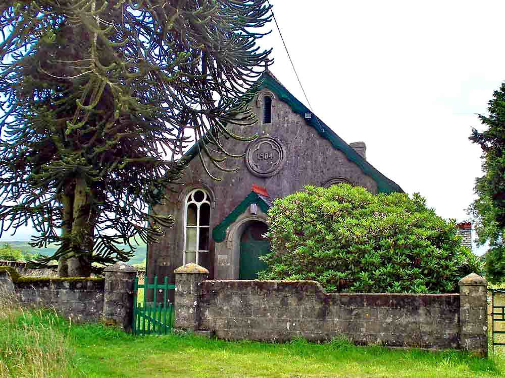
Zoar old chapel ..... this red tractor is presently seen in the Google street view!
Old chapel bell tower .....
Another viewof the chapel.
Farm passed along the way.
Photo from 11 Aug 2010 - I
forgot to get a photograph of the chapel today .....

Zoar Bible Christian Church / Methodist Chapel, built in 1904 as one of the last Bible Christian Churches to be built, becoming a Methodist Chapel in 1932.
Unusual inset stone(?), one of several around the outside of the building. Are they all memorials or perhaps marks of benefactors who donated to the building of the chapel?
Flowers on graves in the churchyard ......
A none-too-good view of the churchyard.
A ramp(?) seen near the Zoar cottages, perhaps a loading ramp or used for dumping something?
MAP: Red = GPS satellite track of the walk.

© Crown copyright and database rights 2012 Ordnance
Survey
Licence number 100047373
Also, Copyright © 2005, Memory-Map Europe, with permission.
This walk was reached from the A386 Tavistock-Okehampton road by turning off at the Mary Tavy Inn (just south of Mary Tavy), following the road down over a small bridge, bearing left, turning right to Horndon (passing the Elephant's Nest pub on the way), following the road to Zoar Cottages and parking just opposite on the rough track, marked by the yellow cross on the map.
Statistics
Distance - 4.99 km / 3.10 miles.
All photographs on this web site are copyright
� Keith Ryan.
All rights reserved - please
email for permissions