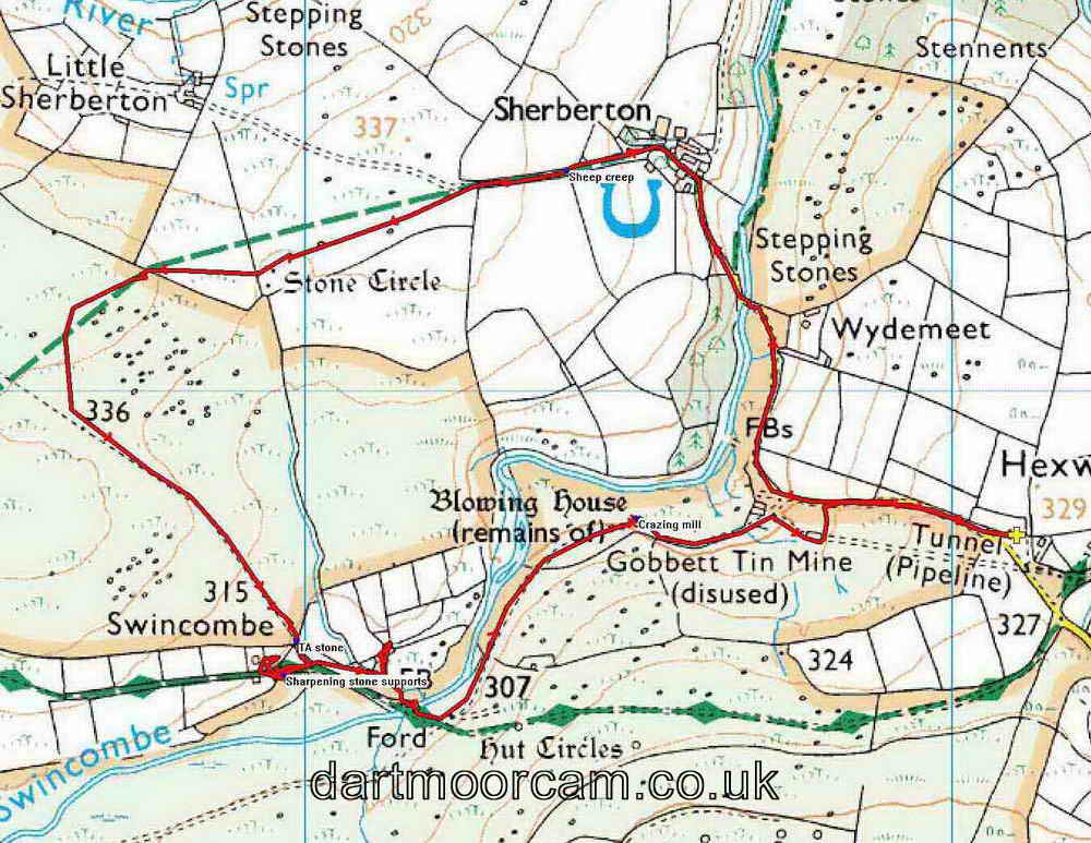


This walk: 2013-11-27. Sherberton Farm, apiary, bees, logs, bridge, planks, sheep creep, buzzard, stone circle, Galloway cattle, tors, Dunnabridge Pound, John Bishop's House, TA stone, Higher Swincombe Farm, grinding stone supports stones, Swincombe Ford Bridge, stepping stones, Gobbett Mine crazing mill, blowing house, mould stone, mortar stones, buddles, wheel-pit, adit, Forest Inn, Queen Victoria's Cross.
This present page gives full screen height photos on pc's with most browsers. It can be a problem on Apple devices - if so, click the Apple-page link.
Link to PAGE 1 of this walk. (there are two pages).
Swincombe Ford Bridge, at Swincombe Steps .....
Another view of the bridge over the River Swincombe (that flows into the West Dart River), showing the stepping stones ..... from the upstream side .....
Ditto, showing the stepping stones more clearly .....
Ditto, from the downstream side .....
Looking upstream, towards Foxtor Mires .....
Looking downstream from the bridge .....
The sad remains of the fairy in the little grotto on the upstream side, on the south bank, almost under the wood.
Almost a clapper bridge over a cutting at the south end of the bridge.
Friendly heifer .....
Friendly heifer, again.
Gobbett Mine crazing or tin mill / stamping mill / blowing house - see diagram below .....
|
|
The Gobbett Mine crazing or tin mill / stamping mill / blowing house is described in J. Butler (1993), Atlas of Dartmoor Antiquities IV, The South East. 662.5 Tinworks in the lower Swincombe Valley, pages 211-212 .....
The larger of two grinding mill stones that was used originally to grind tin ore to a powder form before it was smelted ..... this shows that the site was originally a "crazing mill" and not a "stamping" or "knacking" mill .....
Mould stone for receiving molten tin, complete with two s,all sample moulds in the left edge .....
Mortar stone - this shows that crazing was abandoned in favour of the more efficient stamping process - this needed a leat and a water wheel for power .....
Mortar stone .....
A smaller, presumably upper grinding stone of the crazing mill .....
Another mortar stone .....
Closer view of the larger milling stone.
Looking towards the car park (by the trees at the top right) and the entrance to the adit used to take water from the River Swincombe to Venford Reservoir.
Two buddles? Used to wash the crushed tin ore to separate lighter material from the heavier tin-rich material .....
One of the circular buddles, filled with soft rush.
Water-wheel pit, used to power stamps and the buddles .....
Entrance to the water-carrying adit .....
Zoomed view .....
Closer view .....
PUDC - Paignton Urban District Council, 1929.
Looking downhill from inside the Gobbet Mine gert.
Forest Inn, Hexworthy.
Hexworthy Cross, also known as Queen Victoria's Cross, Hexworthy, this is a relatively modern cross, erected to mark the Diamond Jubilee of Queen Victoria in 1897 .....
VR 1837 1897
|
TO THE GLORY OF GOD |
|
IN COMMEMORATION OF THE |
The cross head, in the style of the Maltese Cross and encircled as in the Celtic tradition.
A view of the cross with the Forest Inn behind.
NOTE .....
MAP: Red = GPS satellite track of the walk.

© Crown copyright and database rights 2012 Ordnance
Survey
Licence number 100047373
Also, Copyright © 2005, Memory-Map Europe, with permission.
This walk is accessed from the Two Bridges-Ashburton road, turning off at the Forest Inn sign near Dartmeet, passing through Hexworthy, passing the Forest Inn and turning right at the top of the hill to park just before the cattle grid. The car park is marked by the yellow cross on the map.
Statistics
Distance - 4.64 km / 2.88 miles.
All photographs on this web site are copyright © 2007-2016 Keith Ryan.
All rights reserved - please email for permissions