![]()


This walk: 2013-1-4. Cist, double stone row, RAF Sharpitor, Peek Hill, cairn, hawthorn tree, Cock's Plantation, Yellow Brain fungus, Golden Jelly fungus, Yellow Trembler, Witches' Butter, Tremella_mesenterica, Cross Gate Cross, Devonport Leat, stacked timber, cairn and cist, Pixy Match and Pixy Cup lichen fruiting bodies.
Walk details below - Information about the route etc.
Link to Google Satellite view of the area - the car park is near top centre.
This was a very misty day - please don't expect too much on this web page!

Cist at SX 55840 70686 (and next photograph), close to the road and car park ("Cist 1" on the map below) ......

Image © J Butler 1994. Reproduced by kind permission (ref. 29
Sept. 2012).
The cairn and its cist are described by J. Butler (1994), Dartmoor Atlas of Antiquities III, The South West. 45.12 Sharpitor North-west single and double stone rows, pages 44-46: where the surrounding stones, or pillars, such as survive are described.

Another view of the cist.

Image © J Butler 1994. Reproduced
by kind permission (ref. 29 Sept. 2012).
The cist seen above is part of the cairn indicated by the arrow at the extreme right of this diagram. The Goatstone Pond that is right beside the main A386 road is indicated above (top left corner of the diagram).
We walked along the double stone row from the cist in a westerly direction for a while, looking for the stones (in two rows!) and the missing stones, in the thick mist! "Miss" knows how to keep us occupied, doesn't she! There is a blocking stone at the east end, near the cist. The row is 113 metres long from the blocking stone to the centre of the terminal cairn at the western end. The distance between the stone rows and the cist is about 75 metres.
From this area, "Miss" walked us up the no-longer-existent road that led to RAF Sharpitor! The road was originally lined on the right side by white-painted stones. I remember the finger signpost that pointed to "RAF Sharpitor" up there, from when I was a nipper, in the back of Dad's car, often wondering what planes, such as Hurricanes and Spitfires and Gannets and Skyraiders they might have up there! Such was young innocence - we lived near RNAS Culdrose, y'see, and we saw the naval versions of these planes on an almost daily basis - naval versions were adapted for flying from aircraft carriers.
Now, if you can find much about RAF Sharpitor on the WWW then you are a better man than me, Gunga Din .............
English Heritage Register of Monuments at Risk Register - this mentions "Prehistoric coaxial field system and cairns, an historic enclosure and part of RAF Sharpitor, situated on and around Peek Hill"
The Royal Observer Corps Remembered web site has a photograph and links to "Location: SX55657003Opened 1963 Closed 1991 Date of visit: Aug 2009Post is demolished. The remains of the access shaft is still visible but backfilled. Nearby rubble is probably from the post."
Widecombe History Group Minutes from October 2007 record: Doug & Lyn Pidgeon brought some details of the RAF Sharpitor Mast for Mike Wright who raised the subject at his talk in September. A good article on the subject can be found in The Dartmoor Magazine number 83, Summer 2006 written by Bill Wilkinson.
The following information is culled from The Field Archaeology of Dartmoor, Phil Newman, (2011), English Heritage, pp.241-242 ..... the site, established from 1942 onwards, is poorly represented even on OS maps from the 1950s because of the secret nature of the site. The Royal Observer Corps could spot aircraft with basic optical equipment. In the 1950s, an underground bunker was constructed nearby to "listen" for nuclear blasts from the testing of nuclear weapons by the Soviet Union. This particular example remained in use until 1991 - a "typo" for 1971? (Source: Subterranea Britannica). The blocked access shaft and two blocked air vents are still visible. The standard three-man ROC bunker had two rooms where the larger, monitoring room was over 4 x 2 metres in dimension. Just north of the ROC post are a few remains of RAF Sharpitor-proper: this was a transmitting station set up early in WW2 to guide British bombers into Europe, being part of the Gee Chain (see here). The main feature was a 64 m (210 ft) wooden mast that was replaced by a metal version in a 1956 upgrade. There were at one point 36 personnel stationed here in Nissen huts etc. The site was largely cleared in 1970.
Another internet record on Pastscape has been suggested by Tim Sandles, Webmaster of Legendary Dartmoor .............
RAF Sharpitor - MONUMENT NO. 1454628
"RAF Sharpitor, a transmitting station established early in World War 2 circa 1942 and abandoned in 1971. This small 'Technical site' served as the master transmitting station for the South Western Gee chain and was one link in the national Gee chain - a radio navigational system that enabled aircraft navigators to fix their position accurately throughout most of Europe. The station had a 210ft wooden transmitting tower and seven nissen huts including a transmitter block. A 'Domestic site' nearby (SX 57 SE 230 ) served as the personnel accommodation area until it was demolished in 1949. The station was upgraded with the addition of a new transmitter block and a 240ft high steel transmitting tower in the mid 1950s. In its heyday 35 service personnel were stationed here including 12 technicians who worked a shift system. The station, located just off the prominent summit area of Peek Hill, was demolished and cleared by 1972. The outline of many of the early buildings traceable as slight brick and concrete foundations up to 0.1m high were surveyed in 2007"
Google Map link to the RAF Sharpitor site.

Bronze Age cairn at the summit of Peek Hill, SX 556 699, elevation 400 metres (1312 feet).

Gorillas in the Mist gathered at a more recent concrete structure (a Cold War bunker) on Peek Hill / RAF Sharpitor.....
Closer view of a concrete cist - more Iron Age?! Actually, the entrance to the bunker. There were steps down to a room with a table and a bed until it was vandalised: then it was sealed shut.

On such a misty day, I had to photograph something! A hawthorn tree.

Last of the Mohicans disappearing into Croft's Plantation.

Striking tree trunk left standing by gates onto the road from Lowery Cross to Cross Gate .....

Yellow Brain fungus, golden jelly fungus, the yellow trembler, and witches' butter, Tremella_mesenterica, frequently found on dead gorse.

As previous .....

As previous.
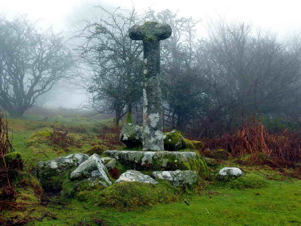
Cross Gate Cross, at SX 56175 69495, beside the Devonport Leat. .

Devonport Leat, crossing under the road, running towards Plymouth .....


Devonport Leat, looking upstream.

Felled timber stacked beside the track at SX 5630 6949 .....

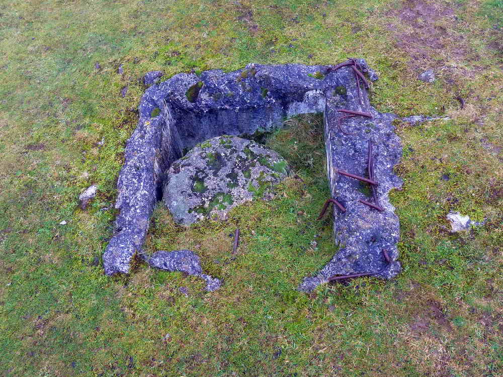
Cairn and cist at SX SX 56321 69520 ("Cist 2" on the map below) .....

Closer view .....

Image © J Butler 1994. Reproduced
by kind permission (ref. 29 Sept. 2012).
The cairn and its cist are described by J. Butler (1994), Dartmoor Atlas of Antiquities III, The South West. 45.17 Leather Tor South cairn and cist, page s 51-52. This is described as a well-preserved cairn and cist, first rescorded in 1935. The robbers trench came in the the south-east, displacing the end stone downhill where it is now partly covered by the capstone.

Showing the proximity of stacked timber to the ancient monument.

Imposing sections of tree trunks.
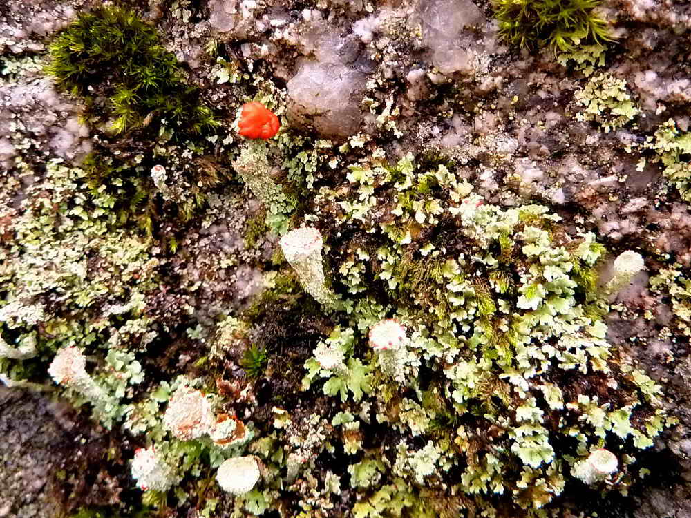
Pixy Matchstick (red-tipped) and Pixy Cups - fruiting bodies of lichens. The red tipped fruiting body could be Cladonia floerkeana, known locally as Dartmoor matchsticks, pixies' matchsticks or as devil's matches - this species is very like a matchstick. Alternatives would be C. diversa (fruiting stalk is branched), C. macilenta (red tip is very narrow compared to diameter of the stalk) and Dibaeis basomyces (fruiting bodies are short and fat). Several Cladonia species can be seen here. The Pixy Cups are also commonly indicative of Cladonia species (and a few other genera). These are structures that bear (1) soredia - minute pieces containing both the algal and fungal components of the lichen that can blow away in the wind or (2) isidia - firm outgrowths where the fungal and algal components remain attached but can break off.

Crossing Devonport Leat .....

Chalara fraxinea notice. Click on the photograph to see a larger version.

A probable flow-monitoring station on Devonport Leat ......

Closer view .....

A small waterfall in the leat .....

A series of "rapids" if you can have such a thing in a smallish stream or leat .....
Dartmoor CAM movie.
TIPS .....
Devonport Leat in full spate after heavy rain. |
|
Click the photo to download File size: 2 MB. Time to download: e.g. 13 secs Length 18 secs |
If you want to see water running in Roborough Common's leats that are supposed to be dry since Burrator Reservoir opened in 1898, click HERE .....

Looking back along the leat .....

As The Last of the Mohicans disappears back into the mists of the forest.

"There we go" ....................... back into the mists, whichever way.
MAP: Red = GPS satellite track of the walk.

© Crown copyright and database rights 2012 Ordnance
Survey
Licence number 100047373
Also, Copyright © 2005, Memory-Map Europe, with permission.
The five marker flags denote the locations of
DPA boundary
stones
that were located during a walk on 24 May 2008
- I keep them here so as not to lose them!
This walk was reached by driving from Yelverton towards Princetown and parking on the left after descending Peek Hill at the P symbol /and yellow cross on the map.
Statistics
Distance - 5.17 km / 3.21 miles.
All photographs on this web site are copyright ©2007-2016 Keith Ryan.
